Atmospheric river pummels Northern California. Why is it called a bomb cyclone?
Northern California is in the middle of a dramatic weather shift. From bitter cold to widespread rain and significant Sierra snow, impacts peak through Saturday during the first major storm of the season.
The region has been hit with multiple rounds of heavy rain and Sierra snow this week, which bring flooding concerns and travel impacts through the weekend before Thanksgiving.
Atmospheric river impacts through the weekend
A strong atmospheric river is expected to deliver significant rainfall and snowfall through the weekend.
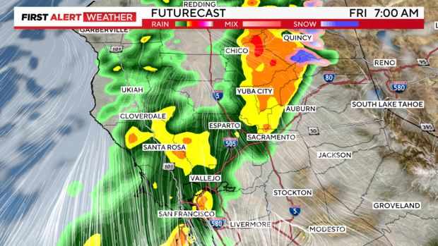
The action started late Tuesday night across the Sacramento Valley as the atmospheric river made landfall across the North Coast. Rain and snow amounts peaked on Friday, especially north of I-80.
Sacramento and its surrounding suburbs heavy rainfall throughout the day. On Friday, rainfall amounts recorded in Sacramento broke the city's all-time record — 1.07 inches in 1978 — for this date (November 22). As of 4 p.m., Sacramento had received 1.26 inches for the day and counting.
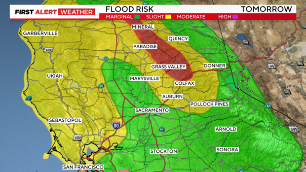
A Flood Advisory was issued through Saturday morning for the northern Sacramento Valley as prolonged periods of moderate to heavy rain will cause flooding and flash flooding risks.
Flooding Concerns:
- Burn scars face a high risk of debris flows.
- Sharp rises are expected on rivers and creeks.
- Poor drainage and urban street flooding
In areas not under the Flood Watch, urban flooding will still be possible around poor drainage areas and leaf-clogged storm drains.
On Thursday, rain tapered in the Valley south of I-80 but remained steady in the northern Sacramento Valley. Snow levels also increased to above 8,000 feet Thursday afternoon.
Expect this weekend to be a wet one with more valley rain impacting the weekend before Thanksgiving.
Travel across the Sierra will also be impacted with possible chain controls in effect through the weekend. Road conditions and chain control status can be viewed here.
72-hour rainfall totals
Here are the 72-hour rainfall totals as of 10 p.m. Friday:
- Paradise: 17.01 inches
- Oroville: 8.06 inches
- Grass Valley: 5.66 inches
- Yuba City: 4.78 inches
- Auburn: 3.17 inches
- Sacramento International: 3.0 inches
- Stockton: 0.42 inches
Multi-day projected rain and snow totals
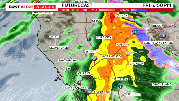
Much of the Sacramento Valley saw rain by Friday morning and it shifted to the San Joaquin Valley area by the evening.
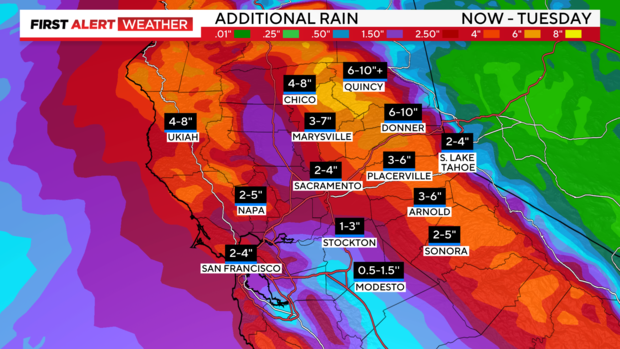
Expected rainfall totals between Thursday evening and Tuesday are:
- North Sacramento Valley: 4-8 inches
- South Sacramento Valley: 2-4 inches
- San Joaquin Valley: 1-3 inches north of Stockton, 0.5-1.5" Modesto southward
- Foothills South of Highway 50: 2-5 inches
- Foothills North of Highway 50: 3-6 inches, locally 6-10 inches in western Plumas, Sierra, and northern Yuba County
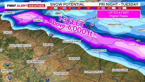
The rain then transitioned into snow by Friday evening in the Sierra with anywhere between 1-3 feet of snow above 6,000 feet expected from Friday night through Tuesday.
Amounts will be dependent on snow levels, as atmospheric rivers are known for higher snow levels because of the warmer moisture they transport.
With a lot of heavy snow on the way, it's important to check road conditions often and be prepared for winter travel across the Sierra. Chain controls and delays are expected.
A Winter Strom Warning is in place for Calaveras, Placer, Plumas and Shasta counties until 4 p.m. Tuesday.
What is an atmospheric river and bomb cyclone?
As our first atmospheric river event of the season arrives, many question: What is an atmospheric river?
Some may know it as the "Pineapple Express" -- and, yes, atmospheric rivers are the same.
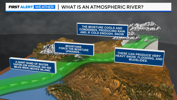
Atmospheric rivers are relatively long, narrow regions in the atmosphere, like rivers in the sky that transport most of the water vapor outside of the tropics. Along the West Coast, our moisture comes from the tropics near Hawaii and gets directed to the coastline.
Atmospheric rivers can vary greatly in size and strength, the average atmospheric river carries an amount of water vapor roughly equivalent to the average flow of water at the mouth of the Mississippi River, according to the National Weather Service.
Atmospheric rivers can be directed into the West Coast thanks to mid-latitude cyclones, commonly referred to as bomb cyclones. 'Bombogenesis', a term used by meteorologists, occurs when a midlatitude cyclone rapidly intensifies over a 24-hour period. Our storm system this week has undergone that strengthening, hence why many are calling it a bomb cyclone.
Simply put, a bomb cyclone is how quickly a storm strengthens and an atmospheric river is a steady stream of moisture coming from the tropics. Separate pieces of the storm system, but can work together to enhance rain and snow totals.
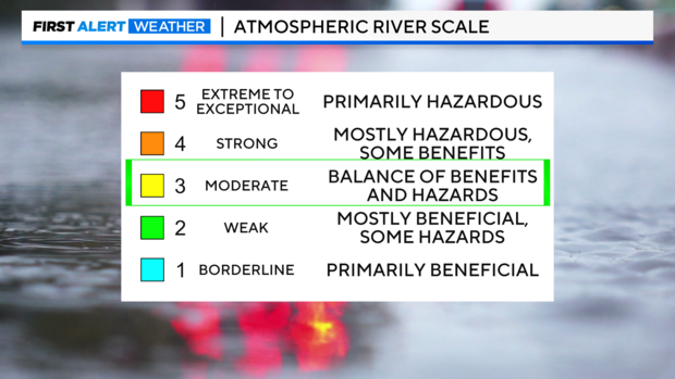
With an atmospheric river, there are five categories with each varying in strength and impacts.
Not all atmospheric rivers cause damage. Most atmospheric rivers often provide beneficial rain or snow that is crucial to the state's water supply. But, if an atmospheric river stalls in one location for multiple days, the impacts can be hazardous.
The atmospheric river to make landfall this week is between a 3 and a 4 on the scale. This means it will be mostly beneficial, thanks to our dry soils, but can provide some hazards including flooding.
Make sure to stay with the CBS Sacramento First Alert Weather team this week as we keep you updated on the impacts we could see and how long the rain and snow stay around.

