After few mild days, another Northern California summer heat wave on the horizon

SACRAMENTO — After a short stint of mild and seasonable weather in Northern California, our weather pattern has taken another hot turn.
Temperatures began to heat up into the triple-digits Thursday with more heat expected next week. More major to extreme heat risk is possible through early next week as temperatures climb.
The next heat wave
Temperatures in recent days have stayed mild and cooler than average thanks to an onshore flow, also known as the Delta Breeze in the Sacramento Valley.
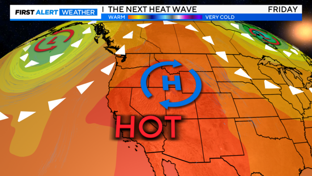
Drier air and heat filled in Thursday as high pressure rebuilt across the Four Corners region including Utah, Arizona, Colorado, and New Mexico.
High pressure inching closer to California will increase temperatures both Thursday and Friday.
A small area of low pressure will develop off the coast of Northern California on Saturday, helping to cool temperatures just slightly on Sunday as a weak Delta Breeze redevelops.
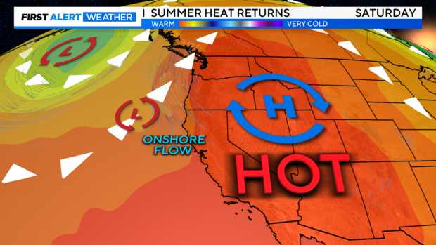
Our slight cooldown will be short-lived as high pressure moves in again by Monday. This will lock in more heat through Wednesday of next week.
Luckily, this next heat wave does not look as robust and long-lasting as the last. However, it will be something we'll watch for in model runs over the next few days.
Triple-digit heat lingers
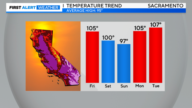
The return of widespread triple-digit heat is expected to begin on Friday. Highs will range from around 100-107 degrees, with the warmest temperatures expected in the northern Sacramento Valley. Friday will be a First Alert Action Day as heat risk increases.
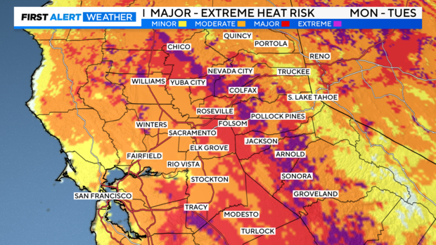
Areas of moderate to major heat risk will be possible. This level of heat affects most heat-sensitive groups, especially those without adequate hydration or cooling. Consider shifting the timing of outdoor activities to avoid the hottest part of the day between 1 p.m. to 7 p.m.
We'll lose a few degrees this weekend as high-pressure overhead moves slightly and our Delta Breeze pulls in some cooler air. The weekend will still be warm with highs in the mid to upper 90s for those with a Delta influence and low 100s for the rest of the Valley.
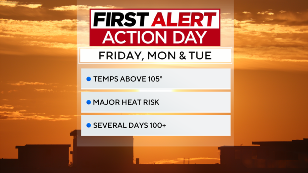
The worst of the heat over the next five days will arrive on Monday and Tuesday as highs climb above 105 degrees for most of the Sacramento Valley and Central Valley. Both Monday and Tuesday will be First Alert Action Days.
For the Sierra Foothills, highs will range from the upper 90s to 105 degrees. Highs in the low 90s are expected across higher elevations in the Sierra Nevada.
Widespread hot afternoon temperatures will be followed by little overnight relief with lows in the upper 60s to 70s. Make sure to do what you can during the day to keep your home cooled off during the day.
Areas of major to extreme heat risk will be likely from the Sacramento Valley to the foothills of the Sierra Nevada.
Tuesday will bring more of the same, before temperatures cool by a few degrees by Wednesday, July 24.
Staying protected in the heat
When heading into another heat wave, it is important to do what you can to keep yourself cool and hydrated. Wear loose-fitting clothing and light colors and stay hydrated throughout the day.
Don't forget about your furry friends either. Try to take your pet on walks early in the day or late at night after the pavement has cooled down. Also, bring them indoors, if possible, during the peak heat of the day.
If your air conditioner has a hard time cooling your house down, keep your blinds closed during the day and try opening your windows late at night to get some cooling.
If you plan on visiting waterways, make sure to wear a life jacket. The rivers are still running very fast and cold.
Stay with the CBS Sacramento First Alert Weather team for the next few days as we track our next round of summer heat.