First Alert Weather: Storm moving across Northern California
A powerful winter storm is expected to bring several inches of rain and heavy winds to Northern California.
Sacramento morning weather forecast: Jan. 6, 2023
Here is how the next seven days of weather are going to look.
Overnight snowfall
Chain controls were still in place along major Sierra highways Tuesday night.
On I-80, the restrictions were in place between Kingvale and Hirschdale Road in Truckee. On Highway 50, chains were required between Twin Bridges and Meyers. See updates on chain controls here.
The National Weather Service Sacramento said several inches of snow is possible overnight in the Sierra before the storm comes to an end. Additionally, a dense fog advisory was in effect for the northern San Joaquin Valley through 11 a.m. Monday.
Highway 50 closed at Echo Summit
Caltrans is holding traffic on Highway 50 over Echo Summit due to avalanche control work. At this time, it is unclear how long the closure will be in place.
Chains required again on I-80
Caltrans said Tuesday evening that chain controls were back in effect for Interstate 80 travelers between Kingvale and the Donner Lake interchange.
Eastbound trucks are being screened at Applegate in Placer County while westbound trucks are being screened just over the border into Nevada in the Mogul area.
Chains on Highway 50
Caltrans said late Tuesday afternoon that chains were required on Highway 50 between Twin Bridges and Meyers over Echo Summit.
Additionally, chain controls are also in place on CA-89 over Luther Pass, which is located south of South Lake Tahoe and Meyers, and Highway 89 is closed around Emerald Bay due to snow.
The other major corridor through the Sierra, Interstate 80, currently has no travel restrictions.
Yosemite road closure
Officials say a "significant" rockfall has blocked one entrance to Yosemite National Park.
The rockfall happened around 9 a.m. Tuesday, according to the park, on El Portal Road.
Due to the incident, the Highway 140 entrance to the park is blocked and is expected to be closed for a few days.
Visitors can still get into the park through Big Oak Flat Road and Wawona Road for the time being.
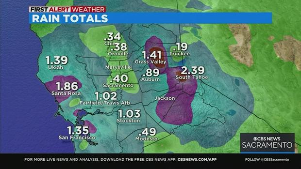
Rain totals as of 10 a.m.
Here are the rain totals so far.
Watch the full forecast below.
Updated: AT&T lines down in Elk Grove
Police in Elk Grove are dealing with lines that have fallen into the roadway along Elk Grove Boulevard. Initially, police said they were power lines, but it turns out they belong to AT&T.
The major thoroughfare is now closed between Bradshaw and Grant Line roads due to the incident. It's unclear when the road will be back open, police say.
El Grove police say AT&T is aware of the incident and a crew is on the way to the scene. It's unknown when the roadway will reopen to vehicles.
Chain controls lifted
California Highway Patrol says the I-80 chain controls have already been lifted.
However, officials are still warning drivers that roads and extremely wet and slippery at the moment. Drivers should slow down and proceed with extreme caution.
Snow levels are expected to drop later on Tuesday.
I-80 chain controls
Chain controls are now in effect on one major Sierra highway.
On Interstate 80, westbound is R2 rom the Donner Lake interchange to Rainbow. Eastbound is R2 from Kingvale to Donner Lake, Caltrans says.
For the moment, Highway 50 has no restrictions.
SacRT bus bridge in effect
A bus bridge is in effect on the Gold Line from Mather Field/Mills to the Sunrise stations in both directions, Sacramento RT says.
Exactly what is prompting the need for a bus bridge is not clear.
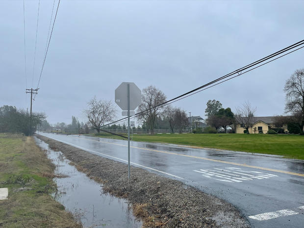
Rainy morning for NorCal
Moderate to heavy rain is moving through Northern California on Tuesday morning.
Drivers are being urged to use caution on their morning commutes.
Snow is currently falling at elevations above the 6,000' level.
Monday night forecast
National Weather Service warns of localized flooding
The National Weather Service is warning that heavy rain between now and Tuesday could lead to localized urban flooding and increased runoff in the Sierra.
They also warn of isolated thunderstorms bringing lightning and hail.
Check the latest road conditions in California, here.
First round of storm to arrive Monday night; here's what to expect
A powerful winter storm is expected to hit Northern California starting late Monday and bring several inches of rain and heavy winds.
The National Weather Service office in Sacramento called it a "major weather pattern change" that will "bring multiple rounds of rain and snow through the week and through the weekend."
An atmospheric river, or a weather system that moves high concentrations of water vapor outside of the tropics, could on Tuesday bring up 1 to 3 inches of rain to the coastal areas, with higher elevations receiving upward of 3 to 5 inches, the National Weather Service says.
The atmospheric river could be as strong as a Category 3, with a scale that tops out a 5.
A low-level pressure system currently forming is set to push through Washington late Tuesday and pull a plume of very moist air over California early Tuesday through early Wednesday, according to the NWS.
Timing the storm
- 7 p.m. Monday - Lighter rain arrives in the region.
- 2 a.m. Tuesday - Leading edge of the storm moves in.
- 4 a.m.-8 a.m. Tuesday - Continue to see heavy rain in the valley, foothills, and the Sierra. It will move down into the San Joaquin Valley.
- 12 p..m. Tuesday - Showers subside.
- Wednesday 7 a.m. - Dense fog settles in, resulting in zero visibility on the streets.
Sierra Watches and Warnings
The National Weather Service says a high-wind warning will go into effect Monday at 10 p.m. and stay in effect through Tuesday at 10 p.m. They say there will be southwest winds up to 65 mph and 100+ mph gusts along the ridges. High-profile vehicles will have travel difficulties. There will be possible damage to trees and powerlines. Power outages are expected. The Service also warns of dangerous boating conditions.
A wind advisory will be issued for the western Nevada Basin and Range, including Pyramid Lake. That advisory goes into effect at 10 p.m. Monday and stays in effect until 10 p.m. Tuesday.
A winter storm warning will go into effect at 10 a.m. Tuesday and remain until 10 a.m. Wednesday for Mono County and the Greater Lake Tahoe area.
A winter weather advisory will go into effect at 10 a.m. Tuesday and remain until 10 a.m. Wednesday for Lassen, eastern Plumas, and eastern Sierra counties, the National Weather Service says. They say travelers should plan on difficult travel conditions in the easter Sierra passes over on Tuesday, becoming more widespread Wednesday.
A Backcountry Avalanche Watch is in effect for eastern Sierra in Inyo and Mono counties.
Weather Tools
- Download the CBS13 Weather App and get access to live, interactive radar
- Visit the CBS13 Weather Center for radar images, 7-day totals, the latest video forecast, and more.
- Are you a News Hound? Share your weather footage with us or become a Weather Watcher.
- Visit the CBS13 Weather Facebook page for weather discussion and more.
The shift in weather comes as millions of Americans deal with a frigid winter storm that has gripped much of the United States.
CBS News has confirmed at least 38 weather-related deaths nationwide from that storm.
The scope of the storm has been nearly unprecedented, stretching from the Great Lakes near Canada to the Rio Grande along the border with Mexico. About 60% of the U.S. population faced some sort of winter weather advisory or warning, and temperatures plummeted drastically below normal from east of the Rocky Mountains to the Appalachians, the National Weather Service said.
Thousands of U.S. flights were canceled Saturday, and nearly 3,000 as of Sunday night, according to the tracking site FlightAware.