Pittsburgh Weather: Winter Storm Watch Issued For Saturday, Snow Could Total 3-6 Inches
By: Mary Ours, Ray Petelin and Ron Smiley/KDKA-TV News Staff
PITTSBURGH (KDKA) -- Compared to Wednesday's late-winter snow, today will be beautiful with average highs near 50 degrees. High pressure keeps us nice and quiet throughout the day on Friday, but big changes are on the way for Saturday.
The National Weather Service has issued a Winter Storm Watch for much of Western Pennsylvania, east-central Ohio and the northern panhandle of West Virginia. It will go into effect at 1 a.m. Saturday through 1 a.m. Sunday.
Three inches of snow fell officially at the airport on Wednesday. What a crazy day. Ron Smiley did a recap yesterday just before noon.
Right Now: An almost perfectly normal day for this time of the year.
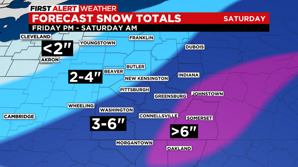
Alert: Overnight Friday into Saturday morning snow moves in with a general 2-4" for Pittsburgh and higher amounts in the Ridges and Laurels where there's a Winter Storm Watch starting Friday evening and going until 1 a.m. Sunday with reduced visibility and white-out conditions in Garrett County, Maryland.
Aware: Sunday lows drop to near 10 degrees. Nice warm-up occurs as we head into the next work week with high temperatures back near 60.
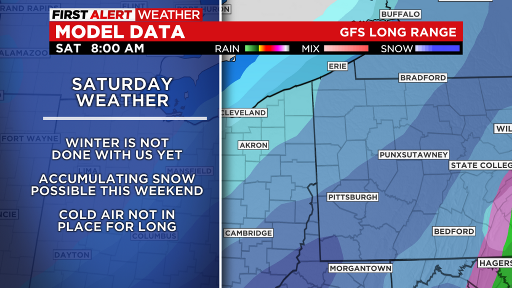
As always in Pennsylvania, the weather hardly gives you a break and our next big system is set to arrive on Saturday as a trough of cold air moves in from the west just behind a warm front that lifts through.
The front will bring high moisture levels that will fuel the potential for big snow totals.
The most widespread and heaviest snows will occur from midnight until about 4 a.m. or 5 a.m. on Saturday. This is where the bulk of the accumulation is expected to occur. By 7 a.m. or 8 a.m. on Saturday, the snow will become scattered, but gusty winds and dropping temperatures will remain.
St. Patrick's Day Parade will be snowy and slushy with temperatures hovering the upper 20s.
WEATHER LINKS:
Current Conditions | School Delays & Closings | Local Radar | Weather App | Photos
Sunday will start the snow melting process with sunshine but below-average temperatures. Spring makes another comeback for most of next week, leading up to the St. Patrick's Day holiday on Thursday. Temperatures will be in the 50s/60s with mostly dry conditions.
Don't forget we spring forward and lose an hour of sleep this weekend, but have later sunrise and sunsets.
Today is dry with high temperatures near 50 degrees.

Winds will be calm for the day with partly sunny skies. There was some fog around this morning, which was the thickest around rivers and low-lying moisture sources.
Stay up to date with the KDKA app, which you can download here.