The Pittsburgh area will see a brief cooldown today after last week's heat and humidity
PITTSBURGH (KDKA) -- The heat and humidity has finally broken in the Pittsburgh area.
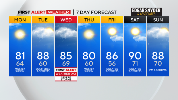
Any Alert Days Ahead? Wednesday is a First Alert Weather Day due to storm chances.
Aware: Only one 90 degree day in my forecast over the next week with the day landing on Saturday.
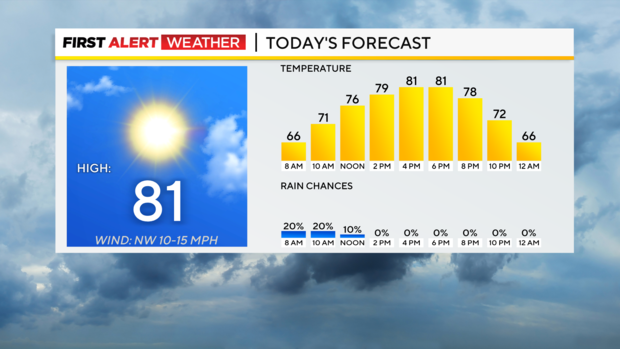
Highs yesterday 'only' hit 86°. Today's high will be close to 80 degrees. I have Pittsburgh hitting 81° for today's high. Temperatures will be in the mid 70s around noon. Skies will be mostly sunny today with winds coming in out of the North at 5-10mph.
Looking ahead, I am going to continue with a small storm chance on Tuesday afternoon. Some of my preferred models continue to show that storm chance for the afternoon even though most data is showing us dry. Any rain would arrive after 4p with scattered storms being possible. Storm chances peak on Wednesday.
We are already a level 2 out of five when it comes to severe weather chances for Wednesday. Severe weather chances will come from strong straight-line wind for everyone.
The further east you go, the higher the large hail risk as well. Obviously, anytime you have a severe weather risk tornadoes are possible.
Looking at last week, we saw four days last week hit 94°. Dubois saw 6 records set last week with four of those due to high temperatures and two additional records being set due to the overnight temperature being the warmest on record.
WEATHER LINKS:
Current Conditions | School Closings & Delays | Submit Your Weather Photos