The heat sticks around in Pittsburgh as stormy weather approaches to start the week

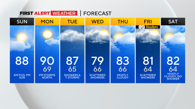
PITTSBURGH (KDKA) - Sunday morning begins very muggy with areas of dense fog across western Pennsylvania. The most problematic areas are north and northwest of Pittsburgh where some observation sites are reporting visibility around ¼ mile.
As daytime heating and a slight breeze commence, this will ultimately allow that fog to mix out by mid-morning. The rest of the afternoon will feature mostly sunny, seasonably hot, and slightly muggy although not completely oppressive humidity.

WEATHER LINKS:
Current Conditions | School Closings & Delays | Submit Your Weather Photos
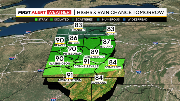
Overnight into Monday morning, expect lows in the mid-60s to near 70 under mostly clear skies. The mild overnight into Monday morning will lead us into another hot day with highs likely reaching the mid-80s in northwest Pennsylvania.
Isolated thunderstorms may develop in portions of Northwest Pennsylvania during the afternoon and evening hours as a weak cold front slowly begins to drop in from the northwest. There will be some instability and potential for storms to contain gusty outflow winds.
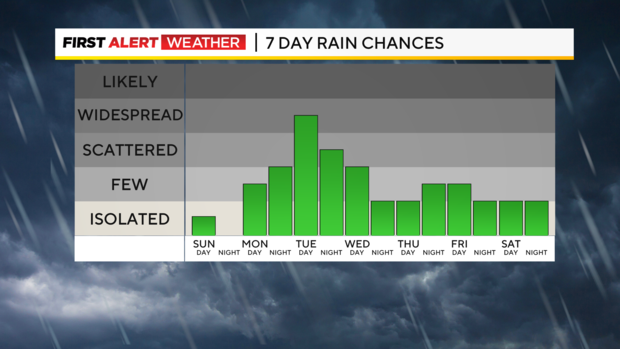
However, the severe weather parameters do not look overly impressive. Most thunderstorms will weaken by the time they move southeast into the Pittsburgh area near sunset and after dark Monday night into Tuesday morning.
The cold front will continue its progression southward through the day Tuesday. The area from Pittsburgh and points south will likely be warmest with highs in the mid to upper 80s with cooler temperatures over the northern half of our area. Tuesday also has the highest rain coverage with numerous showers and storms likely, especially during the afternoon and evening hours.
An isolated severe storm is possible with the main threats being strong wind gusts.
Lingering clouds and showers are expected on Wednesday as the cold front will likely stall out and get hung up in or just south of our area. This is mainly due to the fact that we will be watching the remnants of what will be Hurricane Debby work their way into the Carolinas.
As of now, it is likely that this system will not have many impacts on western Pennsylvania, except for a few rain showers late Thursday through late Friday. Higher rainfall amounts and coverage will likely be east of the Appalachians before Debby gets carried out to sea by a cold front late in the week.
Stay up to date with the KDKA Mobile App – which you can download here!