Stormy weather is expected this afternoon in the Pittsburgh area
PITTSBURGH (KDKA) -- Today's going to be a busy weather day with storms expected throughout the Pittsburgh area.
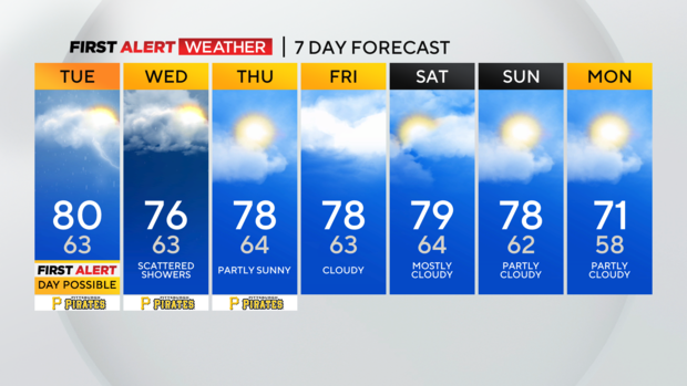
Any Alert Days Ahead? Today is the best chance for a First Alert Weather Day over the next week. Holding off for now.
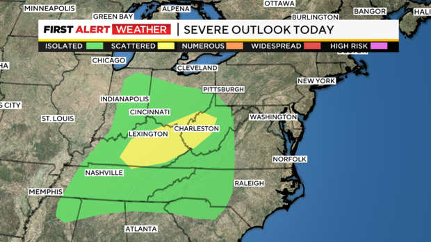
Aware: NOAA's Storm Prediction Center has a small sliver of Greene County under a severe weather risk today including a fairly high 2% tornado risk.
A number of communities should see right at an inch of rain from start to finish with a couple of rounds of rain expected to sweep through. Rain began early this morning with a couple of scattered showers riding along a warm front that will bring a brief warm-up our way. I have bumped up Pittsburgh's high to 80° today.
The warm-up will start around 10 a.m. with temps shooting from the mid-60s at 10 a.m. to the mid-70s at 11 a.m.
I have us hitting 80 degrees at 3 p.m., just ahead of storm chances rolling through ahead of a cold front.
As of 4 a.m. most of our area has been left out of NOAA's Storm Prediction Center severe weather risk map.
I think more of our area will be included under the risk map as the day goes on. In my forecast, we will have ample instability in place ahead of a trigger mechanism in the cold front that will push through during the evening commute. Storms could begin as early as 3 p.m.
There could be as many as three waves of storms that come through but I think most only see one or two. The highest chance for severe weather will remain to the south of I-70. Strong wind is my biggest concern. Frequent lightning and even a brief downpour should also be expected.
The strongest storms should be over by 9 this evening with scattered showers remaining overnight and through Wednesday morning. The next 24 hours will be the best chance for rain over the next week. That could change though with tropical moisture heading our way with Helene.
This storm is expected to rapidly intensify as it makes landfall somewhere along the Florida and Alabama coast before heading inland. Data shears the storm out before it arrives here with us only seeing light showers late Friday and Saturday from whatever is left over. The best chance for seeing any rain from Helene will come to those south of I-70.
Looking ahead temperatures should fall to the mid-70s for highs on Wednesday with highs near 80 degrees on Friday, Saturday, and Sunday. Temperatures wind up back to near normal on Monday.
WEATHER LINKS:
Current Conditions | School Closings & Delays | Submit Your Weather Photos
