Rain and storm chances continue this weekend in Pittsburgh before more heat moves in

PITTSBURGH (KDKA) - Saturday morning begins with mostly cloudy skies, and warm and sultry conditions across western Pennsylvania.
WEATHER LINKS:
Current Conditions | School Closings & Delays | Submit Your Weather Photos
There are a few scattered showers across eastern Ohio and portions of northern West Virginia, but there will likely be more than that coming up later this afternoon. A trough of low pressure is currently situated in eastern Ohio but will move into western Pennsylvania coming up later today.
That will increase the chance for showers and storms along with locally heavy rain beginning by midday and lasting through this evening. The highest rain coverage will generally be from Pittsburgh and points north and east. With plentiful moisture in the atmosphere, locally heavy rain is possible. Some high-resolution modeling suggests localized swaths of 1-2+" of rain which could cause runoff and localized flooding despite recent dry conditions.
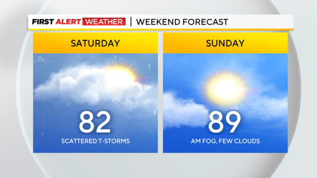
Overnight, into Sunday morning, most of the scattered rain will shift toward areas such as the Laurel Highlands, West Virginia, and northwest Maryland, but drier air should move into areas from Pittsburgh west and north leading to some clearer skies and better conditions for the second half of the weekend. Patchy dense fog is likely, especially in valleys and low-elevation areas Sunday morning.
This will mix out by mid-morning.
After the weekend system departs, a southwest wind will once again transport unseasonably hot air into western Pennsylvania.
Daytime high temperatures will soar into the upper 80s to low 90s areawide, especially by Monday which will continue to add onto the already above-average streak we've seen so far this summer. A series of weak weather systems will move in from the northwest late Monday through early Wednesday and force a cold front to slowly move south into the hot and humid air mass ahead of it.
This will likely lead to additional spotty storm chances followed by some cooler and drier air by mid to late next week.
We will be watching the tropics as well for what will likely be Tropical Cyclone Debby moving up the Carolinas into the mid-Atlantic by mid to late next week.
As of now, it is likely that this system will not have many impacts on western Pennsylvania, but rain chances could increase for southeast Pennsylvania into Maryland as that system moves northeast before getting carried out to sea.

Stay up to date with the KDKA Mobile App – which you can download here!