Storms develop in Pittsburgh on Saturday afternoon ahead of a cooler, drier Labor Day
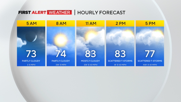
PITTSBURGH (KDKA) - Saturday morning begins very warm and slightly humid across most of western Pennsylvania and northern West Virginia under mostly clear to partly cloudy skies.
WEATHER LINKS:
Current Conditions | School Closings & Delays | Submit Your Weather Photos
All eyes today will be on a weak disturbance aloft that will slowly force a cold front to move across our region this upcoming weekend bringing an end to a five-day stretch with highs in the 90s. Clouds will increase in coverage through the late morning hours and some isolated to scattered thunderstorms are possible across portions of far northern and northwest PA through the mid-morning to midday hours.
As temperatures heat up around midday, we expect scattered to numerous showers and storms to develop between 12-2 p.m. along or just west of I-79 and move east through the afternoon and evening hours.
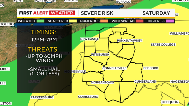
The Storm Prediction Center continues a level 2 out of 5 "slight risk" for severe weather. The main threat of storms is strong downburst winds up to 60mph, although a majority of people will probably see winds that are less than that. Some hail is possible too (1" or less in most cases), but individual storm cores may not be long-lived and persistent enough to allow for hail sizes to grow to very large levels.
The area most likely to see storms turn severe would be from Pittsburgh and points south and east toward the Laurel Highlands and south toward northern West Virginia where the atmosphere will have a longer time to become more unstable and where higher amounts of moisture will be in place. If you are traveling to any of the college football games across our region, make sure you have a way to receive warnings and bring rain gear.
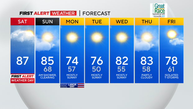
Expect a few lingering storms in our southeast areas Saturday night into early Sunday morning, before drier air moves in on Sunday. Sunday will feature another day with highs in the low to mid-80s, but a reinforcing blast of cooler air arrives with the actual cold front passage Sunday evening making way for a near-perfect Labor Day.
Seasonal temperatures look to linger through the middle of next week before we become unseasonably warm again by the end of the week with a chance of showers by next Friday.
Stay up to date with the KDKA Mobile App – which you can download here!