Rain chances increase in western Pennsylvania on Saturday night into Sunday
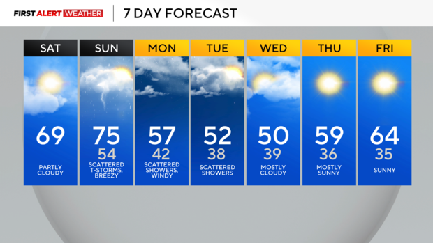
PITTSBURGH (KDKA) - Saturday begins with mostly clear to partly cloudy skies and considerably milder temperatures compared to Friday morning thanks to a light southwest breeze across the region.
Clouds will increase through the mid-morning to midday hours as a weak cold front moves in from the north and ultimately stalls out across our viewing area.
WEATHER LINKS:
Current Conditions | School Closings & Delays | Submit Your Weather Photos
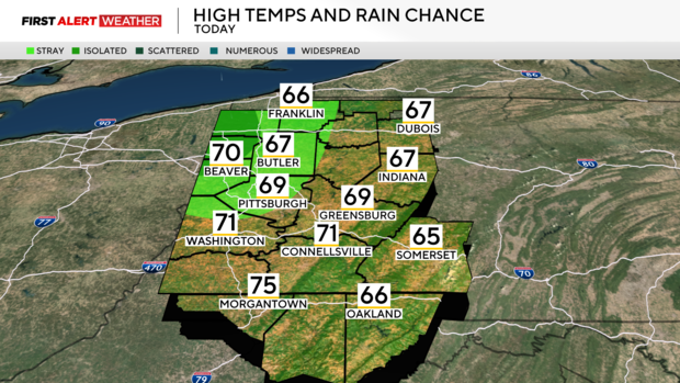
This will lead to a slight range in temperatures with our northern counties only reaching the mid to upper 60s, while locations from Pittsburgh and points south will be closer to 70 degrees and even lower 70s across Northern West Virginia. As moisture levels aloft in the atmosphere begin to increase, an isolated shower cannot be ruled out for portions of eastern Ohio and far northwest PA by late afternoon, although coverage will be isolated at best.
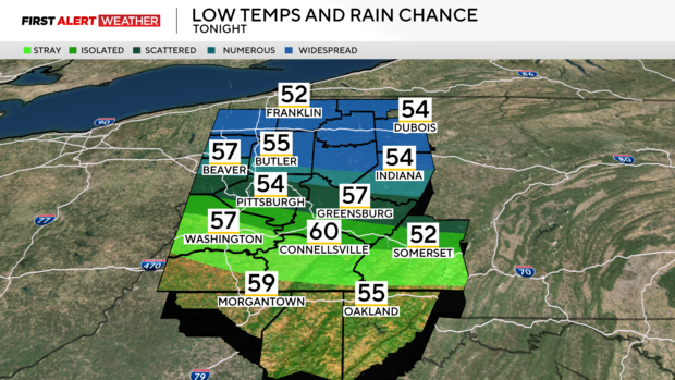
Skies will become mostly cloudy with areas of showers and possibly a few thunderstorms after midnight Saturday into Sunday morning, especially from Pittsburgh and points north along a warm front.
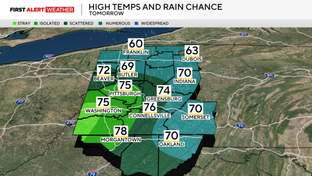
Winds will be breezy out of the southwest most of the day Sunday ahead of the cold front and gradually strengthening area of low pressure which means most locations will likely top out in the mid-70s. The cold front will arrive around sunset Sunday with additional scattered showers and storms.
At the moment, the severe weather potential remains very low as models point to a lack of moisture and instability, but a couple of storms, especially toward the Laurel Highlands may contain sub-severe hail and strong winds by Sunday afternoon and evening. There will be a break in precipitation for most of Sunday night as a dry slot moves in behind the cold front.
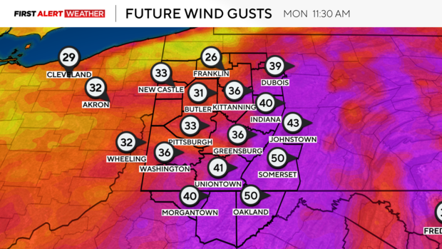
High temperatures on Monday will likely occur at midnight following the frontal passage with a colder and blustery day. There is an increasing potential for high winds through the morning to early afternoon hours of Monday as the low pressure to our northeast rapidly intensifies and strong jet stream energy from aloft mixes down to the surface. Models currently indicate gusts of 30-40mph, but higher gusts of 50mph can't be ruled out in the Laurel Highlands and the Ridges.
The area of low pressure will likely stall to our northeast until Wednesday night this week. Cold air aloft moving over the Great Lakes will lead to several mostly cloudy days with lake effect showers. We cannot rule out some wet snowflakes or some graupel, especially during the evening hours of Monday and Tuesday for parts of Northwest PA, but significant accumulation is not expected due to relatively warm ground temperatures. A gradual warming trend is expected to ensue by the end of next week.
Stay up to date with the KDKA Mobile App – which you can download here!
