Pittsburgh Weather: Tornado Watch issued for parts of area
PITTSBURGH (KDKA) -- A Tornado Watch has been issued for several Pittsburgh-area counties.
Tuesday is a First Alert Weather Day due to the potential for strong storms, including destructive straight line wind in the evening.
Today: A First Alert Weather Day has been issued due to potential strong storms this evening. We'll also see a round of rain from around noon through 5 p.m.
Alert: A Tornado Watch was issued for parts of the Pittsburgh area until 9 p.m. It includes Butler, Washington, Lawrence, Fayette and Greene counties. It also covers parts of Indiana, Kentucky and Ohio.
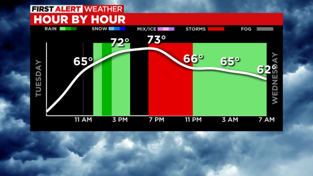
There's an evening storm risk with a couple of lines of storms possible after 7 p.m. Straight line wind is the main concern but large hail and tornadoes are also possible.
Aware: Friday to Saturday rain will start the weekend off with damp weather.
WEATHER LINKS: Current Conditions | School Closings & Delays | Submit Your Weather Photos
At this point, it looks like we can expect two rounds of storms to sweep through the area. The first line moves through just after 7 p.m. with model data showing the most likely area to be impacted along I-70 and extending into the Laurel Highlands.
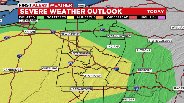
The second line of storms will slide through after 9 p.m. with places between I-70 and I-80 having the best chance for severe weather during that time.
Please remain weather aware this evening as these dangerous storms move through our region.
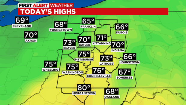
Before the storms arrive, the weather will be pleasant and dry with temperatures going from a low of around 50 degrees to temperatures near 70 at noon.
KDKA Meteorologist Ron Smiley has a broad area of rain moving through the area going into the afternoon. The rain could be fairly heavy and steady for more than an hour with the best chance of seeing the rain coming up along and north of I-80. Places like Morgantown may not see any rain as this initial round of rain arrives.
This round of rain should come to an end before 5 p.m for everyone.
Looking ahead, severe storms and rain showers behind the cold front should come to an end before the Wednesday morning rush gets going.
Highs will be in the upper 60s on Wednesday with pleasant conditions expected for most of the day.
Thursday and Friday highs will be near 70 as well with all-day rain now expected on Friday, continuing into Saturday.
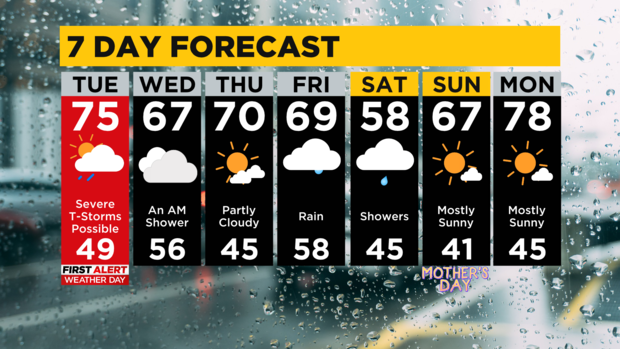
Saturday highs will dip to the upper 60s with morning lows in some places falling below 40 degrees.
Stay up to date with the KDKA Mobile App – which you can download here!