Another damp day is expected in the Pittsburgh area as Helene's remnants linger
PITTSBURGH (KDKA) -- It's going to be a damp day throughout the Pittsburgh area as remnants from Helene continue to linger around western Pennsylvania.
Any Alert Days Ahead? Not likely
Aware: Since last Thursday Pittsburgh has officially picked up just 0.35" of rain due to a dry easterly wind.
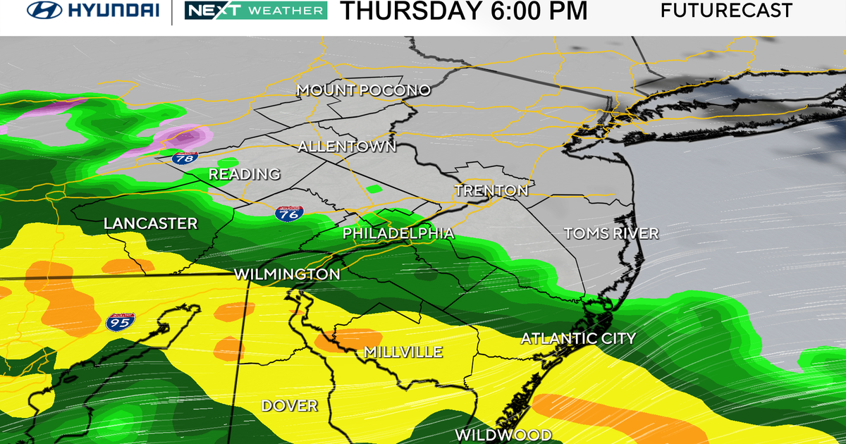
We probably didn't see as much rain as you think we did over the weekend. Officially at the Pittsburgh Airport, our 4-day total from Thursday through Sunday was just 0.35" of rain. Most of that (0.26") fell on Thursday. Friday to Sunday totals weren't even a tenth of an inch. Rain continues today with light showers possible throughout the day. The best chance for rain will come this afternoon but even this morning radar continues to indicate light rain showers. Rain totals today will likely be around a tenth of an inch to a quarter of an inch.
Nationally we continue to hear about the horrors of Helene well inland of the storm making landfall. As Helene was making landfall last week we talked about the broad 6-9 inches of rain being estimated by radar and how that would lead to widespread flooding. Unfortunately one of the worst-case scenarios occurred with this storm with now more than 100 people being confirmed dead by CBS News through this morning at 4 a.m. That is just an unimaginable loss of life. It will probably take years or even decades for these communities to fully recover from this.
Our week looks to be damp but we could certainly use more rain. The biggest issue for our region is the pesky easterly wind. When air lifts, it cools. Cool air cannot carry as much moisture as warm air. The moisture comes down in the form of drizzle on the eastern side of the Laurels. Once the air begins to sink to the west of the Laurels it is hotter than it was before it lifted. Sinking dry air warms around twice as fast as it cooled on the eastern side of the Laurels. This is a double whammy for us as we now have air that is hotter and drier than it started. This dry air acts to dry out our airmass that's already in place. What you see at the surface is rain totals that are far less than what model data indicated. This has been the case this entire weekend.
Looking at temperatures, highs today should hit the mid-60s with morning lows in the low 60s in most places. It will remain damp with overcast skies. Winds will be out of the east at around 5mph.
Tuesday and Wednesday highs will also be in the 60s with Tuesday looking very similar to today with rain showers around through the day. The rain finally comes to an end on Wednesday morning as a cool front pushes the remnants of Helene to our east.
WEATHER LINKS:
Current Conditions | School Closings & Delays | Submit Your Weather Photos