Pittsburgh Weather: Hurricane Ian remnants expected this weekend
PITTSBURGH (KDKA) - We won't need to batten down the hatches here but it looks like for the third year in a row Western Pennsylvania will be impacted by the remnants of some sort of tropical system.
Last year it was the remnants of Ida that brought rain to our area and big rain totals for places in the center of the state.
WEATHER LINKS:
Current Conditions | School Closings & Delays | Submit Your Weather Photos
In 2020, it was tropical storm Fay that brought flooding to our area.
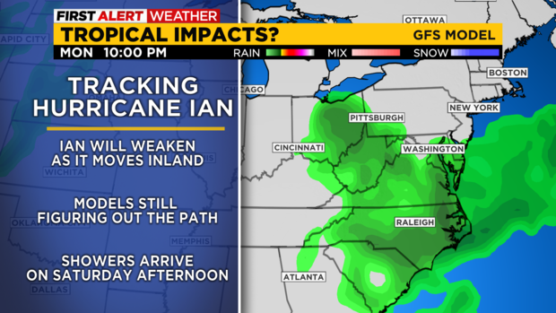
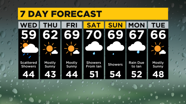
This year it is increasingly looking like we will see something coming from the remnants of Ian. Rain from Ian could arrive as early as Saturday afternoon. I have Ian bringing rain through Monday now for our region.
We also have a chance for rain today but it isn't due to Ian.
We continue to be under the influence of a large and broad area of low pressure that is centered just north of Quebec. This center of low pressure continues to push much colder air south.
Highs today will likely fail to hit 60 in most places.
Pittsburgh yesterday hit 59 degrees and I think we will be right there again today. The cold push of air also continues to cause just enough afternoon instability for us to see rain showers and occasional storms during the afternoon. Similar to yesterday, the peak chance for a passing shower or even a brief general thunderstorm will be from 2 p.m. - 6 p.m.
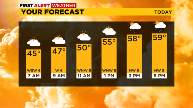
While you should expect mostly rain, some lightning will again be possible. Yesterday we also had small hail being reported in several areas as the showers rolled through. Morning lows today are back in the mid to low 40s.
Our dry spell now looks to only be Thursday and Friday with high temperatures steadily warming.
Thursday's highs should be in the low 60s with another cool start with morning lows in the mid to low 40s.
Friday will be just as cool to start the day with highs warming up to near 70. Things get a little crazy now for the weekend with rain chances arriving now on Saturday afternoon.
Rain totals of around a quarter of an inch to half an inch should be expected on Saturday.
Rain totals of more than half an inch should be expected on Sunday with Monday's rain totals possibly being as high as a full inch to two inches depending on location.
Stay up to date with the KDKA Mobile App – which you can download here!