Rain moving in to the Pittsburgh area by midweek. Will it be a drought buster?

PITTSBURGH (KDKA) -- Saturday's high of 86 degrees in Pittsburgh was just four degrees away from the record high of 90 degrees set in 1915 and 1952. The dry air that heated up quickly yesterday cooled off efficiently this morning resulting in most locations dropping into the mid-50s to near 60 degrees.
For Sunday, expect fairly similar conditions to yesterday with slightly less hazy skies. An easterly wind will result in most of us reaching the low- to mid-80s once again under mostly sunny skies and dry conditions.
Monday will also begin mostly sunny with some clouds moving in later in the day, but it will also continue to remain very dry.
Chances for precipitation this week are looking slightly better today compared to previous days.
The broad area of low pressure currently being monitored for potential tropical cyclone formation has shifted a little farther west and the latest models are trending slightly farther west with its track toward the Appalachians by Tuesday night into Wednesday. This system may strengthen into a low-grade tropical storm before making landfall along the NC/SC border, but whether it becomes tropical or not, rain will be the dominant impact.
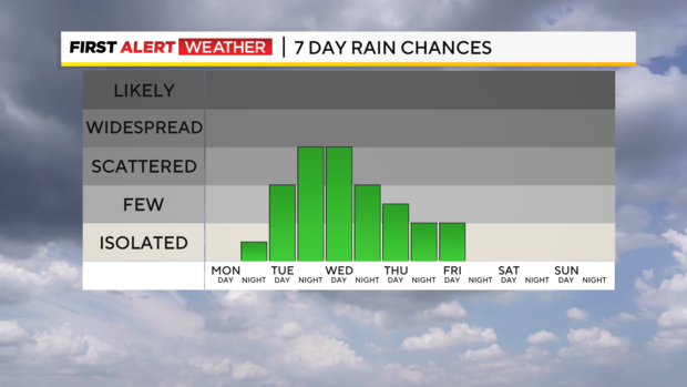
Here locally, showers will begin by midday to early afternoon Tuesday and become more numerous Tuesday night into Wednesday. Lingering showers are expected on Thursday before a reduction in clouds and drier conditions toward the end of the week. The highest rainfall amounts are trending toward the Laurel Highlands and Northern West Virginia with lower amounts from Pittsburgh and points west and north.
This will not be a drought busting rain, but at least we could end our current dry streak with some measurable precipitation. With the added moisture in the air along with enhanced cloud cover, high temperatures Tuesday through Thursday will likely be halted in the mid-70s while overnight lows increase to the low to mid-60s.
Dry air and the blocking high pressure are likely to return to the region as we head into next weekend.