Pittsburgh Weather: Highs soar to around 90s; storms, flooding possible into overnight hours
PITTSBURGH (KDKA) - We've been talking about it for almost a week now, so I don't know about you, but I am ready to get this hot stretch started.
Daily average High: 83 Low: 64
Sunrise: 6:12 a.m. Sunset: 8:42 p.m.
WEATHER LINKS:
Current Conditions | School Closings & Delays | Submit Your Weather Photos
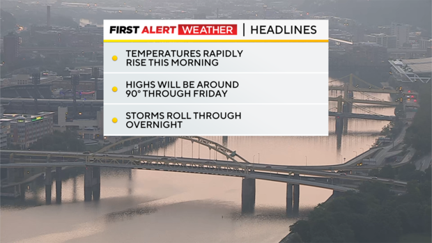
Today: Temperatures are set to soar, with morning lows in the 60s. 8 a.m. temps will be in the 70s. 10 a.m. temps will be in the 80s!
Any Alert Days Ahead?: We are highlighted for risk of severe weather on Thursday (10 p.m. Wednesday through 3 a.m. Thursday). Heat could also be enough to get a First Alert Day Thursday or Friday. We may have one for Thursday as soon as this morning.
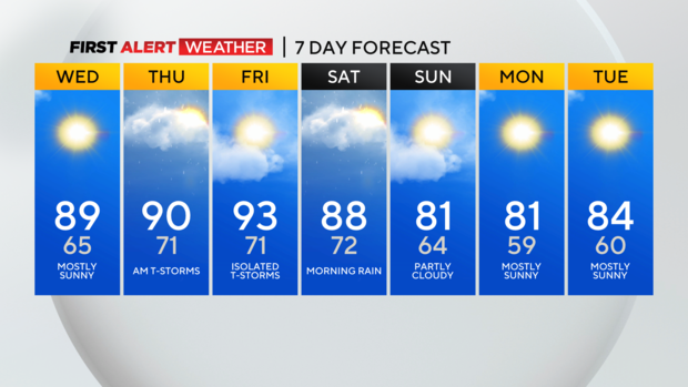
Aware: A heatwave is officially three 90° days, with temps never falling below 70° during the stretch. Right now, I am forecasting us just shy of 'heat wave' criteria with highs of just 89 today. If we hit 90 degrees, the chance of a heat wave happening goes up to over 70%.
Highs Wednesday will hit the 90s in a couple of places and will be close in many other communities. I think Pittsburgh will be in the close range.
I have Pittsburgh seeing a high of 89 degrees. Being that close, it could go either way. Our 850 temps for the afternoon should be around 18° C. That puts us in the 'either way' category. 850mb temps will climb to 19° C tomorrow, and data shows 850 temps of 23 on Friday. That makes us hitting the 90s almost a sure thing on Friday. That is some rare air for Pittsburgh and will fuel one of if not the hottest day of the year for us.
When it comes to local Pittsburgh climatology, we've only hit one 90° day so far this year. We average just over 10 days per year. Last year, we hit the 90s four times. The last time we saw numbers above the average was in 2020 when we hit the 90s seventeen times. That year we also saw nine straight days with highs at or above 90 degrees.
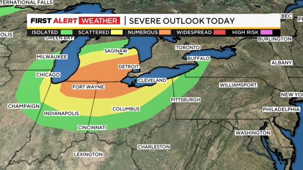
While the heat arrives today and sticks around through Friday, I don't want you to forget about potential storms expected overnight into Thursday.
While there is a severe weather chance, the flood risk is probably somewhat higher for most places. If we see severe storms, they would come due to strong straight-line winds. Lots of lightning with downpours should be expected.
These storms move through from 11 p.m. Wednesday through around 8 a.m. Thursday morning. The morning commute will be impacted for some.
Stay up to date with the KDKA Mobile App – which you can download here!