Pittsburgh Weather: High temperatures could reach into the 60s today

PITTSBURGH (KDKA) - It's the warmest start to February since 1991.
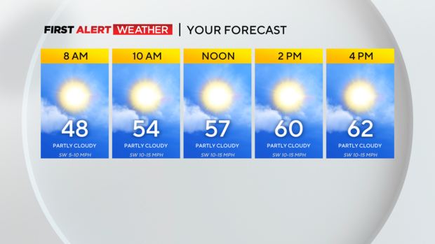
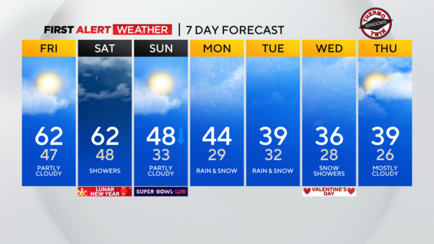
Warm air will remain in place through Saturday with highs today returning to the low 60s. We won't be anywhere near a record high with the record high for the day sitting at 70° hit all the way back in…Oh, last year.
WEATHER LINKS:
Current Conditions | School Closings & Delays | Submit Your Weather Photos
Morning temperatures are mild with most places dipping to the mid-40s. The best chance for rain for today has come and gone.
Saturday will see another chance for rain that arrives in the morning just after sunrise. The rain should stick around through at least 4 p.m. as a cold front slides through.
Rain will not be consistent and totals are only expected to be around a tenth of an inch. The day will be damp and overcast with light rain and pockets of drizzle.
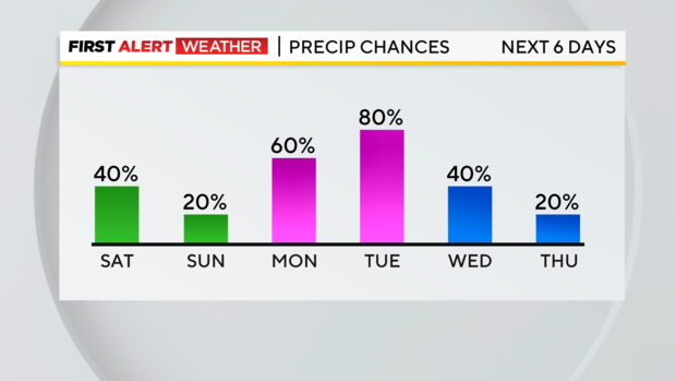
Even with the rain around I have Saturday's high hitting 62°.
Both Sunday and Monday look dry but I will keep an isolated (20% coverage) chance for rain in the forecast for both days.
The big system that we are keeping an eye on arrives on Tuesday.
Model data is jumping on this being a big snowmaker but there are tell-tell signs that this will be rain and snow mixed with nothing more than moderate impacts on area drivers.
We are still several days out so we will keep you updated with what you need to know about it throughout the weekend.
Stay up to date with the KDKA Mobile App – which you can download here!