Pittsburgh Weather: Haze is back along with warmth
PITTSBURGH (KDKA) - The next chance for rain arrives on Friday evening, but most will be dry until Saturday morning. Model data is not consistent on the timing of the front moving through
WEATHER LINKS:
Current Conditions | School Closings & Delays | Submit Your Weather Photos
The biggest thing to note about our weather forecast today is that something happening on the ground will impact our skies throughout the day.
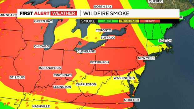
I expect a fairly thick haze to be in place today due to wildfire smoke drifting by.
Now before today, the smoke was mainly from the Edmonton, Canada region but that is no longer the case today. Smoke from there, merging with smoke coming from Minnesota and the Dakotas, will drift by throughout today. This will lead to mostly hazy skies.
The good news is that our air quality at the surface will not be impacted by the smoke passing by.
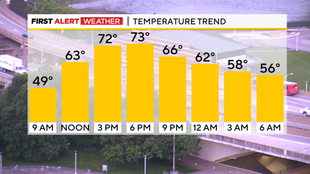
Besides smoke moving by, today will be a pretty normal day. I have Pittsburgh hitting 73° for today's high. That's just a degree off of the normal high of 72° for today. It is a chilly start though to our day with temperatures dropping to the mid to upper 30s for morning lows.
The good news is that for most, meager dew points will keep us from seeing widespread frost. That's the reason for no frost advisory being issued for a big portion of our area. We do have frost advisories in place for the Laurel Highlands and freeze warnings posted for both Venango and Clarion Counties.
Temperatures will warm quickly today with temps in the mid-50s by 10 a.m.
Low to mid-60s by noon too. Enjoy.
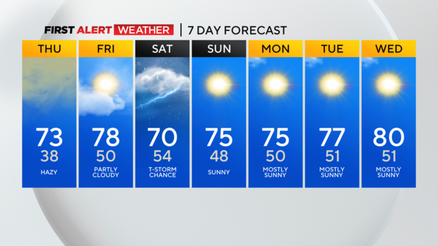
Finally looking at the workweek there are two things to point out. The first is that our next rain chance will arrive on Friday evening with most having to wait until Saturday to see any rain.
Right now model data on Saturday isn't consistent. The trend is rain sliding in later than originally thought. I have added in a storm chance for the afternoon but my confidence there is low due to no consistency both run-to-run and model-to-model with what to expect.
The second thing I wanted to mention was a big warm-up that arrives next week.
Highs beginning on Wednesday should return to the 80s with a big ridge of high pressure moving in.
The warmth could last through Memorial Day!
Stay up to date with the KDKA Mobile App – which you can download here!