Pittsburgh Weather: Dry and sunny Tuesday, one of hottest stretches of year beginning Wednesday
PITTSBURGH (KDKA) - There is a lot of uncertainty with my forecast due to rain chances late this week.
Daily average High: 83 Low: 64
Sunrise: 6:11 a.m. Sunset: 8:43 p.m.
WEATHER LINKS:
Current Conditions | School Closings & Delays | Submit Your Weather Photos
Today: The best chance for rain has already come and gone. Tuesday will be pretty typical for this time of the year, with highs in the mid to low 80s.
Any Alert Days Ahead?: We are highlighted for risk of severe weather on Thursday. Heat could also be enough to get a First Alert Weather Day Thursday or Friday. We may have one for Thursday as soon as Tuesday morning.
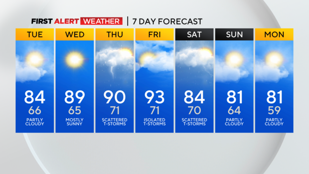
Aware: Heatwave is officially three 90-degree days with temps never falling below 70 during the stretch. Right now, I am forecasting us just shy of 'heat wave' criteria with highs of just 89 on Wednesday.
What has all the makings of being one of the hottest stretches of weather for the year could be 'cooled' by rain chances.
Yesterday, rain chances looked like a sure thing for Friday night into Saturday. And while there will be a chance for rain during that time, severe weather could also impact the region early on Thursday morning. My confidence in the rain at this point for the back half of the week into the weekend is low. There will be rain around, but timing and just how much is still in limbo.
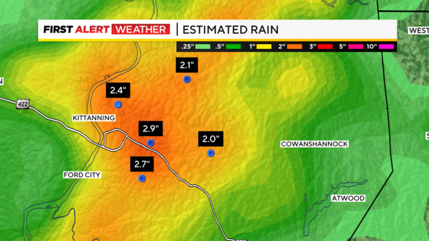
For today, the best chance for rain has now come and gone. The cluster of non-severe storms rolled through from around 2:30 a.m. through 6:30 a.m. Many may have slept through the storms. Radar estimates of rain were in the two-to-three-inch range in the Kittaning area. There were spots in Pittsburgh that approached an inch of rain, including Millvale, Etna, and Lawrenceville. The cut-off for data for this week's drought maps occurs this morning at 8 a.m., so this rain will be part of what looks like a big week of rain that should really end most drought conditions in the region.
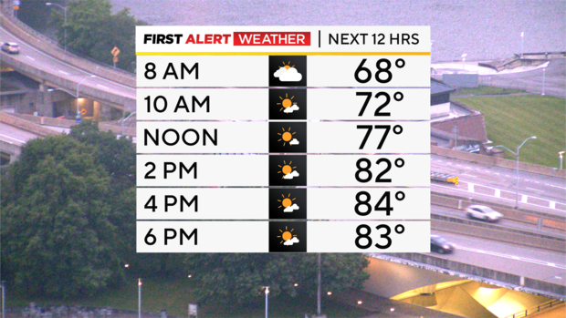
Highs today will hit the mid-80s, with mostly sunny afternoon skies expected. I have noon temperatures in the upper 70s. Winds will be light and out of the west at around 5 mph.
The big story for the week continues to be just how hot it will get from Wednesday into Friday. I have Wednesday's high hitting 89 degrees. Highs on Thursday hitting 90, with the morning storm chance, and then a high of 93 is now forecast for Friday.
Stay up to date with the KDKA Mobile App – which you can download here!