Pittsburgh Weather: Dry conditions Monday ahead of rain and snow chances

PITTSBURGH (KDKA) -- Today will be dry in Pittsburgh, but rain and snow showers roll in tomorrow afternoon.
Today: Chilly with partly to mostly cloudy skies. While data was hinting at lake effect snow nothing is showing up right now on radar and the best chance has now passed
Any Alert Days Ahead? Probably not. Decent snow is expected to fall for the Laurels on Tuesday and Wednesday but not much is expected to stick. Could see some icy roads though in higher elevations. It turns cold for this time of the year for the upcoming weekend and Light Up Night.
Aware: The freeze returns for the weekend with highs not forecast to get over the freezing mark.
There will be a rain or snow chance all the way through Thursday depending on your location. And then temperatures turn VERY cold this weekend. Make sure those furnaces are ready for the winter.
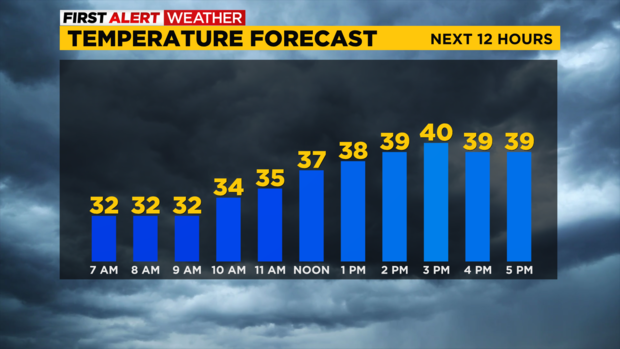
For today, skies will be partly to mostly cloudy. Morning lows are hovering around 32 in Pittsburgh with most places seeing their temps in the upper 20s this morning. Highs today will be near 40 so it will be a little cooler than yesterday. I have today's high at 40 degrees with noon temperatures in the upper 30s. Winds are light enough that wind chills won't be more than a degree or two from the actual temperature. They'll be out of the north northwest when they do register.
Rain and snow arrive on Tuesday afternoon, probably just after 2 p.m. in Pittsburgh. What will be rain for Pittsburgh and most of the area, will be snow for the Ridges and Laurel Highlands.
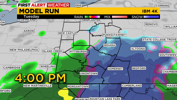
Most of the rain and snow with this first round will be out of here by around 5 to 6 p.m.
We get round two of precipitation on Wednesday morning. There will be a better chance for snow with this round in places that aren't elevated. Most of the rain will be out of here by the time the Wednesday morning rush gets really going.
While the previous paragraph is what you should expect, I just want to quickly write a disclaimer. I know it is my 'get out of free' card just in case but yes like with any forecast there is some uncertainty about what may happen. In this case, one of my favorite data points shows most if not all of the precipitation sliding through on Tuesday and Wednesday as snow. Here's the thing, I don't think historically this type of set-up brings with it the snow the model is trying to jump on.
If I am off and instead of mostly rain we get snow we will also be fine as road temperatures are WELL over 32 right now. Even the snow in the Laurel Highlands that we are expecting should be only a minor inconvenience to drivers on both Tuesday and Wednesday.
Finally, once the rain and snow chances move out of here late on Thursday we turn brutally cold for the weekend. At least for this time of the year.
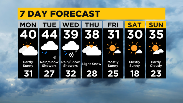
Highs on Friday and Saturday are only expected to hit the low 30s with morning lows easily dipping into the low 20s and even teens being possible on Saturday morning. Brrrrrr. Be prepared.
WEATHER LINKS:
Current Conditions | School Closings & Delays | Submit Your Weather Photos