Pittsburgh Weather: Cooler temperatures remain, light rain chances possible
PITTSBURGH (KDKA) - When comparing today to yesterday, the morning will be cooler.
- Daily average High: 71 Low: 51
- Sunrise: 7:13a Sunset: 7:10p
Today: Low rain chance. A cool start and day… Breezy.
Any Alert Days Ahead?: Nope.
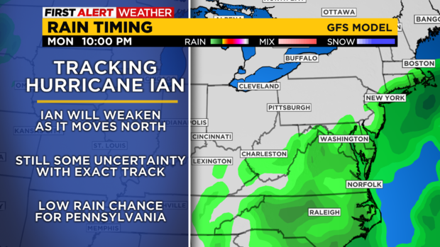
Aware: Temperatures will warm for the weekend. At this point, it appears we get no rain from Ian.
WEATHER LINKS:
Current Conditions | School Closings & Delays | Submit Your Weather Photos
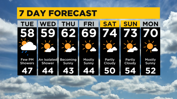
The afternoon will be similar even with temperatures around ten degrees cooler today than what we saw yesterday. Highs today will likely hit the upper 50s in most places, with one or two places possibly hitting 60. Similar to yesterday, a light passing shower chance will peak during the afternoon hours. The skies will be partly cloudy. Winds are gusty and out of the west at 12-17 mph.
Looking ahead, I will maintain an isolated chance for rain on Wednesday before we start a dry stretch of weather. Temperatures will remain cool through Thursday with highs near 60 on both Wednesday and Thursday. We then see highs back near 70 degrees on Friday with near seasonal weather expected over the next week as we roll into October.
For those wondering about any potential impact from Ian, if we see anything it would come in the way of some light rain on Sunday morning. Most data at this time is keeping us completely dry.
Obviously the farther to the south you are the higher the chance of seeing rain from what is now Hurricane Ian. Hurricane Ian is currently a major hurricane (Cat 3 or higher) with 110 mph winds. Ian is, as of 4a this morning, located right over western Cuba and is moving at around 13 mph to the north northwest. Ian is currently forecast to be a Cat 2 hurricane as it makes landfall somewhere along the Florida coastline near Tampa Bay.
The biggest impact will be a strong storm surge along with inland flooding. Heavy rain will also help exasperate issues with flooding. Landfall is expected to occur Thursday morning. The current track brings Ian over southeastern Georgia by Friday night. Ian could possibly be located along the North Carolina and South Carolina state lines on Saturday night.
Stay up to date with the KDKA Mobile App – which you can download here!
