Pittsburgh Weather: Chilly again today, frost possible Wednesday morning
PITTSBURGH (KDKA) - A freeze warning has been issued for portions of northwest, southwest, and western Pennsylvania as well as portions of northern West Virginia, per the National Weather Service.
Additionally, a frost advisory has been issued for portions of southwest and western Pennsylvania and the northern panhandle of West Virginia.
The freeze warning and frost advisory go into effect at midnight Wednesday through 9 a.m. Wednesday.
Full forecast below.
Here's one for the procrastinators. Have you been one of those people watching and admiring the gusto that your neighbors have shown when it comes to planting pretty plants around your home?
- Daily average High: 64 Low: 42
- Sunrise: 6:38 Sunset: 8:03
Today: Day two of cold weather. Light rain and snow have wrapped up for most of the viewing area. It will remain windy, though.
Any Alert Days Ahead?: One could argue for a FAWD due to frost on Wednesday morning. Next Monday, frost is possible, but it looks like cloud cover would limit it.
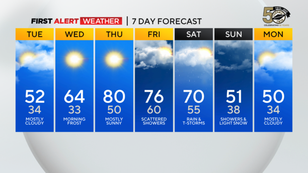
Aware: Temps will be back to the 60s on Wednesday and near 80 on Thursday
Stay up to date with the KDKA Mobile App – which you can download here!
Well, overnights like what we are about to see are the reason you are supposed to wait, as frost overnight conditions could impact the health of a lot of those plants that are just now starting to bloom. If you have already planted, there are a couple of simple things that you can do to limit the impact of the overnight chill, including bringing plants in, covering plants, and even spraying the plants with a light glaze of water before heading to bed.
For everyone else? Well, there is also an outside chance for frost next week too, so it looks like we won't be planting for another month or so.
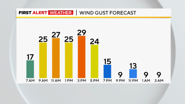
Let's circle back to Tuesday's weather, which won't be nearly as nasty as yesterday's weather. The rain and snow have wrapped up for most, with everyone dry for the afternoon. Winds will remain strong, coming out of the west at 10-20 mph. Skies will be cloudy before noon and partly cloudy for the afternoon. I have temperatures in the mid to upper 30s this morning, mid to low 40s at noon, and in the low 50s as the kids are getting out of school.
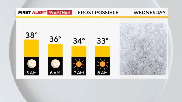
Cloud cover and strong winds are the reason that Tuesday is not optimal for frost, unlike Wednesday morning when skies are expected to be crystal clear and winds light.
Looking ahead, a warm front should move through dry on Wednesday morning around 8 a.m., with temperatures rapidly rising for the rest of the day. Highs on Wednesday should hit the mid-60s.
Thursday highs will be right at or just above 80 degrees. The weekend isn't looking great, but Friday should be fantastic up until around 6 p.m. when the rain returns. Friday highs will be in the mid to upper 70s. Saturday highs will be in the low 70s, with a powerful cold front bringing an evening to afternoon storm chance. Sunday and Monday will see highs near 50 and some very cold mornings.
WEATHER LINKS:
Current Conditions | School Closings & Delays | Submit Your Weather Photos