Pittsburgh Weather: A partly cloudy Tuesday with hints of sunshine
PITTSBURGH (KDKA) - Finally, the sunshine is back today and tomorrow! Enjoy it while it lasts.
- Daily average High: 39° Low: 26°
- Sunrise: 7:40 a.m. Sunset: 4:57 p.m.
FIRST ALERT: Friday for rain switching over to snow impacting holiday travel. Saturday for unfavorable wind chills all day.
AWARE: Bitter cold temperatures this weekend. Highs in the teens and lows in the single digits. Wind chills are in the negatives during morning hours.
WEATHER LINKS:
Current Conditions | School Closings & Delays | Submit Your Weather Photos
Afternoon highs will be in the mid to upper 30s today then low 40s tomorrow! Morning lows will be in the low 20s, so it'll still feel chilly. Wednesday is the first official day of winter, and we'll be about on average with the temperatures.
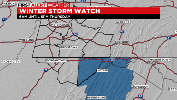
We will see moisture lifting into the area Thursday. The onset of this precipitation will be a mix in many spots thanks to the warm front, but there could be some freezing rain in the ridges. That is why the National Weather Service has a winter storm watch in play for Garrett County on Thursday. This particular winter storm watch is only for the freezing rain potential Thursday.
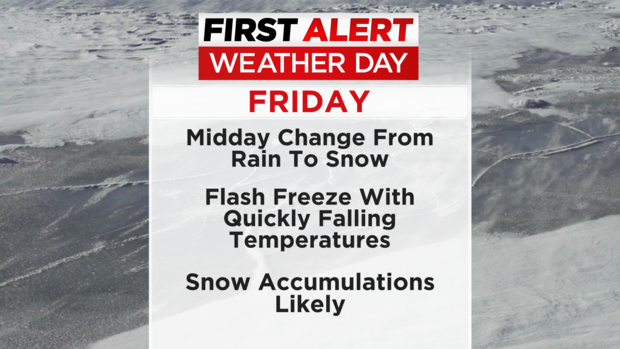
First Alert Weather Day is set for Friday. Winds pick up to possibly 50 mph gusts. Rain starts in the early morning for everyone then switches to snow by the late morning.
Snow will begin to accumulate Friday. That rain will hinder snow totals though, so there are still no exact numbers on that yet. Any snow that sticks to the ground should last through Christmas Day. Temperatures plummet throughout the day from the 30s/40s down to the teens/single digits. So given that setup, flash freezing will likely happen Friday afternoon from the wet areas turning to slick ice. So, please be very careful if you are headed out Friday for any holiday travel!
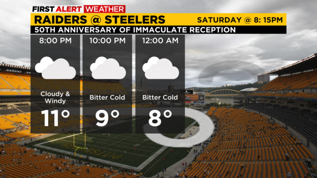
Christmas weekend will be unseasonably cold. First Alert Weather Day was issued for Saturday because it'll still be very windy and light snow eventually tapers off throughout the day. Morning temps will be in the single digits/teens but wind chills will be between 0 and -20°. Afternoon highs will only be in the teens with wind chills still in the negatives since winds could still be gusty up to 45 mph.
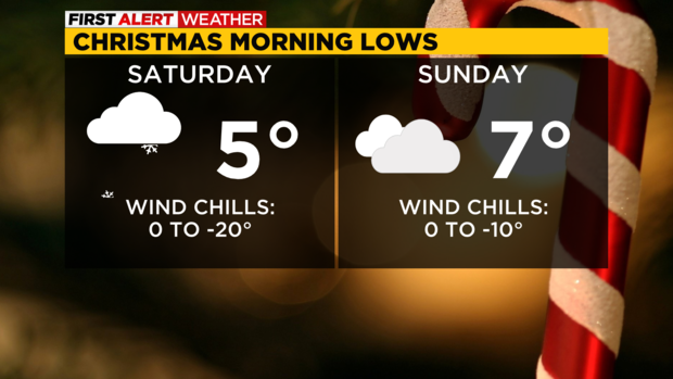
On Christmas Day, it'll be cloudy with winds calming down but still a bit breezy. Morning temps will be in the single digits with negative wind chills then afternoon highs in the mid-teens. So, dress in lots of extra layers if you have to be outside this weekend or move any outdoor plans indoors!
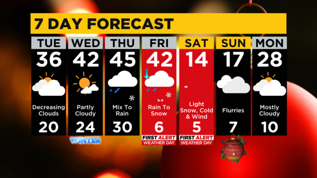
Temperatures will start to come back up next week as we exit the deep freeze.
Stay up to date with the KDKA Mobile App – which you can download here!