The warm temperatures and sunshine stick around for a couple more days in Pittsburgh

PITTSBURGH (KDKA) - A large ridge of high pressure continues to influence our weather pattern across the Ohio River Valley this weekend and into the start of the upcoming week.
This means a persistent forecast of mostly sunny, warm afternoons and clear overnights with areas of river and valley fog developing around sunrise.
WEATHER LINKS:
Current Conditions | School Closings & Delays | Submit Your Weather Photos
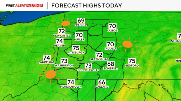
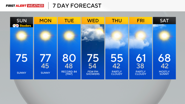
Today, we anticipate highs to be around 2-3 degrees warmer compared to Saturday after a chilly start with some areas of river fog. Any fog that is in place should mix out by 9-10 a.m. Highs will reach the low to mid-70s.
There is also an Air Quality Alert for Allegheny County, specifically for the Liberty and Clairton areas.
Air pollution concentrations could be high enough to cause problems for sensitive groups, especially during the early morning to midday hours where an inversion will prevent the air from mixing. A slight breeze may help to alleviate this by early afternoon and evening.
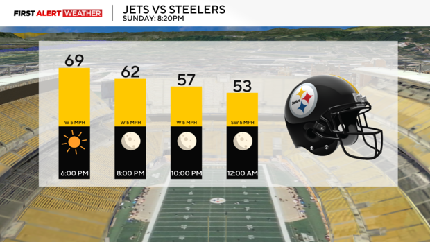
For those headed to the Steeler game, expect dry and comfortable conditions—quite the difference compared to the last primetime game a couple of weeks ago.
The stretch of unseasonable warmth and dry conditions will continue through the first half of next week. Monday will feature highs in the mid to upper 70s and Tuesday will likely feature highs close to 80 degrees. Tuesday's record high is 84 degrees set in 1947, so while we will likely come up a few degrees short of that, this is still something to note how far we will be deviating from what should be normal this time of year.
Our next opportunity for a few showers will not arrive until next Wednesday into Thursday with a cold front passing through the region. Moisture looks limited with this system, so coverage and rainfall amounts do not look great.
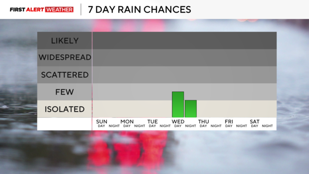
This is definitely a problem as drought conditions continue to persist across our region and will likely intensify the longer we go with consistent, heavy precipitation. A brief cooldown will follow the cold front on Thursday, but temperatures are expected to spike back to unseasonable levels by the end of the week.
Stay up to date with the KDKA Mobile App – which you can download here!