Pittsburgh starts Friday with rain and then those turn into overnight storms

PITTSBURGH (KDKA) - Rain and storms are expected today across our region and there is a chance for severe weather with straight-line winds the main concern.
Today we will see a warm front sweep through our area, bringing with it the chance for morning rain. Instability will settle in behind the warm front with scattered storms expected to develop this afternoon.
WEATHER LINKS:
Current Conditions | School Closings & Delays | Submit Your Weather Photos
Storm chances will stretch into the overnight hours as a secondary boundary will sweep through. There remains uncertainty when it comes to the timing out afternoon to overnight storms.
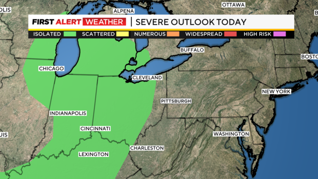
While there is uncertainty when it comes to timing, storm type is a little less uncertain. If we see severe weather it would likely be due to strong straight-line wind speeds greater than 58mph. The risk of large hail and or a tornado will be very low today. Frequent lightning and a couple of big booms should also be expected with any storms in the overnight hours.
The timing of storms will be from 4 p.m. through 2 a.m. It is a fairly broad window for today.
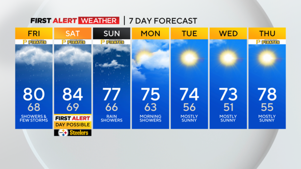
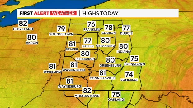
With rain around this morning, I've dropped our high-temperature forecast to just 80 degrees. Morning temperatures are way up this morning with most places seeing morning temperatures above 65°. It is by far the warmest start of the week. Our next cool morning will likely be on Tuesday of next week.
Saturday still seems to be the day with the highest storm chance.
If we see strong storms on Saturday, it'll happen in the afternoon and evening. Saturday will be the typical storm day where the strength of our afternoon storms will be controlled by just how hot surface temperatures get.
Everything else is in place for strong storms on Saturday. Clouds will be our friend in limiting any impact from storms. I still have our highs hitting the mid-80s on Saturday with stormy conditions being possible.
Data still shows a chance that strong storms will have an impact on the Steelers game with potential severe weather occurring around the time folks are in the stadium.
Please be weather-aware.
Sunday's rain chance should be highest before noon. I have Sunday highs hitting the mid to upper 70s.
Monday will also see an isolated rain chance with highs in the mid-70s. Tuesday of next week looks to be the coolest of the week.
I have highs only hitting 70 in Pittsburgh.