Pittsburgh expecting snow overnight into Thursday. Here's what you need to know to be prepared
PITTSBURGH (KDKA) - So this is going to be a technical post. I apologize ahead of time for that.
WEATHER LINKS:
Current Conditions | School Closings & Delays | Submit Your Weather Photos
These types of posts are never easy to read but go a long way toward being the "go back and check what I said" record for those internet lingerers who like to try to get us on "gotchas."
So let's get right to it.
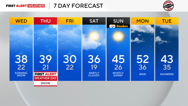
- What's Going On: An upper low will push another blast of arctic air our way on Thursday, Dec 5th. We will see a decent amount of snow overnight ahead of the colder air.
You could argue round two begins after that with windy and cold conditions moving in for the remainder of Thursday into Friday. When it comes to accumulating snow some places may see most of their snow happen during this 'second event'. - How Much Snow Should I Expect?: Snow totals probably aren't going to be as big as you would expect and the impact of this storm isn't just because of the snow. There's also a difference in what falls versus what is on the ground. So if you are south of I-80 but not in the 'Snow Belt' of Northern Butler, Armstrong, & Indiana County along with elevated areas, expect around an inch of snow on grassy areas as you wake up Thursday morning. Snow Belt areas should expect to see 3-5 inches of snow on grassy areas along with an inch or more of snow on hard surfaces. The Laurel Highlands will see up to 9 inches of snow in spots. There could be isolated places there that see even more!
- So Snow Is The Biggest Concern?: Not entirely true. Yes, we will see snow and in some spots, the snow will be significant. But that tells only part of the overall story. Snow along with winds and a cold airmass will make conditions just miserable for those stuck outside.
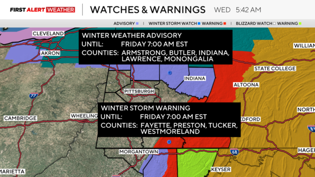
- How Long Does This Last? While we will see consistent snow overnight, strong winds and cold temps will be around all day on Thursday into Friday. The Winter Storm Warning for the Laurel Highlands & Ridges goes through 1p on Friday. Winter Weather Advisories go through 7a on Friday. I expect the worst conditions to happen from 3a to noon on Thursday.
Back to today, it's cold once again with morning temperatures in the mid-20s.
Afternoon temperatures will be very similar to what we saw yesterday with temps in the mid-30s. We won't cool down tonight ahead of the cold front with temperatures remaining in the mid to upper 30s through 2 a.m. and then rapidly dropping from there.
Stay up to date with the KDKA Mobile App – which you can download here!
