Clouds and rain showers linger around the Pittsburgh area until about mid-week
PITTSBURGH (KDKA) - We continue to deal with the remnants of Hurricane Helene that have merged with an upper-level low over the Ohio River Valley this Sunday morning.
WEATHER LINKS:
Current Conditions | School Closings & Delays | Submit Your Weather Photos
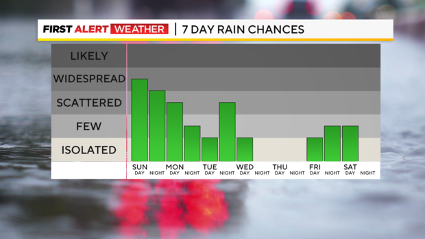
While all the tropical characteristics of this system are gone, this slow-moving area of low pressure and its fetch of Gulf of Mexico and Atlantic moisture will continue to keep persistent rain chances and plenty of cloud cover in place for the first half of this week.
For Sunday, expect numerous to widespread areas of rain virtually all day.
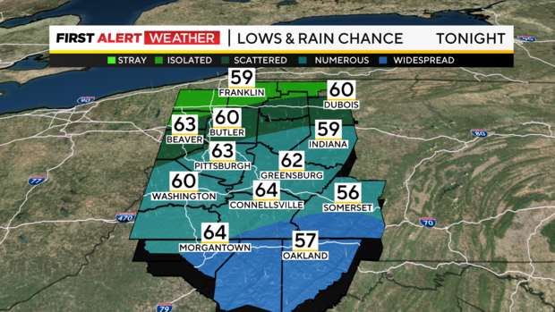
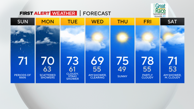
The highest coverage during the daytime hours will be between I-70 and I-80 in much of western PA. Overnight into Monday, most of the widespread rain will shift south toward I-70 and I-68 with lingering areas of light rain or drizzle across the rest of our area. Winds will be fairly light, but consistent out of the east and temperatures will remain fairly constant with highs each day through Tuesday in the mid-60s to lower 70s and lows in the lower 60s.
Total rainfall amounts will range from 0.25" to 0.5" in spots, with locally higher amounts of 0.75" to 1" in the Laurel Highlands.
We will finally see an end to this cloudy, dreary stretch by Wednesday as a cold front moves into the region by mid-morning.
Following this front will be a drier air mass from the Midwest along with slightly cooler temperatures. Daytime highs won't vary too much. They are cooler behind the front, but the drier air should at least allow for more seasonal overnight lows by Thursday morning.
This will be a brief shot of cooler air as west-to-southwest winds will quickly return on Friday as high pressure moves to our east. As a result, highs will quickly soar back above average by 10 degrees or so ahead of another weak weather system and its associated cold front. This may bring another chance of scattered showers or a thunderstorm Friday night into Saturday morning.
Stay up to date with the KDKA Mobile App – which you can download here!