Pittsburgh expecting cooler and more comfortable conditions to close out the weekend
By: KDKA First Alert Meteorologist Carl Lam
PITTSBURGH (KDKA) - The big question from everyone about Saturday is "What happened?!"
The best analogy to describe it is showing up to a cookout with your friends, everyone brought the food to cook and brought in the grill, but the host forgot the propane/charcoal.
All the ingredients were there to make for a potentially active day, but the sun never got the storms bubbling up, due to the cloud cover.
If we had even an hour's worth of full sunshine, the setup would have been completely different!
WEATHER LINKS:
Current Conditions | School Closings & Delays | Submit Your Weather Photos
Onto better news, there is some rain moving through this Sunday morning that is just ahead of the cold front that will swing through this afternoon. Once the cold front does move through, the humidity will gradually decrease, with the help of a northwesterly wind.
Ultimately, it will feel better this afternoon around Pittsburgh with less humidity and more comfortable temperatures. Those that had rescheduled events for today will have a much more comfortable and enjoyable day overall without the threat of potentially active weather.
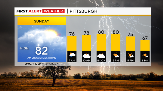
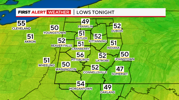
Once we head into the evening, some cooler air will start to settle in and it will be great sleeping weather tonight. You'll be able to give your air conditioners and fans a bit of a break as temperatures tonight will drop into the mid-50s around Pittsburgh and the airport and areas in the suburbs will drop into the low 50s.
It may actually be a bit too cool for some to open the windows tonight!
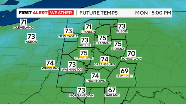
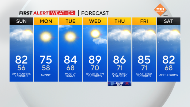
Monday promises to be a spectacular day. It will be a cooler start but we will warm up nicely into the afternoon as temperatures will climb into the low to mid-70s. There will be plenty of sunshine for you to enjoy and the humidity will be very low. If you are fortunate enough to have some time off this holiday week, enjoy Monday because it is the coolest day in the extended forecast.
By Tuesday, conditions are still quite comfortable and we'll have a decent amount of sunshine around Pittsburgh but the humidity starts to creep back in during the afternoon. So by Tuesday evening, the overnight lows are only dropping back into the low to upper 60s across the entire region. This is a sign that the short lived break from the heat and humidity are coming to an end.
We are headed back into the heat and humidity on Wednesday. There is the potential that we make a run at 90° on Wednesday with the chance for rain showers and thunderstorms later in the day and after sunset. As we look ahead to Independence Day, there will be some chances for rain and isolated thunderstorms with temperatures still in the mid to upper 80s and that trend continues into the weekend.
Stay up to date with the KDKA Mobile App – which you can download here!