Pittsburgh bracing for rain, thunderstorms, and potential severe weather today
By: KDKA First Alert Meteorologist Carl Lam
PITTSBURGH (KDKA) - Here we go again! It is another KDKA First Alert Weather Day and there will definitely be impacts felt across the entire region today from Franklin and Brookville, through Downtown Pittsburgh, to Waynesburg and Cheat Lake.
WEATHER LINKS:
Current Conditions | School Closings & Delays | Submit Your Weather Photos
Once you walk out the door to enjoy your Saturday, the first thing you'll notice is how humid it is...again.
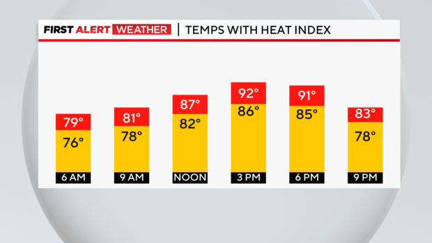
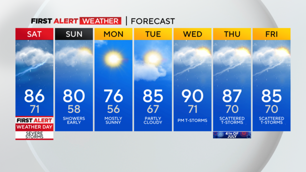
The heat will slowly build throughout the day and most areas will climb into the low 80s in the suburbs and into the mid-80s out at the airport. When you factor in the humidity today, it will feel like the low to mid-90s, so another sticky day is on the way.
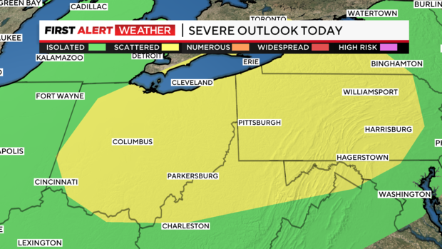
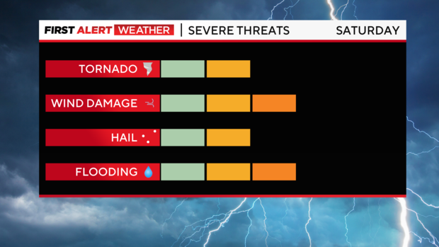
We have quite the setup today across Western Pennsylvania and Northern West Virginia for some severe weather to develop. The Storm Prediction Center has our region pegged at a scattered chance for severe weather. Our entire viewing area, shaded in yellow, can expect some strong storms through the afternoon and into the early evening.
The main threats are rain, thunder, lightning, gusty winds, hail, and the chance for tornadoes too. The strongest of the storms will be here from noon until 9 p.m., basically as long the sun is up, the chances for active weather remain elevated.
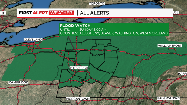
There is also a Flood Watch in place for areas like Indiana, Mercer, Allegheny, Beaver, Washington, Butler, and Armstrong Counties until 2 a.m. Sunday. With all the rain expected today, this may lead to some localized flooding in some areas, especially those places that are prone to flooding.
Once we get through today and the active weather, there's still some leftover rain possible for early Sunday. Most of the rain should wrap up by about noon. Cooler conditions are on the way once the cold front slides through...and you'll notice it as the humidity decreases and the temperatures cool off for Monday and Tuesday. Unsettled weather pattern returns for Wednesday and even the holiday on Thursday.
Stay up to date with the KDKA Mobile App – which you can download here!