Fall weather will be settling in today throughout the Pittsburgh area
PITTSBURGH (KDKA) -- Fall weather will be settling in today throughout the Pittsburgh area.
Any Alert Days Ahead? Chance on Friday morning due to frost from Butler to the north.
Aware: Record rain fell at the Pittsburgh airport yesterday with us recording 1.07" of rain.
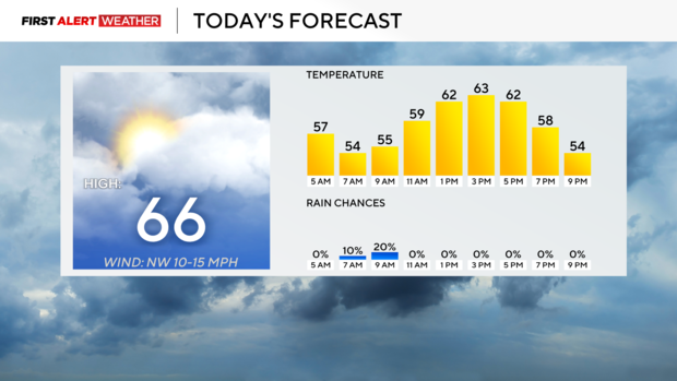
Who's ready for fall y'all? We've already seen our high-temperature today coming in at 66 degrees at midnight.
We will get back to the low 60s this afternoon with our daily low occurring just before midnight tonight. I have our low set at 48 degrees today. We should drop all the way down to the mid-40s for Tuesday morning's low.
Today's weather is just going to be sorta 'meh'. Perfect for a Monday morning after a tough Steelers loss.
Most of the day will see sunshine but there will be a few hours from around 10a through around 3p where skies will be mostly cloudy to overcast. I also can't rule out a passing shower or two during the morning hours with the chance highest for those north of I-80. Any rain would come off of Lake Erie and be due to the cold air running over much warmer lake water. Technically any rain we see would be lake-effect rain showers.
Looking ahead, our next rain chance doesn't arrive until Sunday and at this time I am keeping that at just isolated. Temperatures will remain in the 60s for highs through Friday. Morning temperatures will hover near 40 degrees and we could see some frost advisories even being issued this week.
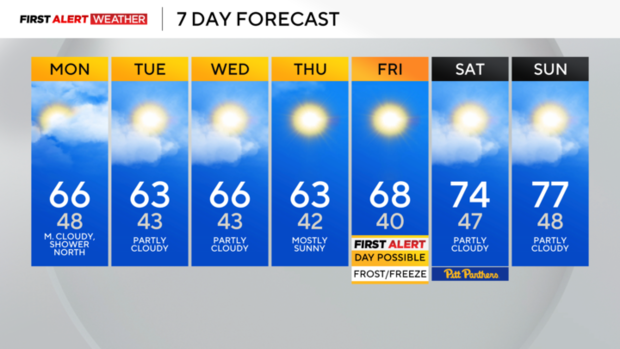
The coldest morning of the week will be on Friday morning where I have our low in Pittsburgh dipping to 40°. Anywhere from Butler to the north will have the chance of seeing frost advisories issued on Friday morning.
Nationally the big story is Milton, a category 1 hurricane as of the 4 a.m. Monday update. The storm is currently forecast to slam into Tampa Bay late Wednesday as a powerful Category 4 storm.
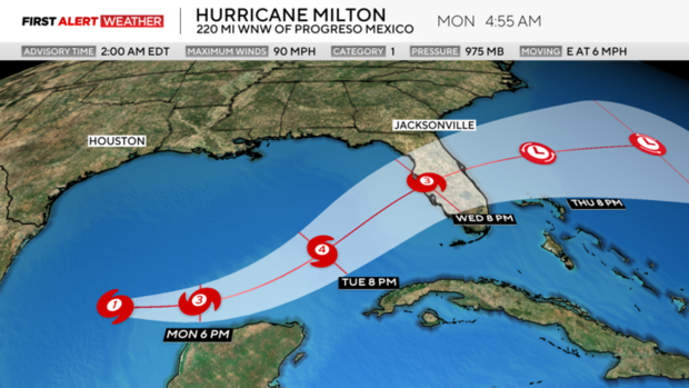
While there are many concerns, the biggest concern at this point is with a devastating storm surge along with inland flooding as the storm travels from the southwest to the northeast across the Florida Peninsula. Evacuations are ongoing and the first hurricane watches will be issued across the coast at some point this morning.
WEATHER LINKS:
Current Conditions | School Closings & Delays | Submit Your Weather Photos