Pittsburgh area set for intense heat wave as new week begins
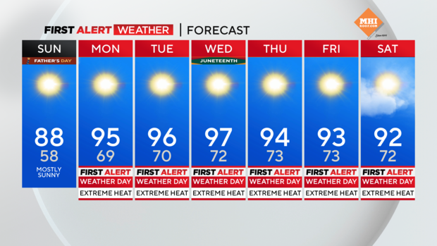
PITTSBURGH (KDKA) -- After a gorgeous day on Saturday, highs on Sunday will hit the upper 80s and head to the 90s starting Monday.
Alert: Starting Monday, we are going to keep First Alert Weather Days in place for as long as the heat wave continues. This means highs hitting 90 degrees, with temperatures remaining over 70° the entire time. The heat wave will likely stretch from Monday to next Sunday.
Aware: Expecting the heat wave to last seven days.
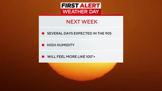
We could hit the upper 90s, and urban areas may get close to triple digits, but the mid-90s are a sure bet, at least for most of this week.
We haven't seen this type of heat wave since 1988, and the NWS has only issued three excessive heat watches since 2011. The last was in July 2019.
Monday's high record sits at 95, and most records this week are at 95 and 97 degrees, so we will be in the ballpark for potential record high temps.
Overnight lows will not give us any relief, as they will not dip below 70 degrees. Humidity will also be a factor mid to late next week, so please have a plan to access a cool place, stay hydrated, wear light clothing, and do not overexert yourself during peak heating hours.
An excessive heat watch will be in effect starting Monday morning. This 'watch' goes through Friday, and will likely become a warning as we get closer. An excessive heat watch is issued anytime heat index values are expected to hit 100 degrees or higher.
WEATHER LINKS:
Current Conditions | School Closings & Delays | Submit Your Weather Photos