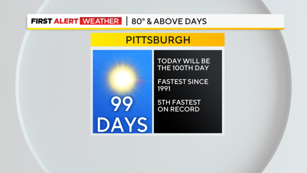
Friday marks the 100th day this year of Pittsburgh seeing temperatures in the 80s or higher
PITTSBURGH (KDKA) - Today will be the 100th day of the year with Pittsburgh seeing a high of at least 80°. Records spanning back to 1871 show this to be the fifth fastest on record and the quickest we have hit this mark since 1991 and 1991 stands as the quickest we have ever hit the 100-day mark.
WEATHER LINKS:
Current Conditions | School Closings & Delays | Submit Your Weather Photos
The next three on the books all occurred in 1900 or earlier. Hitting 80 degrees more than 100 times is no guarantee for Pittsburgh. We didn't do it last year. In fact the last time we hit 100 days of 80° or above happened in 2016.
Our 30-year average is 82 days a year of hitting 80° or higher. This year will only be the 18th time we've seen 100 days of 80° weather or higher in Pittsburgh.
This year continues to shape up to be one of the most interesting weather years ever in Pittsburgh.
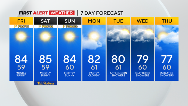
Looking ahead, besides today I have another four days on the 7 day with highs hitting 80° or higher. I have another day when we will be close.
Overall let's assume over the next week we will see the 80s another 3 times - that would put us at 103 days.
That would have us tied for the 10th most on record. The weather pattern appears to stay conducive to 80-degree weather at least through the end of the month so we could be making a run at top 3 record status.
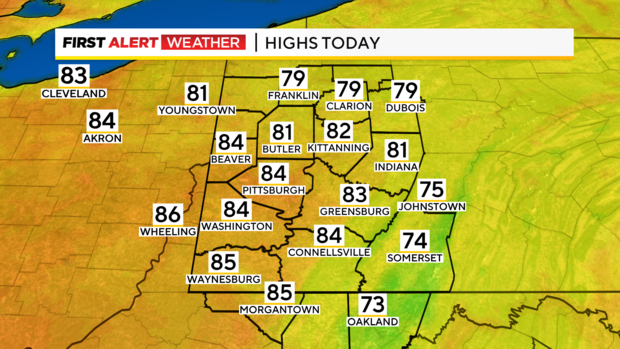
Getting back to the forecast, I have Pittsburgh seeing a high of 84° today. Once again, lunchtime temps should be near 80 degrees. Winds will be out of the east at around 10mph this afternoon.
Morning lows were near 60 again for most places. This weather pattern remains unchanged through the weekend. I do bring temperatures down to the low 80s on Monday and Tuesday even though rain won't be arriving until late Tuesday afternoon.
Our next rain chance will come from off the east coast. Something that is a little bit unusual for us.
This disturbance hasn't formed yet, but it is expected to develop out of the boundary that arises from post-Francine storms and rain.
This area could turn into a tropical storm before it moves inland in North Carolina and heads our way. Once it arrives the rain chance will stick around for the next couple of days.
Stay up to date with the KDKA Mobile App – which you can download here!