Maps show Helene's forecasted impact on Western Pennsylvania, bringing strong showers and wind
PITTSBURGH (KDKA) — Helene is expected to bring showers and some strong wind gusts to Western Pennsylvania after the storm slammed into the southeast, leaving over 20 dead and millions without power.
As of midday Friday, Helene has weakened to a tropical storm. It's merging with another area of low pressure over the Mississippi River Valley, which is allowing its low pressure and wind field to continue to expand, engulfing most states over the eastern third of the United States.
Helene made landfall as a Category 4 storm about 10 miles west of Perry, Florida, around 11 p.m. Thursday with maximum sustained winds of 140 mph, according to the hurricane center. The storm is now making its way north.
How strong will wind gusts be in Western Pennsylvania?
Western Pennsylvania is on the northern periphery of Helene's wind field and can expect gradually strengthening winds throughout the afternoon and evening.
For the lower terrain and river valleys west of the Laurel Highlands and the ridges, sustained winds of 15-20 mph are expected with occasional gusts to 30 mph at times. The higher terrain of the Laurel Highlands and the ridges will see much stronger winds, with gusts reaching upwards of 50 mph at times.
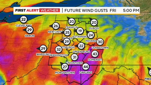
This could knock down tree limbs and loose items. A wind advisory is in effect until 10 p.m. Friday for portions of Westmoreland and Fayette counties in Pennsylvania, Monongalia and Preston counties in West Virginia and Garrett County in Maryland.
How much rain will Western Pennsylvania get?
Showers and periods of light rain are expected as well. Most of the rain will happen south of Pittsburgh as high pressure and drier air limit northward progression through the daytime hours. After 6 p.m., scattered showers should continue to trek north of Pittsburgh and into northwestern Pennsylvania during the evening and overnight hours.
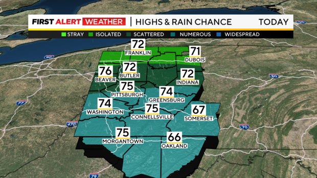
A dry slot still appears to move into most of the Pittsburgh region by Saturday, which should lead to lower chances of rain, warmer temperatures and even some breaks of sun in the afternoon. Isolated to scattered showers cannot be ruled out closer to I-80 and far southwestern Pennsylvania by late Saturday afternoon and evening.
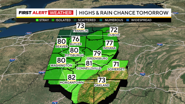
Remnants of Helene will eventually merge with an upper-level low to the west. That will move back over the Pittsburgh region Sunday through Monday night. This will bring increased clouds and rain showers starting as early as Saturday night and lasting through next Tuesday.
A stronger cold front could bring a few storms late Tuesday, but will ultimately lead to a push of drier and cooler air that will clear skies out by Wednesday afternoon next week.
Between Friday night and Saturday morning, rainfall amounts should range from a few hundredths of an inch to around 0.25 inches. An additional half-inch of rain is possible Sunday through Tuesday night.