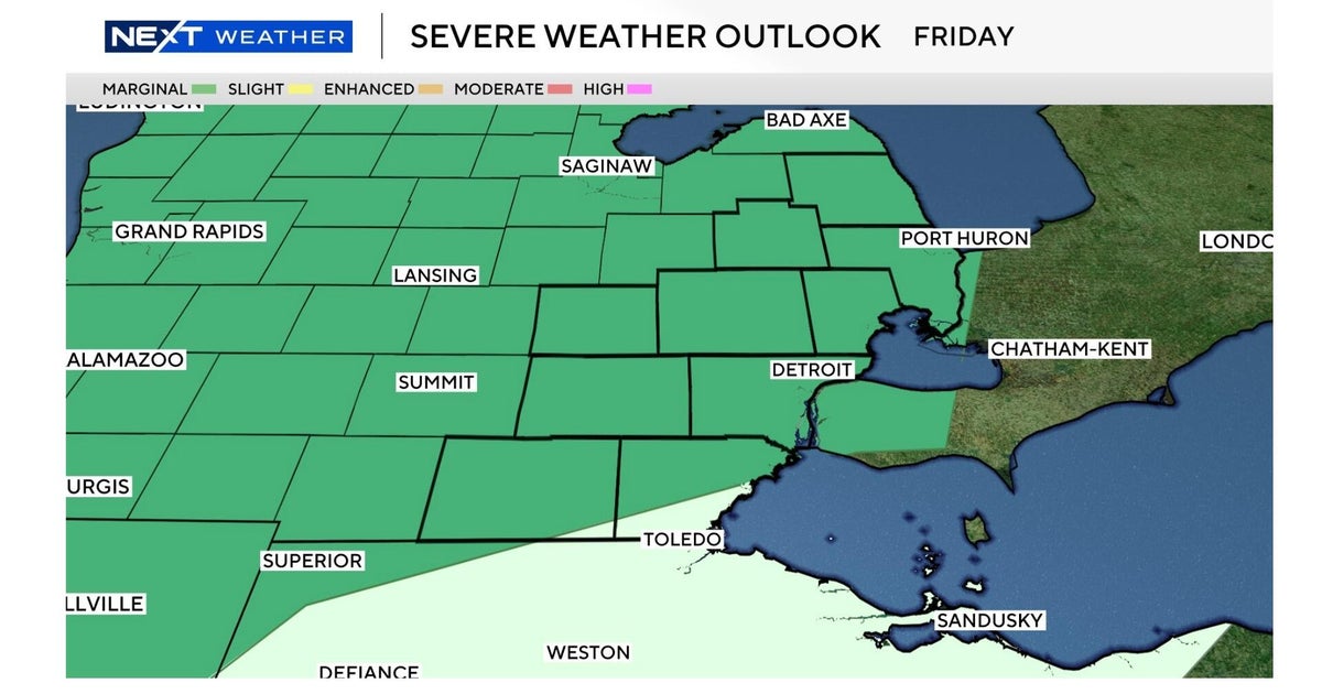
Hurricane Helene's death toll tops 160 as Southeast digs out from storm's devastation


As the number of storm-related deaths climbed past 160 across the Southeast, authorities were rushing to airdrop supplies, restore power and clear roads after massive rains from Hurricane Helene left people stranded and without shelter.
President Biden said he plans to visit areas in North Carolina devastated by flooding from Helene on Wednesday, but will try to limit his disruption of ongoing recovery efforts.
Mr. Biden said Monday he would travel to Raleigh for a briefing with the emergency operations center, then take an aerial tour of the damage in Asheville.
Mr. Biden told reporters at the White House there were reports that 600 people were unaccounted for following the storm, which knocked out communications to affected areas.
"God willing they're alive, but there's no way to contact them," Mr. Biden said.
Mr. Biden's homeland security adviser, Liz Sherwood-Randall, told reporters Monday over 3,500 federal response personnel were deployed to the area and the number of urban search and rescue personnel would be up to 1,250 in the coming days.
Former President Donald Trump visited Valdosta, Georgia, just north of the Florida-Georgia state line Monday afternoon. Wearing one of his red Make America Great Again campaign hats, Trump shook hands and spoke with supporters and a group from Samaritan's Purse, the charity run by evangelist Franklin Graham.
Trump's rival for the presidency in November, Vice President Kamala Harris, intends to visit the region when it won't disrupt response efforts.
Hurricane Helene death toll
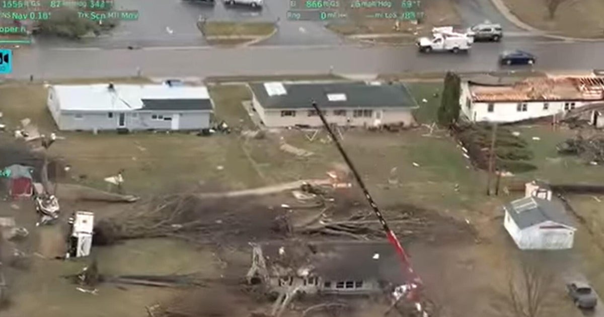
Helene has killed at least 161 people, CBS News confirmed. The storm appears to have inflicted its worst damage in the Carolinas, where officials said more than 113 people have been found dead.
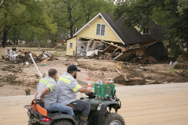
In the devastated city of Asheville, North Carolina, Megan Drye watched as her 7-year-old son Micah and her parents got swept away into the flood. They were stranded on a roof when it collapsed into the water. Megan Drye was rescued.
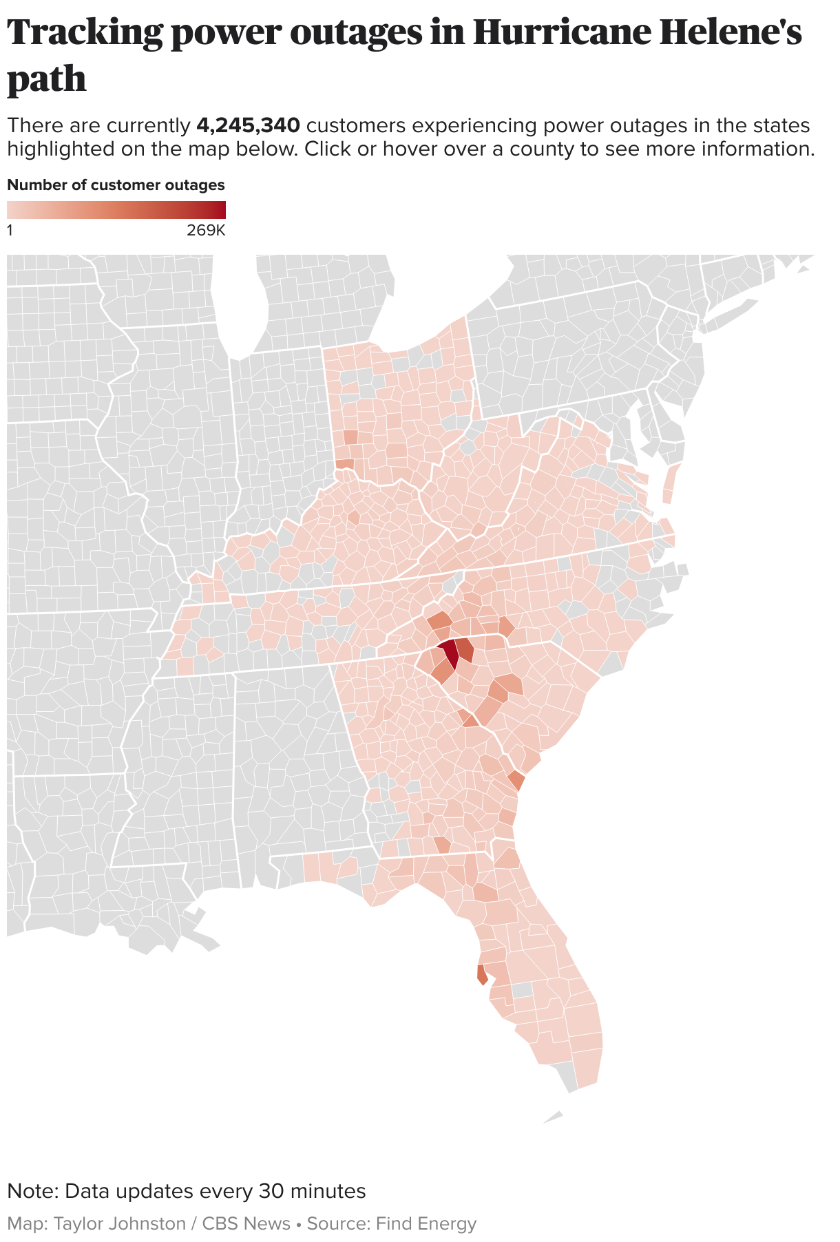
In Buncombe County, which includes Asheville, 57 deaths were reported. More than 95,000 Buncombe County homes and businesses had no power Monday afternoon, according to utility tracker Find Energy.
Buncombe County Manager Avril Pinder pledged in a call with reporters Sunday that she would have food and water to the city by Monday, The Associated Press reported. World Central Kitchen, the charity founded by chef José Andrés, said Monday that it had arrived in the city.
In North Carolina, at least 77 people were killed, officials confirmed to CBS News.
"This is an unprecedented tragedy that requires an unprecedented response," North Carolina Gov. Roy Cooper said at a news conference Sunday. He added that more deaths were expected as rescuers reach isolated areas.
In South Carolina, 36 people were confirmed dead from the storm as of Tuesday morning, according to the coroner's offices in 11 affected counties. Gov. Henry McMaster had announced most of those deaths Monday. They included two firefighters and two people who were killed when trees fell on residences, officials said earlier.
At least 25 people were killed in Georgia, according to a spokesperson for the Georgia Emergency Management Agency. A first responder was among the dead, Gov. Brian Kemp said Friday.
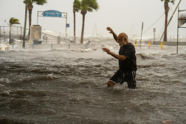
In Florida, 13 people were killed, officials confirmed to CBS News, including 10 people who died in Pinellas County. Statewide, crews have conducted thousands of rescue missions.
Six weather-related fatalities were confirmed in Tennessee.
In Virginia, Gov. Glenn Youngkin said in a Friday news conference that one person was killed. Another person was confirmed dead in Virginia on Monday.
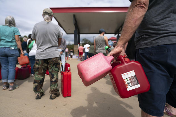
Helene knocked out power to several million customers. Over a million and a half still had no electricity Monday night, Find Energy reported. But Florida Gov. Ron DeSantis said Sunday night that 99% of that state's homes and businesses had their power restored.
Where did Hurricane Helene hit?
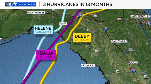
Helene crashed ashore in Florida's Big Bend area on Thursday night as a dangerous Category 4 hurricane. Helene was the third hurricane to hit that region in the last 13 months.
Florida before vs. after Hurricane Helene
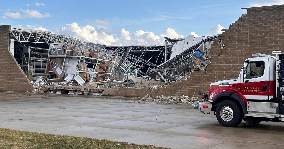
From there, it quickly moved through Georgia, where Kemp said Saturday it "looks like a bomb went off" after seeing splintered homes and debris-covered highways from the air.
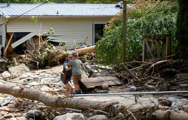
Helene then soaked the Carolinas and Tennessee with torrential rains, sending creeks and rivers over their banks and straining dams.
The National Weather Service on Saturday reported the highest rainfall totals from Helene for each state. As of Saturday morning, the rural northwest North Carolina area of Busick had received the highest overall rainfall, with a staggering 30.78 inches.
FEMA Administrator Deanne Criswell, who traveled to Florida on Saturday to survey the damage, said on "Face the Nation with Margaret Brennan" that the historic flooding in North Carolina has gone beyond what anyone could have planned for in the area.
"I don't know that anybody could be fully prepared for the amount of flooding and landslides that they are experiencing right now," she said.
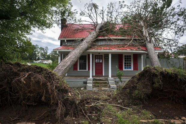
Asheville was particularly hard hit as rising floodwaters damaged roads, led to power outages and cut off cellphone service. On Sunday, Cooper asked residents to avoid traveling on roadways in western North Carolina.
"Many people are cut off because the roads are impassable," he said.
Mr. Biden has issued emergency declarations for Alabama, Florida, Georgia, North Carolina, South Carolina, Tennessee and Virginia, all of which free up federal resources that will go toward recovery and assistance efforts.
Moody's Analytics said it expects $15 billion to $26 billion in property damage. AccuWeather's preliminary estimate of the total damage and economic loss from Helene in the U.S. is between $95 billion and $110 billion.
In East Tennessee, the flooding was so bad that two dams were at risk of failing. The Cocke County city of Newport was evacuated as a result, but both dams ultimately held.
"Rescues have been made, attempts have been made, some people are stranded on the roofs of their homes and things like that," Cocke County Sheriff CJ Ball said.
The Gulf Coast community of Keaton Beach, Florida, was still recovering from Hurricane Idalia, which hit the area last year, and August's Hurricane Debby when Helene appeared to deliver the knockout punch. Taylor County officials estimated that 90% of homes in Keaton Beach are gone.
And further south in Cedar Key, officials said it is not safe for residents or rescue workers.
In the waters off Florida's Sanibel Island, a Coast Guard crew made a daring rescue, saving a man and his dog who were stranded on his 36-foot sailboat.
In the Big Bend fishing village of Steinhatchee, storm-weary residents prayed Helene would miss them, but the waterside docks and restaurants that once stood there are now gone.
The storm surge shoved buildings off their foundations. Linda Wicker lost the restaurant she had owned for 20 years. She seemed more shaken by what she saw across her village, homes torn apart by the wind and the deep water.
"If you let it play with your mind, you just can't go there," Wicker said. "You can't. It's horrible."
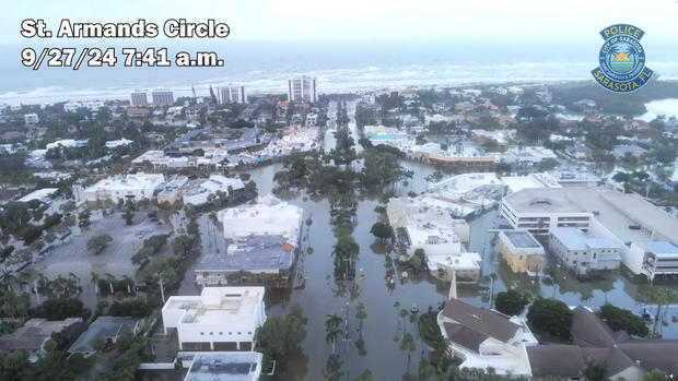
On historic Davis Islands in Tampa, streets were under water and boats had washed up on land. One home was gutted by flames. Marie Terry, who lives next door, would have been in the neighborhood unless her daughter had insisted she evacuate.
"I'm just in shock," Terry told CBS News. "It's just such a beautiful house, and to see it like this, it's like, what could have happened?"
In Atlanta, an apartment complex flooded, and neighbors had to rescue each other. Sam Oni, 83, was one of them.
"But I thought I would somehow escape it, but I did not…and I owe a lot to my neighbors," Oni told CBS News.
Serena Rodriguez was asleep in bed in her Atlanta home when she started floating, but it was not dream.
"It was like all around, the water, it was like an island," Rodriguez told CBS News. "…A nightmare mostly. Yeah, I was it was insane. Like, I couldn't believe it. I was in shock all the time. I never experienced anything like it."
CBS News senior weather and climate producer David Parkinson described Helene as a "gargantuan" storm. NASA shared video of the hurricane as seen from the International Space Station, showing the size of the storm as it churned through the Gulf of Mexico Thursday afternoon.
Exceptionally warm Gulf water fuels hurricanes
Record-warm water in the Gulf almost certainly acted like jet fuel in intensifying the storm. Brian McNoldy, senior research associate at the University of Miami Rosenstiel School of Marine, Atmospheric, and Earth Science, recently noted that ocean heat content in the Gulf of Mexico is the highest on record. Warm water is a necessary ingredient to strengthen tropical systems.
Sea surface temperatures in the path of Helene were as warm as 89 degrees Fahrenheit — 2 to 4 degrees above normal.
These record water temperatures have been made significantly more likely by human-caused climate change, according to Climate Central. The North Atlantic Ocean as a whole has seen record warm temperatures in 2024, storing 90% of the excess heat from climate change produced by greenhouse gas pollution.
Helene is the eighth named storm of the Atlantic hurricane season, which began June 1.