Hot weather is expected to stick around today throughout the Pittsburgh area
PITTSBURGH (KDKA) -- Temperatures are going to be hot again today in the Pittsburgh area.
Any Alert Days Ahead? Wednesday is a First Alert Weather Day. Saturday is a Potential First Alert Weather Day.
Aware: Yesterday's high of 91° was the 20th 90° day of the year. Strong chance we would have seen the most 90-degree days in a year in over 20 years (2001, 24) by the end of the week.
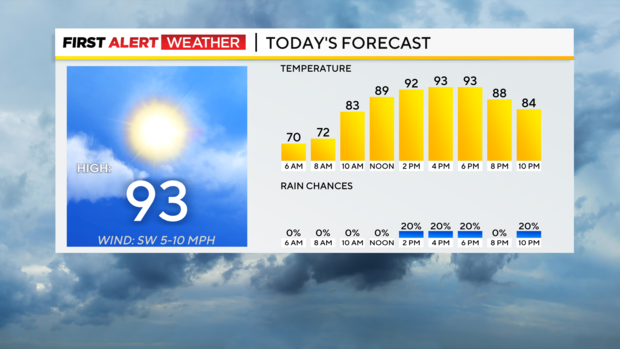
We hit 91 yesterday for the high and should be a couple of degrees warmer than that today. I have us hitting 93 for today's high and 94° for Wednesday's high. Winds will be out of the south today but light. Skies will be mostly cloudy and there will be just an isolated rain chance.
After a quiet stretch of weather stretching over a couple of weeks, things will begin to turn active starting Wednesday. We have now issued a First Alert Weather Day for Wednesday as we will see a shortwave trough sweep through during the afternoon hours.
Potential energy for any storms will be ample with high height falls and humidity levels at the surface extremely high with dew points near 70°. The short wave should be enough to trigger conditional storm development during the afternoon.
While everything will be possible (hail, wind, tornado), the biggest concern should be strong straight-line winds. NOAA's Storm Prediction Center also has large hail as an almost equal concern.
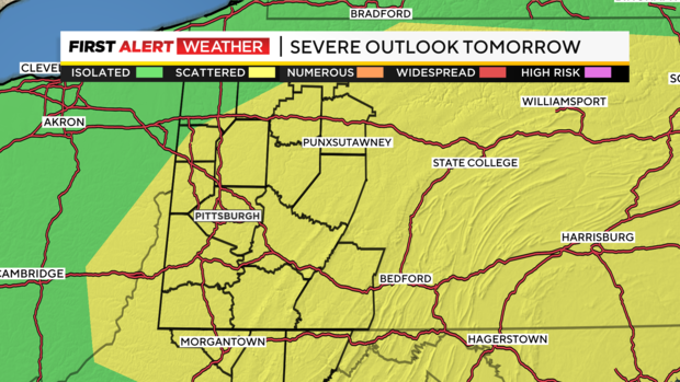
While severe weather is a possibility, there is a high level of uncertainty. Most model data this morning is struggling with adequately showing storm development due to a strong 'cap'. That's what we call a layer of stable air. Also, the timing of the shortwave is still a little uncertain. One of my preferred models shows the shortwave passing by in the morning hours during the morning commute. This could still lead to some morning storms, but the chance of severe weather from the storms would be a lot lower.
In addition to Wednesday's potential storm chance, we will also see an additional chance for storms and big rain totals on Saturday as the ridge of high pressure collapses and a cool front slides through. We will go from highs near 90 to highs in just the 70s within just a couple of days.
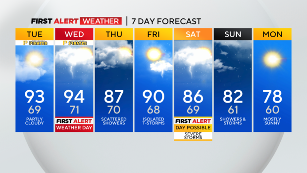
Saturday concerns will include severe weather along with flooding and flash flooding concerns. At this point, a lot can still change on Saturday so we will plop the 'potential' on there just to let you know we are watching it.
Rain showers and a couple of storms should stick around into Sunday too.
WEATHER LINKS:
Current Conditions | School Closings & Delays | Submit Your Weather Photos