Scorching temperatures prompt city's cooling centers to open, but work week looking wet as clouds, humidity increase
PITTSBURGH (KDKA) -- High pressure continues to bring dry, although, very warm weather this weekend across western Pennsylvania.
A slight push of south winds will transport even warmer air into our region on Sunday. This warmer air aloft combined with dry air will allow temperatures to quickly heat up this afternoon with highs soaring into the low 90s and perhaps a few upper 80s for higher elevations.
The air will be very dry by late July standards, so heat indices should be in very close range to actual air temperatures which should help prevent excessive heat-related health issues. If you do have plans to be outside, it is still best to be extra hydrated and wear light-colored, loose-fitting clothes.
Due to the heat, Pittsburgh is opening five of their Healthy Active Living Centers as cooling shelters. These centers are open Sunday, July 28, from 12 p.m. to 7 p.m.
Beechview Healthy Active Living Community Center
1555 Broadway Avenue
Pittsburgh, PA 15216
Brighton Heights Healthy Active Living Community Center
3515 McClure Avenue
Pittsburgh, PA 15212
Greenfield Healthy Active Living Community Center
745 Greenfield Avenue
Pittsburgh, PA 15217
Homewood Healthy Active Living Community Center
7321 Frankstown Road
Pittsburgh, PA 15208
South Side Healthy Active Living Community Center
12th & Bingham Streets
Pittsburgh, PA 15203
Monday will start to feature some transition from hot and dry conditions into progressively more humid and cloudier weather for the early part of the week. Clouds will increase through the mid-morning into early afternoon, especially for portions of West Virginia and far western Pennsylvania.
A few showers and isolated storms appear probable as well during the afternoon into the evening hours for locations west and south of Pittsburgh. These showers will likely have a hard time moving east initially, but as the flow aloft becomes stronger, that should aid in allowing scattered rain and storms to progress east into more of western Pennsylvania by Monday night and Tuesday.
Scattered storms will continue on Wednesday as well, but organized severe weather and widespread heavy rainfall appears unlikely with this first system. With the enhanced cloud cover and elevated moisture levels, temperatures Monday through Wednesday will only reach the low to mid 80s for highs with morning lows in the upper 60s to low 70s.
Thursday may feature lower coverage in rain and storm chances, but a stronger system is showing up in model guidance toward the end of the week. This may bring an uptick in rain and storm coverage by Thursday night and especially Friday.
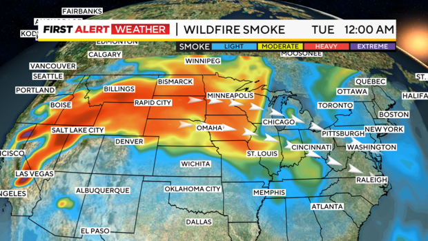
More wildfire smoke is also likely to make an appearance by mid to late week. The source region will be from fires in the West Coast and Pacific Northwest region.
