Cooler temperatures will stick around today in the Pittsburgh area, but a warmup is on the way
PITTSBURGH (KDKA) -- Temperatures in the Pittsburgh area will remain on the cool side today, but a big warmup is on the way.
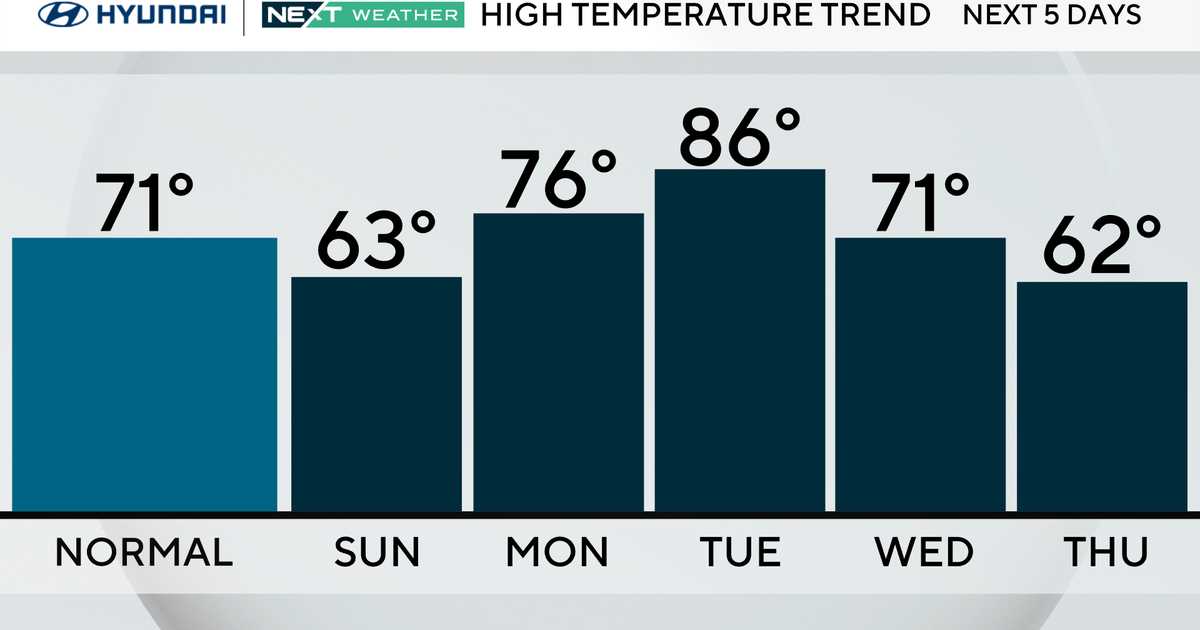
Any Alert Days Ahead? Sunday will be a potential First Alert Weather Day. Monday is a First Alert Weather Day due to highs hitting the 90's.
Aware: The hottest stretch of weather in years is possible, beginning on Sunday
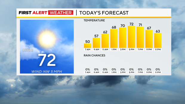
Temperatures will remain on the cool side of averages today with highs hitting the mid to low 70s. I have Pittsburgh's daily high temperature hitting 72°. The daily 'average' high for today is 78°. This morning will also be the coolest of the week as lows in Pittsburgh dipped to around 50°. Skies will remain mostly cloudy today with some peaks of sunshine here and there. Winds will continue to come in out of the northwest at 5-10mph.
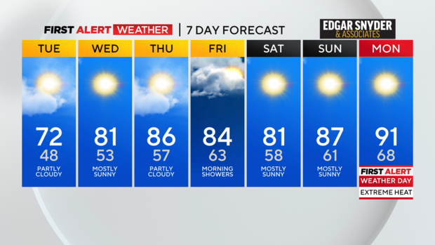
Looking ahead, we continue to warm up over the next couple of days with highs on Wednesday being close to 80 degrees. Thursday will see highs in the mid to upper 80s. There will be a rain chance, as we wrap up the day, as a cool front slides through. Model data shows the front sliding through mostly dry. Most of the rain from the front arrives on Friday morning. It doesn't look like it will be a lot of rain with data showing less than a fifth falling over both Thursday and Friday. Friday and Saturday will be cooler than Thursday as the cooler air rolls in. Highs on both days will still hit the 80s.
That brings us to next week's weather. I am already highlighting next Monday as a First Alert Weather Day due to the hot weather we are expecting. Sunday may be a First Alert Day as well. I have highs on Sunday hitting the upper 80s. I have Monday's high hitting the low 90s. The how air mass is expected to be around all next week. So we could potentially have seven straight days with highs hitting the 90s. A heat wave is a stretch of three days in a row with highs in the 90s with no point during the stretch (so the two nights in between) falling below 70°. There is a question right now if we will see some overnight relief from the heat with temperatures dropping to the 60s so we may not technically have a heat wave. It will be close either way it goes.
Looking at Pittsburgh's weather history, the last significant stretch of 90° weather or higher happened in July 2020 when we saw 8 straight days with highs hitting the 90s. In 2018 we saw four straight 90-degree days. That's it when it comes to 4 or more 90-degree days over the last 10 years. The longest stretch of 90-degree days occurred in 1988 when we saw 13 straight days at or above 90°. That's impressive.
When it comes to the heat now is the time to prepare. Make sure your a/c unit is in good working order. If you don't have a/c, have a plan to maybe go to the library or movie theater during the hottest time of the day. Spray parks are great and some are free for families with kids. For a cheap way to keep cool in a single room think about a bowl of ice in front of a fan. As the ice melts and eventually evaporates it will help to cool the air in front of the fan. The fan will spread the cooler air throughout the room. Make sure you check in on loved ones during the heat to make sure they're doing ok.
WEATHER LINKS:
Current Conditions | School Closings & Delays | Submit Your Weather Photos