The cold temperatures linger in Pittsburgh on Sunday before warmer weather on Monday
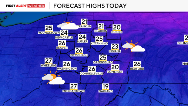
PITTSBURGH (KDKA) - Outside of a few flurries and mostly cloudy skies, Sunday begins on a cold note with temperatures in the mid-teens to near 20 degrees following the lake-effect snow bands from yesterday.
WEATHER LINKS:
Current Conditions | School Closings & Delays | Submit Your Weather Photos
While most locations did not see much snow yesterday, a narrow band of heavy lake-effect snow set along the I-76 corridor from northern Allegheny County into Beaver and Lawrence counties resulting in a narrow swath of 4-6 inches of accumulation. The snow bands set up in the area we had generally thought, but were much more intense than anticipated.
The main culprit behind this is high-resolution models underdoing the amount of low-level moisture and unstable air in the atmosphere which resulted in taller clouds with more moisture which led to more efficient snowfall production.
High pressure at the surface will settle through the day Sunday leading to clearing skies by late Sunday afternoon and evening. Under clear skies and light winds, Sunday morning and Monday morning will be the coldest with temperatures dropping into the teens across the area with even a few spots nearing single digits, especially close to I-80.
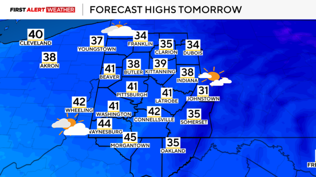
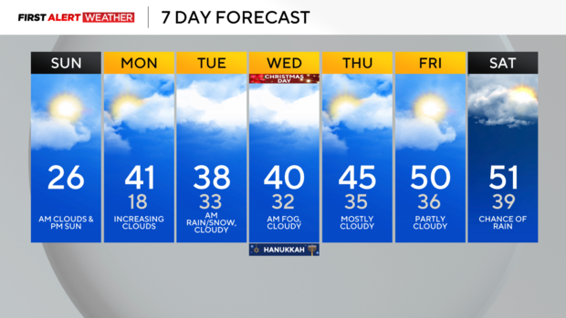
Winds will be light, so wind chills will not be dangerous or too far from the actual air temperature. High pressure will move to our east by Monday leading to southeast and southerly winds allowing the return of warm air in the low levels. Highs will reach the mid-30s to low-40s during the day. Skies will be partly cloudy in the morning, then become overcast by the afternoon and evening.
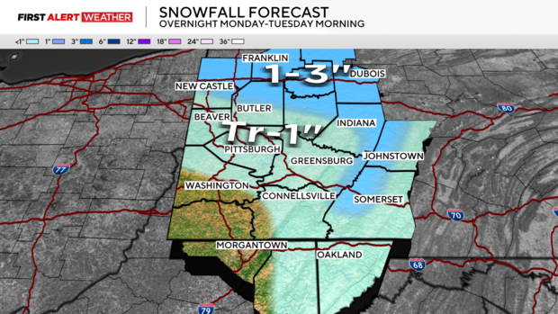
Another fast-moving wave of low pressure and its associated cold front will bring areas of rain and snow Monday night into Tuesday morning. There will be some minor accumulation, with the highest probability of that occurring, especially northeast of Pittsburgh. A range of 1-3" will be possible north of HWY 422 toward I-80 and in the Laurel Highlands, with significantly less far south and west.
Temperatures for the most part will be near and above freezing for most of this event and moderate into the mid to upper 30s by Tuesday, so expect melting.
Cloudy skies and near-average temperatures are expected most of Tuesday and Christmas Day. Light winds and moisture in the low levels will lead to areas of fog on Christmas morning. Southeasterly and southwest flow after Christmas should allow for above-average temperatures to persist into the final days of December before we close out 2024.
Stay up to date with the KDKA Mobile App – which you can download here!
