Severe storms move through Pittsburgh area as weekend concludes
PITTSBURGH (KDKA) -- Sunday morning begins with crisp and cool air across the region, but several changes are expected through the late morning into early afternoon.
Warmer and slightly moister air will move northeast from the Ohio Valley ahead of a strong cold front that will lead to a quick-hitting but potent round of thunderstorms later Sunday evening.
Highs will likely top out in the upper 70s to low 80s ahead of a more potent storm system and its associated cold front.
The air will become more moist through the day, although there are some discrepancies as to how much moisture moves in. Areas west and north of Pittsburgh will likely have the highest amounts of moisture with dew points reaching near 60 degrees and this is where the greatest amount of instability or storm fuel will be.
The Storm Prediction Center currently has most of the Pittsburgh area outlined in a level 2 "slight risk" and a level 1 "marginal risk" southeast of Pittsburgh. Strong wind gusts and hail (quarter to half dollar size) would be the primary risks with any cells that turn.
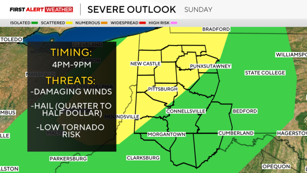
There is a very low tornado risk, especially closer toward I-80 across northwest Pennsylvania and northeast Ohio where slightly higher amounts of low level shear will be in place. However, limited amounts of moisture will likely keep cloud bases fairly high, which should hinder this threat.
Storms would likely develop by early to mid-afternoon around 3 to 4 p.m. across Ohio and then move into western Pennsylvania by 5 to 6 p.m. Showers and storms will impact the Pittsburgh metro area between 7 to 9 p.m., so if you're headed to the Steelers game, keep an eye on the radar and bring some rain gear as there will likely be some storms around game time.

The intensity of storms will diminish as storms move into and east of Pittsburgh as the air will be drier and less unstable. As quickly as the front moves in, any showers and ongoing storms will exit the region between 10 p.m. and after midnight, leading to breezy northwest winds and cooler air moving in from the northwest.
Monday will feature partly to mostly cloudy skies with highs in the low to mid-60s. Some lake-effect showers may affect our northernmost counties, mainly along and north of I-80.
A more persistent cool weather pattern will settle into the Pittsburgh region this week as a trough of low pressure settles just to the northeast. This will lead to several days of west to northwest winds with highs in the low-mid 60s and lows in the 40s, allowing for a true taste of fall.
As winds become calmer under high pressure by next Thursday and Friday, patchy frost is expected during the early morning hours of both days, especially for areas of the Laurel Highlands and the ridges.