Rain chances return across Pittsburgh area this week
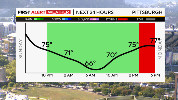
PITTSBURGH (KDKA) - Welcome to fall 2024! It officially arrived this morning at 8:44 am. We ended summer on another warm note, and today's high was still warmer than normal at 84 degrees (about 10 degrees above normal).
First Alert: None
Aware: Rain chances return tomorrow!
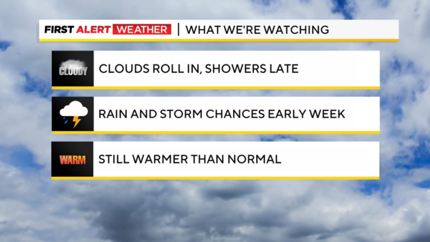
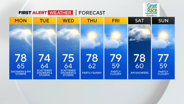
Get ready for some changes! We'll still stay warmer than normal most of this week with highs in the 70s, but no more widespread 80s, and clouds roll in tonight ahead of a system that will bring rain chances through early Thursday morning.
Broad southwesterly flow in the middle to upper atmosphere will send several disturbances our way beginning Sunday night through Wednesday, leading to periodic chances for showers and storms. There will also be above-normal amounts of moisture in the air to support rain, so confidence is high in decent precipitation chances to start the week. The initial trough or disturbance aloft in the atmosphere will likely bring a decaying complex of showers and storms our way on Monday morning. Some of our northern counties, especially along I-80, could see partial clearing Monday afternoon, while isolated showers and storms continue from Pittsburgh and points southeast toward the Laurel Highlands and northern West Virginia.
The best rain chance will come on Tuesday when a stronger disturbance with a more defined area of low pressure will move into central Ohio by mid-to-late afternoon. There will likely be several bands of showers and storms ahead of this that will move into western Pa. and northern W.Va. as early as midday to early afternoon. However, more widespread rain and storms are expected by afternoon and evening. Given the enhanced cloud cover, this should limit our severe weather potential Tuesday evening, but higher amounts of instability and some wind shear will be present across the border in Ohio, where some storms could turn severe.
More showers and a few storms are likely Wednesday while the pattern looks to move out Thursday and leave us dry to end the week after a few leftover morning showers. Rain totals could be ½ to one inch across the area, with some spots seeing higher totals if thunderstorms develop.
Monday's rain will be scattered and spotty, while Tuesday will be the soggiest of the upcoming days. Hopefully, we'll get some good rain totals to help alleviate drought conditions across the tri-state area.
WEATHER LINKS:
Current Conditions | School Closings & Delays | Submit Your Weather Photos