Map shows how tropical storm Beryl will impact the Pittsburgh area
PITTSBURGH (KDKA) -- Beryl made landfall in Texas on Monday, and a map shows the impact the storm will have on the Pittsburgh area as it continues inland.
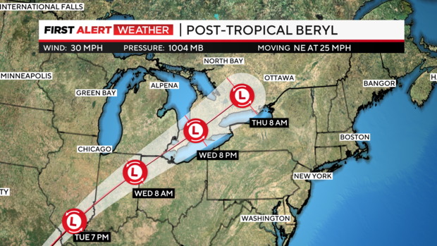
The remnants of Beryl, which came ashore as a Category 1 storm, are forecasted to reach western Pennsylvania on Wednesday. Strong storms with gusty wind are the main concern.
The track takes it over Toledo, Ohio, and more up towards the Toronto and Ottawa areas. By lunchtime Wednesday, the Pittsburgh area could see a pop-up storm or two with more activity forecasted into the afternoon. By 8 p.m., most models are pushing chances for decent rainfall east of the area.
Areas north of I-80 have the better chance for heavy downpours and strong to severe storms with a tornado possible. The Pittsburgh area needs rain, and while Beryl could bring an inch, it looks like it'll be about a half an inch to a quarter inch.
The track of Beryl can still change more northward, which could limit severe weather for the majority of the Pittsburgh region.
After Beryl hit the U.S. on Monday, slamming into the Gulf Coast just south of Houston, more than 2 million people lost power. At least seven deaths have been reported in Texas, according to CBS News.
Beryl caused at least 11 deaths when it hit the Caribbean islands last week, CBS News reported. It also slammed into Tulum, Mexico, as a Category 2 hurricane before weakening to a tropical storm.
The National Hurricane Center said Beryl was the earliest storm to develop into a Category 5 hurricane in the Atlantic and was only the second Category 5 storm recorded in July in nearly 20 years.
