Another winter storm brings freezing rain chance for Pittsburgh area

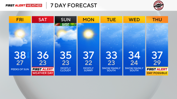
PITTSBURGH (KDKA) - Any Alert Days Ahead? Yes. Saturday is a FAWD. Next Thursday is a potential day. Tuesday and or Wednesday could also end up as FAWD days but holding off on tagging potential on them for now.
Aware: We've seen 21.6 inches of snow so far this season. It's solidly middle of the pack when it comes to comparing it to other seasons, and it is the most we have had through this point in three years.
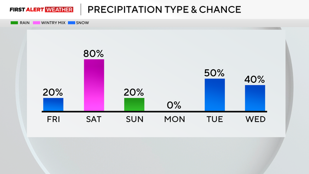
We have another round of freezing rain that will be possible on Saturday afternoon. Every chance of freezing rain is worrisome. This latest round will be problematic due to the timing, with freezing rain expected to occur during the afternoon. Unlike what we saw on Thursday, freezing rain in the afternoon will have a much larger impact. Temperatures are also expected to be colder on Saturday than they were Thursday morning. Expect poor conditions for the entire afternoon and evening as we await temperatures to rise above 32 degrees.
So why does freezing rain occur? Freezing rain occurs when there is a shallow layer of cold air at the surface with a warmer melt layer of air right above it. Oftentimes, warm fronts moving into and pushing out cool air is the perfect set-up for freezing rain. This is also the set-up for Saturday's freezing rain.
At this point, if you are between I-70 and I-80, expect freezing rain to start no later than 2 p.m. with freezing rain being possible through 9 p.m.
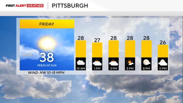
Looking at today's forecast, temperatures will slowly be dipping throughout the day. Morning temperatures will be in the low 30s with afternoon temperatures just in the 20s. Wind advisories are up for higher elevations through noon. Winds could go up to 50mph. Skies will be cloudy for the morning with partly cloudy afternoon skies expected.
WEATHER LINKS:
Current Conditions | School Closings & Delays | Submit Your Weather Photos