A hot afternoon with stormy conditions expected today for the Pittsburgh area
PITTSBURGH (KDKA) -- Afternoon conditions in the Pittsburgh area today are expected to be hot with stormy conditions.
Any Alert Days Ahead?- Wednesday is a First Alert Weather Day due to storm chances. Threats include straight line winds, large hail, tornadoes, downpours that could lead to brief street flooding and lightning.
Aware: Our average high and low are the highest they go for Pittsburgh. The average high for today is 82°. The average low is 62°.
For a lot of folks out there today will be completely dry. So if you live east of Pittsburgh or to the south, you can skip this paragraph and go straight to the next paragraph if you would like. For everyone else, the chance for rain is going to come from a rapidly weakening line of showers that will move into our area this afternoon. Model data has really struggled with this line of showers, and I mentioned yesterday that I was going to keep the rain chance in even though a lot of data wasn't picking up on it. Rain totals should be less than 0.05". We aren't talking a lot. The most notable thing these showers will do is bring some late afternoon relief from the heat with temperatures tumbling by around ten degrees behind the rain and staying near 80 degrees from then through sundown. I have the window for rain being from 3p - 5p.
Highs today should hit the upper 80s, with temperatures tumbling behind any rain you see this afternoon. Morning temperatures are in the comfy range too. Most places are well into the 50s for morning lows. I have noon temperatures near 80 degrees. Highs should be hit around 3p, a little earlier than normal for this time of the year due to anticipated rain arriving.
Strong storms will be possible on Wednesday afternoon. We were already included under a 'slight' risk of severe weather yesterday.
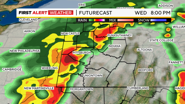
Slight is the term the Storm Prediction Center uses for a level 2 out of five severe weather risk. Five is the highest level. This level 2 risk is due to the risk of destructive straight-line wind, large hail, and tornadoes. Downpours and lightning are also possible. Right now it looks like any severe weather will occur from 5p to 10p on Wednesday. Outside that window, the risk of severe weather is low.
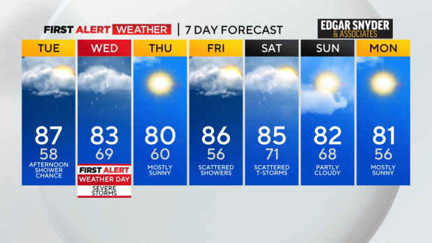
We have another cool front that will move through over the weekend. The timing right now of the front passing is all over the place. I have the front currently moving through late on Saturday; bringing with it a storm chance. We will have more on that as the day gets closer.
WEATHER LINKS:
Current Conditions | School Closings & Delays | Submit Your Weather Photos