Volcanoes seen from space
Awe-inspiring views of volcanic eruptions as seen from Space. While the destruction an erupting volcano can inflict is to be feared in any community living in site of one these fearsome aspects of planet earth's geography, nature's wrath also fascinates.
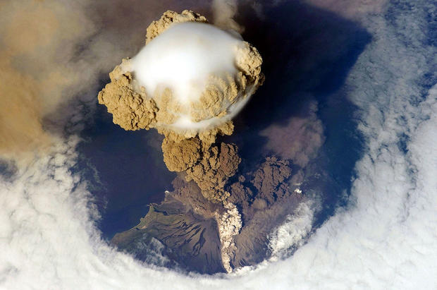
A fortuitous orbit of the International Space Station allowed astronauts this striking view of Sarychev volcano (Russia's Kuril Islands, northeast of Japan) in an early stage of eruption on June 12, 2009. Sarychev Peak is one of the most active volcanoes in the Kuril Island chain and is located on the northwestern end of Matua Island.
The main column is one of a series of plumes, which appear to be a combination of brown ash and white steam that rose above Matua Island (48.1 degrees north latitude and 153.2 degrees east longitude). The vigorously rising plume gives the steam a bubble-like appearance.
Manam Volcano
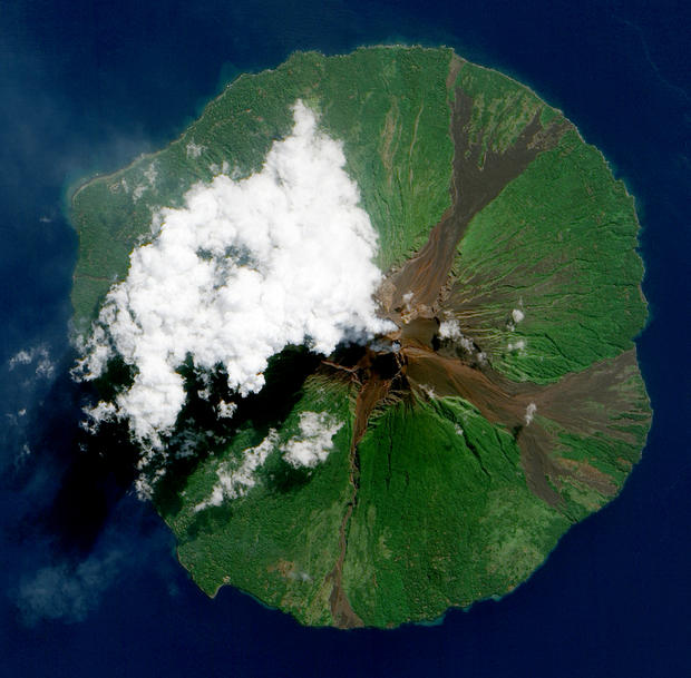
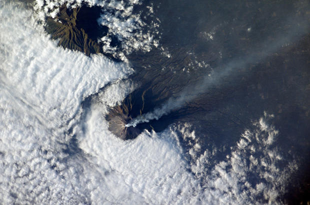
Papua New Guinea's Manam volcano released a thin, faint plume on June 16, 2010, as clouds clustered at the volcano's summit. Rivulets of brown rock interrupt the carpet of green vegetation on the volcano's slopes.
Located 13 kilometers (8 miles) off the coast of mainland Papua New Guinea, Manam, a stratovolcano, forms an island 10 kilometers (6 miles) wide. The volcano has two summit craters, with most eruptions have arising from the southern crater.
Stratovolcanoes are conical and comprised of many layers of volcanic ash, pumice, lava and tephra. The lava from these volcanoes generally doesn't spread too far.
Calbuco volcano
In April 22, 2015, Calbuco volcano in southern Chile began erupting for the first time since 1972. A tan ash cloud rose at least 15 kilometers (50,000 feet) above the volcano, menacing the nearby communities of Puerto Montt (Chile) and San Carlos de Bariloche (Argentina).
The eruption led to evacuations within a 20-kilometer (12 mile) radius around the volcano. About 1,500 to 2,000 people were evacuated.
Kliuchevskoi Volcano
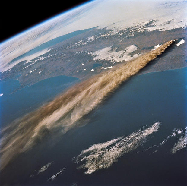
Astronauts photographed the plume from the Kamchatka peninsula's newly erupted volcano in late 1994 from 115 nautical miles above Earth.
Krakatau
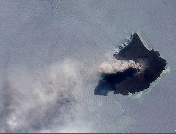
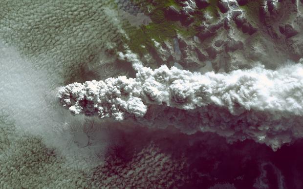
The thick plume of ash, steam and volcanic rose from Anak Krakatau on November 17, 2010. Krakatau was responsible for one of the largest and most destructive eruptions in Indonesia's history. For this reason, the volcano is one of 100 that NASA automatically monitors by satellite. Throughout the summer and fall of 2010, Krakatau erupted hundreds of times a day, but by November 17 activity at the volcano had started to slow.
Puyehue-Cordón Caulle Volcano
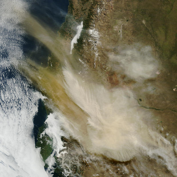
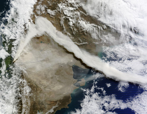
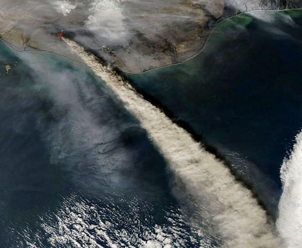
Puyehue-Cordón Caulle Volcano NASA image acquired June 6, 2011
After awakening on June 4, 2011, the eruption at the Puyehue-Cordón Caulle Volcanic Complex continued for at least two days. Located in Chile, just west of the border with Argentina Puyehue-Cordón Caulle emitted a plume of light-colored ash that stretched along the edge of the Andes. Hours earlier the prevailing winds had shifted, forming the prominent kink visible in the plume. This natural-color satellite image was made on the morning of June 6, 2011. At the time the Buenos Aires Volcanic Ash Advisory Center (VAAC) reported that the ash plume reached an altitude of 40,000 feet (12,000 meters).
Pavlof Volcano
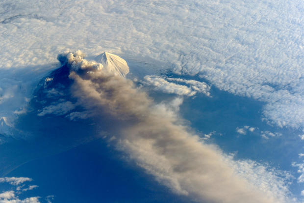
Astronauts aboard the International Space Station (ISS) photographed this striking view of Pavlof Volcano on May 18, 2013. The volcano jetted lava into the air and spewed an ash cloud 20,000 feet (6,000 meters) high.
Alaid Volcano
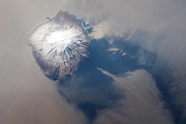
Reaching 2,339 meters above sea level, Alaid is the largest volcano in the Kuril Island chain off the coast of Japan. This photo of an eruption was taken by NASA's Expedition 31 crew on May 18, 2012.
Volcanoes in the Kurils and similar island arcs in the Pacific "ring of fire."
Merapi volcano
At 2,911 meters, the summit of Merapi Volcano and its vigorous steam plume rises above a bank of stratus clouds on August 24, 2003. The volcano is located less than 25 miles north of the city of Yogykarta in Indonesia's central Java.
Puyehue volcano
Southern Chile's Puyehue volcano came to life on June 4, 2011, after decades of dormancy. This photo taken June 11 shows how winds spread the ash column eastward over neighboring Argentina, leading to the evacuation of thousands of residents.
Ash from the volcano grounded flights in Chile, Bolivia, Argentina, Uruguay and Paraguay. Stratospheric winds carried the ash particles as far as Australia, causing disruption to air traffic over Australia and New Zealand.
Twin Kamchatka volcanoes
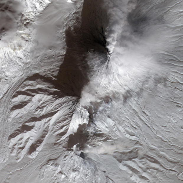
This view from The NASA Terra satellite shows the twin Kamchatka volcanoes erupting simultaneously in Kamchatka, February 18, 2010.
Eyjafjallajokull Volcano
Ash plume from Eyjafjallajokull Volcano, Iceland as seen by the Aqua satellite on May 8, 2010. The volcano is completely covered by an ice cap approximately 39 sq miles (100 square kms) in size.
Cleveland volcano
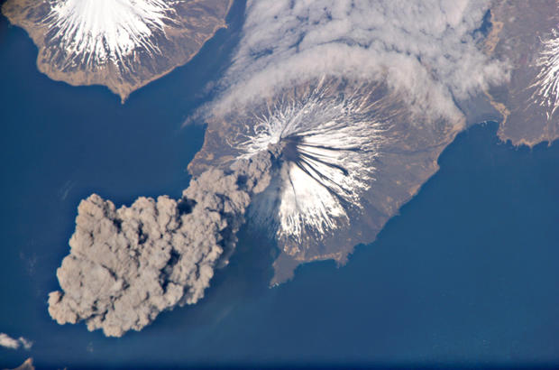
Cleveland volcano's eruption in the Aleutian Islands of Alaska was captured by an Expedition 13 crew member on the International Space Station, in May 23, 2006. The eruption was short-lived; the plume had completely detached from the volcano summit two hours later.
Nyamuragira and Nyiragongo
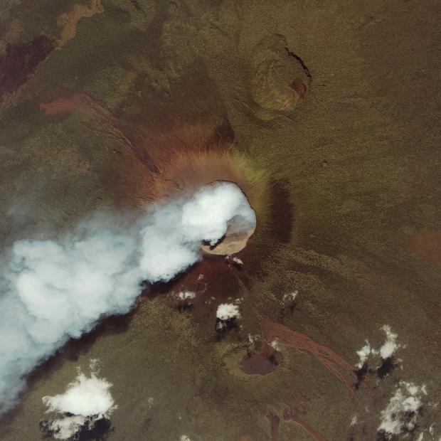
Two East African volcanoes, Nyamuragira and Nyiragongo, account for 40 percent of all recorded eruptions in Africa. The two volcanoes sit along the edge of the Western Rift, part of a giant crack in the Earth's crust that runs for thousands of miles from the Middle East southward to central Africa.
In addition to their shared tendency to produce unusually fast-moving lava flows, the two volcanoes have an even rarer trait in common. The crater of each has periodically contained a lava lake, a huge volume of molten lava pooling in a high-walled summit crater. The lava lakes can drain during eruptions, either spilling over the rim of the crater or bursting from a fissure or vent on the flank.
Okmok Caldera
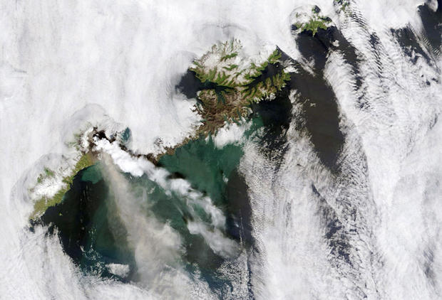
The Terra satellite captured this image of the Okmok Caldera erupting on Umnak Island in Alaska, July 13, 2008. Viewed through a break in the clouds, both a steam plume, right, and an ash plume emanate from the volcano. The steam is snowy white like the nearby clouds. The ash is slightly darker. The blue-green color of the nearby ocean water may be the result of volcanic ashfall.
Sangeang Api volcano
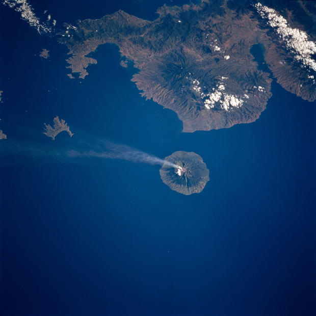
This photo of Sangeang Api volcano in the lesser Sunda Islands of Indonesia was taken from the Space Shuttle Columbia on July 9, 1997. The eruptions from this volcano are often effusive with lava flows. The last eruption was in July of 2015 and continues to be active.
Gaua Island
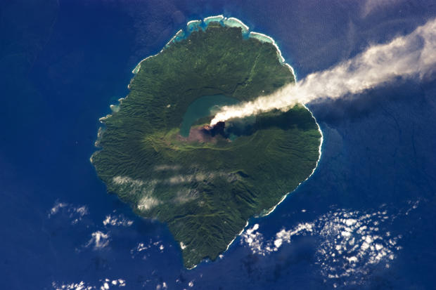
Just 20 kilometers (12 miles) in diameter, Gaua Island is actually the exposed upper cone and summit of a stratovolcano that is 3,000 meters (10,000 feet) high and 40 kilometers (25 miles) in diameter.
Most of the volcano is submerged beneath the Pacific Ocean. Also known as Santa Maria Island, Gaua is part of the Vanuatu Archipelago, a group of volcanic islands in the South Pacific Ocean.
