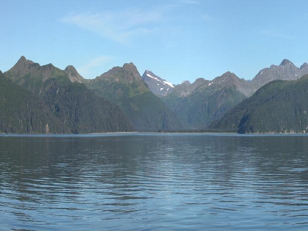
Vanishing glaciers of Alaska
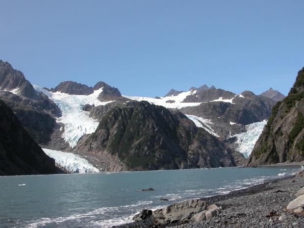
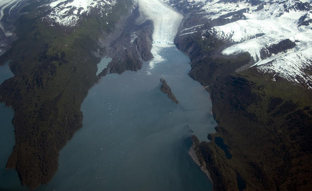
Photographs taken at the same locations decades apart reveal just how dramatically Alaska's glaciers are melting and retreating. Scientists from the University of Alaska and the U.S. Geological Survey estimate that Alaska is losing ice at the rate of 75 billion metric tons a year. They calculate that Alaska's glaciers and frozen rivers are melting fast enough to cover the whole state with 30 centimeters of water (nearly a foot) every seven years.
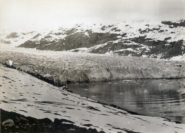
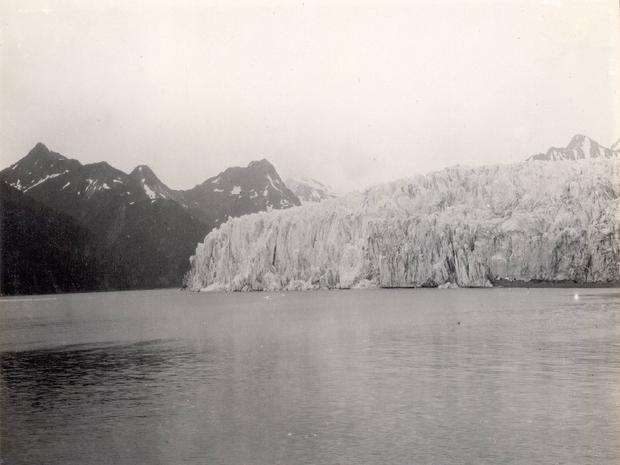
Muir Glacier, 1892
This photo and the one that follows were taken from the same location on the west shoreline of Muir Inlet, Glacier Bay National Park and Preserve, Alaska, and show the changes that have occurred to Muir Glacier during the 113 years between September 1892 and August 2005. The 1892 photograph shows the more than 100 meter (328 feet) high, more than 4 kilometers (2.5 miles) wide tidewater terminus of the glacier with a face capped by angular séracs. Some icebergs, evidence of recent calving, can be seen floating in Muir Inlet
Muir Glacier, 2005
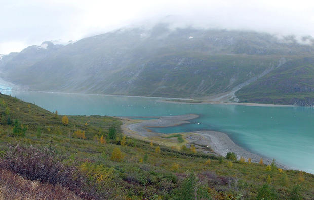
In the 2005 photograph, Muir Glacier is no longer visible, as it has retreated more than 50 kilometers (31 miles). During the 113 years between photographs, Muir Glacier ceased to have a tidewater terminus. Note the lack of floating ice and the abundant vegetation on many slopes throughout the photograph.
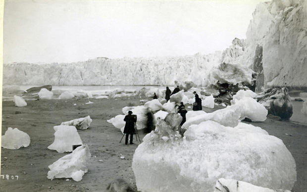
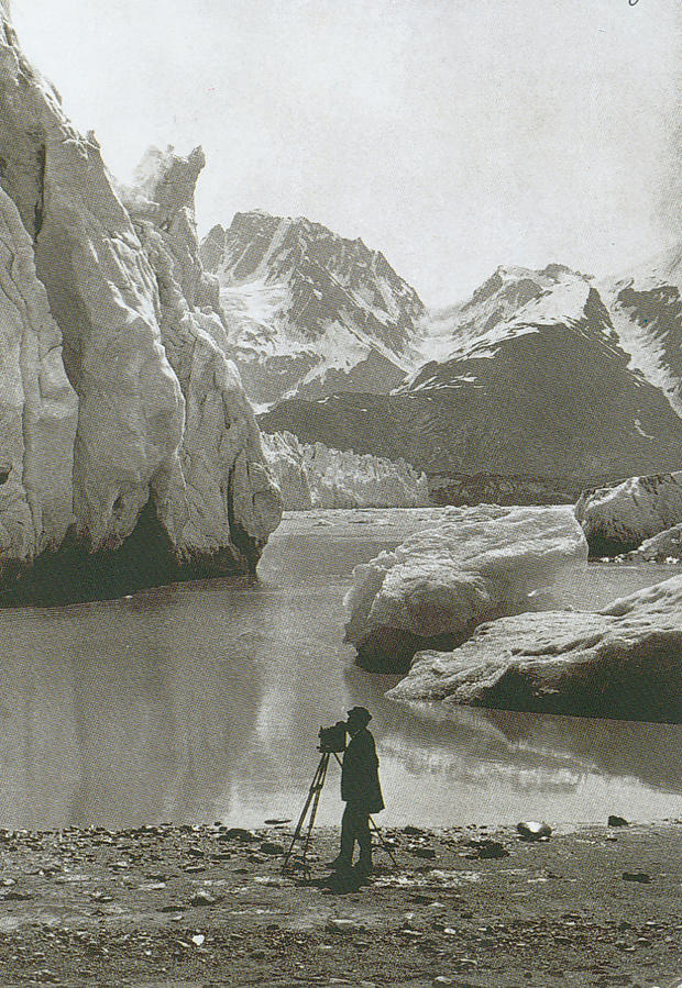
Muir Glacier, 1880s-1890s
The east shoreline of Muir Inlet, Glacier Bay National Park and Preserve, Alaska, pictured during the 1880s or 1890s.
The early photograph shows the more than 100 meters (328 feet) high tidewater terminus of the glacier with a face capped by angular séracs. Numerous icebergs, some more than 2 meters (6.6 feet) in diameter are grounded on the tidal flat in the fore- and middle-ground of the photograph. The tidal flat is probably ice cored, underlain by glacier ice. The tides in this area are greater than 3 m (9.9 feet).
A photographer and seven tourists are exploring the icebergs.
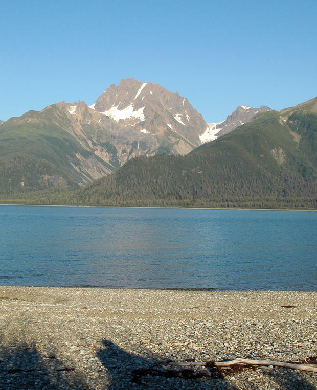
Muir Glacier 2005
The same shoreline in 2005.
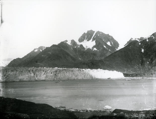
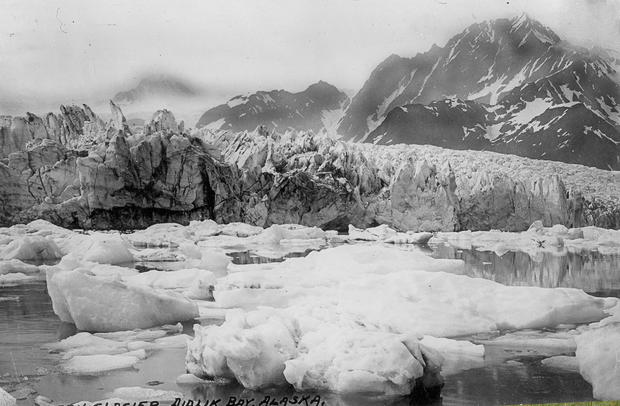
Muir Glacier and Inlet, late 19th century
Muir Inlet, pictured in a late 19th century photograph, actually a postcard.
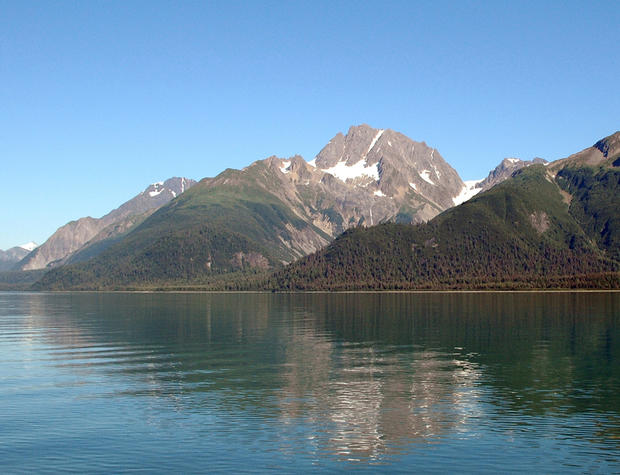
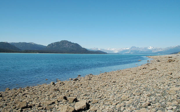
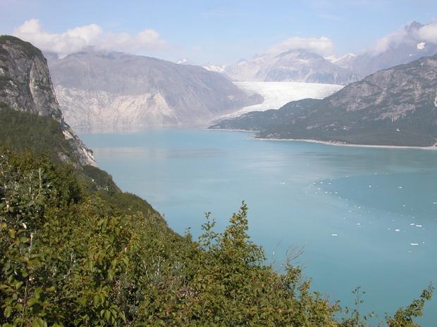
Muir Glacier and Inlet, 2005
In the roughly 105-110 years between photographs, Muir Glacier has retreated more than 50 kilometers (31 miles) and is completely out of the field of view.
The angular rocks in the foreground are part of a cobble lag deposit winnowed from sediment previously deposited by Muir Glacier and by melting grounded icebergs. Note the abundant vegetation on the near-ground slopes on the east side of Muir Inlet and in the lower part of Adams Inlet.
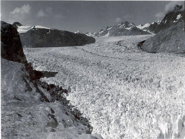
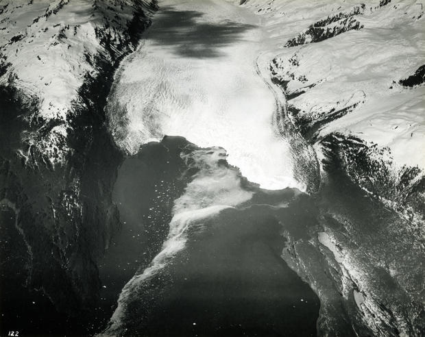
White Thunder Ridge, Muir Inlet, 1941
This 1941 photograph shows the lower reaches of Muir Glacier, then a large, tidewater calving valley glacier, and its tributary, Riggs Glacier. Muir and Riggs Glaciers filled Muir Inlet.
The ice thickness in the center of the photographs is more than 0.7 kilometers (0.43 miles). For nearly two centuries prior to 1941, Muir Glacier had been retreating. In places, more than a 1.0 kilometer (0.62 mile) thickness of ice had been lost. Note the absence of any identifiable vegetation and the numerous bare bedrock faces present on both sides of the glacier (W. O. Field, # 41-64, courtesy of the National Snow and Ice Data Center and Glacier Bay National Park and Preserve Archive).
White Thunder Ridge, Muir Inlet, 2004
Six decades later, Muir Glacier has retreated out of the field of view and is now located more than 7 kilometers (4.4 miles) to the northwest. Riggs Glacier has retreated as much as 0.6 kilometers (0.37 miles) and thinned by more than 0.25 kilometers (0.16 miles). Note the dense vegetation that has developed on the till cover of White Thunder Ridge.
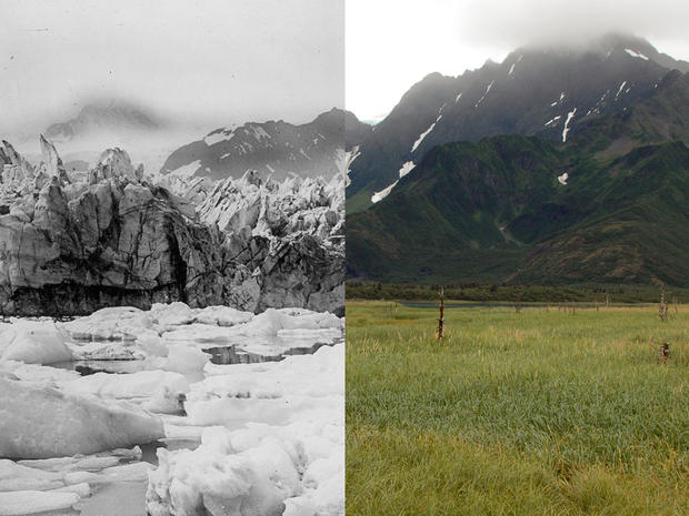
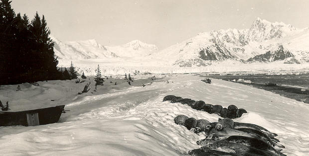
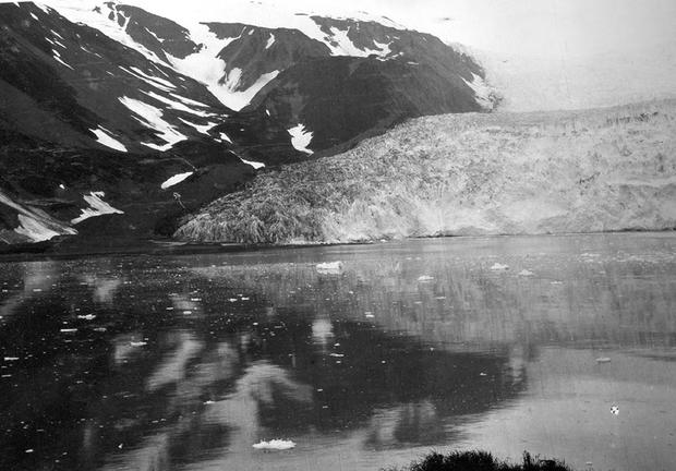
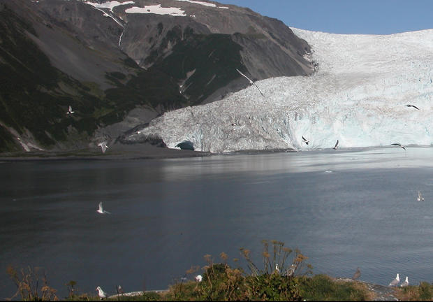
Northwestern Glacier, 1920-1940
This northeast-looking photograph and the one that follows were both taken from the same location on the west shoreline of Harris Bay, Kenai Fjords National Park, Kenai Mountains, Alaska.
The first photograph is an undated winter to early spring view, probably taken between the mid-1920s and the 1940s. The shallow water adjacent to the shoreline in the foreground appears to be covered by a small thickness of sea ice, containing a number of pieces of brash ice. Northwestern Glacier spans most of the width of the photograph. When photographed, the glacier was retreating and had a sérac-capped terminus that ranged from 20-50 meters (65.6-164 feet) high. Note the large trees. This location was being used for subsistence hunting by local Native Alaskans.
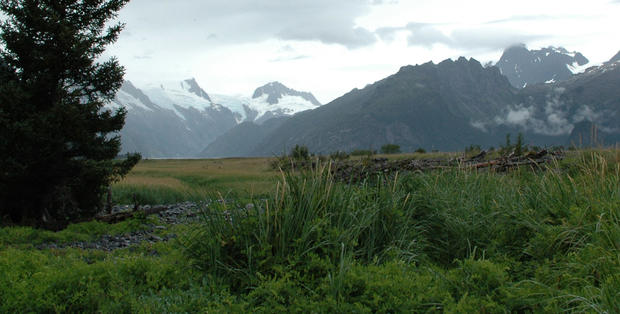
Northwestern Glacier, 2005
This photograph of the same location dates from August 12, 2005. In the roughly 60-80 years between photographs, Northwestern Glacier has retreated out of the field of view. Sedimentation and uplift have expanded the shore area and produced a marshy wetland covered by a diverse array of vegetation.
Reid Glacier, 1899
A pair of northwest looking photographs, both taken from the same location on the southwest side of Reid Inlet, Glacier Bay National Park and Preserve, Alaska, showing the changes that have occurred to Reid Glacier during a period of more than a century, between June 10, 1899 and September 6, 2003.
The 1899 photograph is taken towards the northwest and shows the approximately 60 meter (197 foot) high tidewater terminus of the then retreating Reid Glacier. The hillside in the foreground is covered by a few centimeters (inches) of snow. No trees are present on the hillside or on any other surface in the field of view. A few icebergs of various sizes are floating in the water in front of the glacier.
Reid Glacier, 2003
In the 104 years between photographs, Reid Glacier has retreated about 3 kilometers (1.9 miles) and is just visible at the head of the fiord on the left side of the field of view. The hillside in the foreground is covered with dense vegetation, including both conifers and deciduous trees. Vegetation, predominantly alder, covers much of the lower slopes on the opposite side of the inlet.
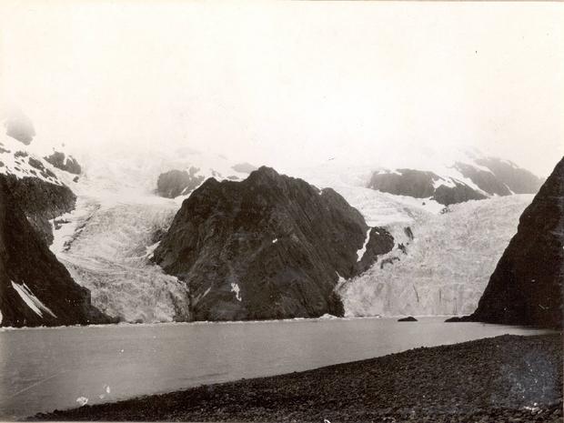
Pedersen Glacier, 1920-1940
A view looking north toward Pedersen Glacier, Kenai Mountains, Aialik Bay, Alaska, taken from the west shoreline of Aialik Bay. The first photograph is an undated summer view, probably dating from between the mid-1920s and the early 1940s.
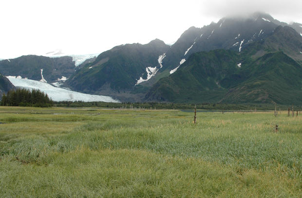
Pedersen Glacier, 2005
This photograph of the same location dates from August 10, 2005. In the roughly 60-80 years between photographs, most of the lake/lagoon has filled with sediment and now supports several varieties of grasses, shrubs, and aquatic plants.
Several dozen dead trees are remnants of a mid-20th century forest that was drowned by more than 3 meters (9.8 feet) of down warping of the coast during the 1964 Alaskan Earthquake. Pedersen Glacier's terminus has retreated more than 2 kilometers (1.24 miles). The tributary located high above Pedersen Glacier separated from it sometime during the third quarter of the 20th century. No icebergs are visible. Isolated patches of snow are present at a few higher elevation locations. Note the stands of trees that have developed between the sediment filled wetland and the glacier.
McCarty Glacier, 1909
A pair of northwest-looking photographs taken from about 8 kilometers (5 miles) north of the mouth of McCarty Fjord, Kenai Fjords National Park, Alaska. The pair documents significant changes that have occurred during the 95 years between July 30, 1909 and August 11, 2004.
The 1909 photograph by USGS Geologist U.S. Grant shows the west side of the terminus of the then retreating McCarty Glacier, a tidewater glacier. Little, if any vegetation is present in the photograph.
McCarty Glacier, 2004
This 2004 photograph documents the retreat of McCarty Glacier from the field of view, a retreat of more than 15 kilometers (9.8 miles). Dense, diverse vegetation, featuring spruce, has become established on the hill slopes.
Aialik Glacier, 1909
A pair of northwest looking photographs of Aialik Glacier, Kenai Fjords National Park, Kenai Mountains, Aialik Bay, Alaska, both taken from the same location on the northwest shoreline of Squab Island. The first photograph by U.S. Grant, is a July 20, 1909 view of the then slowly retreating western part of the terminus.
Aialik Glacier, 2005
The second photograph dates from August 12, 2005. In the 96 years between photographs, the terminus of Aialik Glacier remains close to its 1909 position, retreating a maximum of 300 meters (984 feet) and thinning 20-50 meters (65.6-164 ft). Note that vegetation has developed on nearly every exposed land surface.
Holgate Glacier, 1909
A pair of northwest-looking photographs taken from near the head of Holgate Arm, Aialik Bay, Kenai Fjords National Park, Alaska. The pair documents significant changes that occurred during the 95 years between July 24, 1909 and August 13, 2004.
The 1909 photograph by USGS Geologist U.S. Grant shows Holgate Glacier, a tidewater glacier at the head of the fiord with Little Holgate Glacier, one of its former tributaries, located to its left. Little Holgate Glacier terminates at the shoreline. No vegetation is present at the head of the fiord.
Holgate Glacier, 2004
The 2004 photograph documents the continuing retreat of both glaciers. Little Holgate Glacier has separated into several smaller ice masses and Holgate's terminus, while still tidewater, has retreat from the field of view. Alder has become established on the hill slopes.
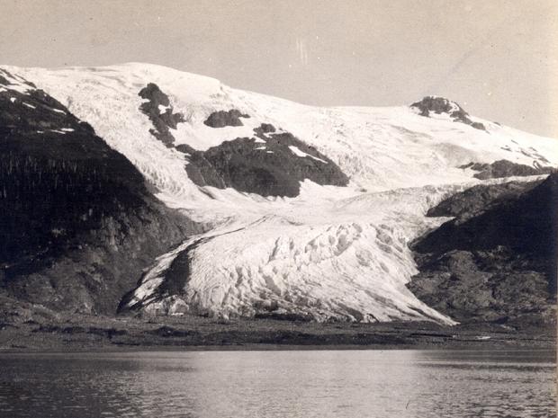
Toboggan Glacier, 1905
These north-looking photographs, all taken from about the same offshore location, about 0.5 kilometers (0.3 miles) north of Toboggan Glacier, Harriman Fiord, Prince William Sound, Chugach National Forest, Alaska. The photographs document significant changes that have occurred during the 103 years between August 20, 1905 and August 22, 2008.
The 1905 photograph shows that Toboggan Glacier was thinning and retreating and was surrounded by a large bedrock barren zone. This suggests that retreat and thinning began in the mid- to late-19th century. Minimal vegetation existed on the fiord-facing hill slopes.
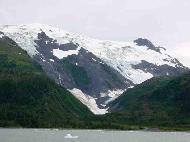
Toboggan Glacier, 2000
The 2000 photograph documents that after 95 years, the glacier is still thinning and retreating. Its terminus, a thin tongue of ice, can be seen surrounded by a mass of debris.
The glacier has thinned as much as 150 meters (492 feet) and retreated more than 0.5 kilometers (0.3 miles). A large accumulation of snow sits on the valley floor adjacent to where the northern-most hanging glacier tributary previously joined Toboggan Glacier. The tributary no longer makes contact, having retreated more than 0.6 kilometers (0.37 miles) up the valley wall. The former zone of barren bedrock is now covered by vegetation.
Yale Glacier, 1937
This pair of oblique aerial photographs of Yale Glacier, Chugach Mountains, Chugach National Forest, Alaska, documents changes that occurred during the 69 years between June 1937 and July 28, 2006. Both photographs are taken towards the north and show the retreating, calving, tidewater terminus of Yale Glacier, located at the head of Yale Arm, College Fiord, Prince William Sound, Alaska.
In 1937, Yale Glacier's terminus was located at about the same position that it occupied when it was visited by the Harriman Alaska Expedition in 1899. A stream of icebergs issues from several embayments cut into the approximately 45 meter (148 feet) high face on the east side of the terminus. Except for the moraine-covered ice on both margins of the glacier, snow still covers most of the lower reaches of the glacier.
Yale Glacier, 2006
During the intervening 69 years between photographs, Yale Glacier has retreated as much as 6 kilometers (3.7 miles), with most of the retreat occurring post-1957.
The width of the tidewater part of the terminus of the glacier is much less than half of what it was in 1937. Yale Glacier has thinned substantially, in places by more than 250 meters (820 feet). All of the eastern tributaries have retreated and lost contact with Yale Glacier. An island and a large area of glacially sculpted bedrock have emerged from beneath the retreating glacier. Retreat of the land-based western portion of the terminus has kept pace with the retreat of the eastern tidewater portion of the glacier. A well-developed trimline is visible on the west side of the glacier.
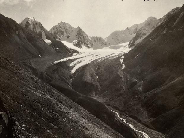
Unnamed glacier, 1919
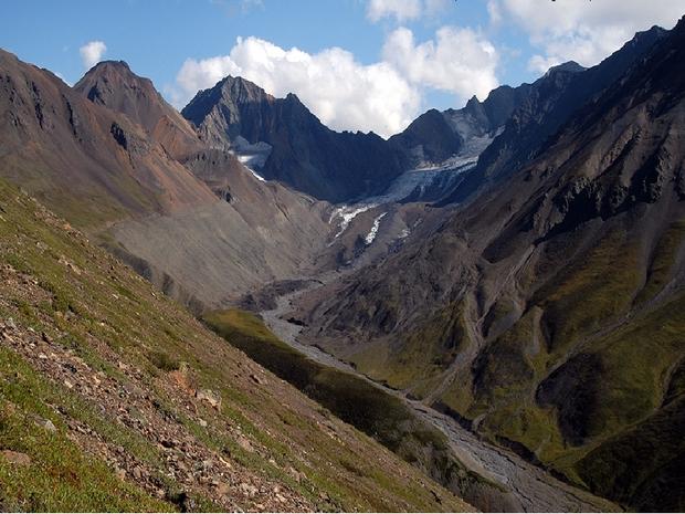
A pair of north-looking photographs, both taken from the same location near the retreating unnamed valley glacier that forms the East Fork of the Teklanika River, Denali National Park and Preserve, Alaska. The pair documents changes that have occurred during the 85 years between June 1919 and August 2004.
The 1919 photograph by USGS Geologist Stephen Capps shows the then retreating, debris-covered terminus of East Fork Teklanika Glacier, with an elevated lateral moraine on its west (left) side. Small tundra plants are the only identifiable vegetation.
Unnamed glacier, 2004
The 2004 photograph documents the continued thinning and retreat of East Fork Teklanika Glacier. The glacier has retreated more than 0.3 kilometers (0.19 miles) since 1919, retreating at an average rate of about 4.0 meters (13 feet) per year.
