Hurricane Milton, a powerful Category 4 storm, prompts new warnings for Florida amid mass evacuations
Update: Read the latest on Hurricane Milton here as it approaches the Florida coast. Our earlier coverage is below.
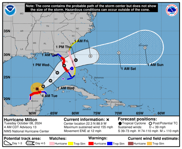
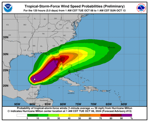
Hurricane Milton, a powerful Category 4 storm with maximum sustained winds of 145 miles per hour, kept tracking eastward early Tuesday as it churned just off the north coast of Mexico's Yucatan Peninsula. Milton's path is expected to bring life-threatening conditions to parts of Florida when it makes landfall early Thursday, forecasters said.
At 8 a.m. Eastern on Tuesday, the hurricane was moving east-northeast at 12 miles per hour over the warm Gulf waters. Earlier Monday Milton's winds surged past 175 mph and beyond, exceeding the threshold for Category 5 storm by a significant margin. The storm's wind speeds had more than doubled in 48 hours.
Forecasters with the hurricane center predict the storm will strike Florida's western Gulf Coast as a major hurricane in the middle of the week. Milton is slated to arrive on land early Thursday morning, said CBS News meteorologist Nikki Nolan, pushing the timeline slightly from a previous landfall prediction that suggested it would happen Wednesday night. It comes after Florida's Gulf Coast was just hit by Hurricane Helene.
Milton is expected to continue weakening somewhat before making landfall, but projections have varied and the hurricane center stressed that "while fluctuations in intensity are expected, Milton is forecast to remain an extremely dangerous hurricane through landfall in Florida." Nolan and CBS News weather senior producer David Parkinson on Monday said the storm would likely be a still-powerful Category 3 — meaning wind speeds somewhere between 111 and 129 mph — when it strikes land.
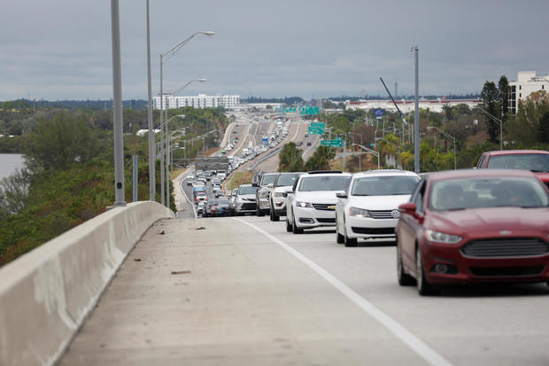
Mass evacuations are underway as Florida braces for another hurricane. Mandatory evacuations orders were issued Monday for parts of Tampa and scheduled to take effect at 2:30 p.m. Officials in Hillsborough County, which includes Tampa Bay, said they would open nine shelters throughout the county for residents in mandatory evacuation zones as well as people whose homes are vulnerable to storm surge, flooding and wind damage.
Tampa Mayor Jane Castor urged people in those areas to follow the evacuation orders in stark comments to CNN.
"We are talking about the possibility now of a direct hit," Castor said. "Helene was a wakeup call. This is literally catastrophic. And I can say, without any dramatization whatsoever, if you choose to stay in one of those evacuation areas, you're going to die."
The mayor noted that traffic jams on highways around Tampa since the orders took effect indicate Tampa area residents are taking the warnings seriously.
Hurricane warning area
Hurricane warnings expanded early Tuesday to Florida's east coast, where one was issued from the Indian River/St. Lucie County Line northward to Ponte Vedra Beach. A hurricane warning was already in place for the west coast of Florida from Bonita Beach northward to the mouth of the Suwannee River, including Tampa Bay.
The most likely track suggests Milton could make landfall in or near the Tampa Bay area and remain a hurricane as it moves across central Florida into the Atlantic Ocean.
The National Weather Service in Tampa Bay said in a briefing Monday morning that the hurricane "will be a historic storm for the west coast of Florida." If Milton continues along the current track, it could be the worst storm to impact the Tampa area in more than a century, according to the weather service.
That path would largely spare Georgia, North and South Carolina and other southeastern states ravaged by Helene, which caused catastrophic damage from Florida into the Appalachian Mountains, killing more than 230 people.
Storm surge a major concern
While Milton is expected to be a smaller storm than Helene, with a smaller wind field, it appears to be heading for a much more densely populated area, and storm surge could cause major problems.
A storm surge warning has been issued for the west coast of Florida from Flamingo northward to the Suwannee River, including Charlotte Harbor and Tampa Bay.
A stretch of the Florida Gulf Coast, including Tampa Bay, could see storm surge of 10 to 15 feet above normal water levels.
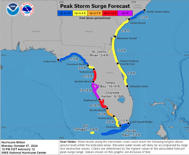
"A large area of destructive storm surge from #Milton will occur along parts of the west coast of Florida on Wednesday," the hurricane center warned. "This is an extremely life-threatening situation & residents should follow advice given by local officials & evacuate immediately if told to do so."
South Florida communities were already beginning to feel some of the storm's early impacts as Miami-Dade County and the Everglades reported flooding, said CBS News Miami meteorologist KC Sherman. Sherman told residents to expect a flood watch through Thursday.
"Milton is moving slowly but is expected to strengthen rapidly," the hurricane center said earlier Sunday. "There is increasing confidence that a powerful hurricane with life-threatening hazards will be affecting portions of the Florida west coast around the middle of this week."
Milton rapidly intensified over warm Gulf waters
Milton rapidly intensified as it moved over water with temperatures hovering around 85 degrees Fahrenheit, which Parkinson describes as like "premium octane fuel for any hurricane."
Exceptionally high sea surface temperatures have been made significantly more likely by human-caused climate change, according to analysis by Climate Central.
Parkinson had said Sunday that people in the potential path of the hurricane should prepare for the storm to be stronger than forecasts indicate.
"As always, this far out, people need to prepare for one category above, which means preparations should be for a Category 5 maximum, and a strong Category 4 landfall," Parkinson said.
Landfall location is key
Forecast models show Milton headed for Florida's west coast. The direction Milton approaches from is a large concern, Parkinson said. Instead of running parallel to the coast, Milton is coming in at a 90-degree angle.
"That means that storm surge will be piled into the coast," Parkinson said, comparing it to what happened in New Jersey during Hurricane Sandy.
The landfall location will be key, he explained.
"If landfall is south of a given location, storm surge will be minimal, rain will be heavy, and any of the worst wind will be confined to the first 25 miles from the eye," Parkinson said. "If landfall is north of a given location, they'll experience catastrophic and historic storm surge, relatively minimal rain, and wind confined to the first 25 miles from the eye. Storm surge will extend southward of the landfall point for the entire west coast."
Parkinson also explained that landfall to the north of Tampa Bay would be especially devastating for that metro area.
"At least half the model runs to give a St. Pete or north landfall. I cannot think of a worse case scenario than that for Tampa Bay," he said. "If that comes to fruition, it will be the worst natural disaster Tampa has ever seen. If, however, landfall occurs in Sarasota or south, Tampa will dodge the storm surge, but places like Fort Myers will bear the worst inundation."
Florida officials issue warnings
Gov. Ron DeSantis first issued emergency orders Saturday and then expanded the declaration Sunday to include 51 counties. He said Floridians should prepare for more power outages and disruptions, making sure they have a week's worth of food and water and were ready to hit the road.
"Evacuations are underway, and we have suspended tolls and opened roadway shoulders to make it easier for Floridians to get to safety," DeSantis said on social media Monday. "The State of Florida continues to fulfill requests from communities in the potential path of Hurricane Milton as we prepare for landfall. Hundreds of first responders will be embedded in potential impact sites along Florida's west coast to begin search and rescue operations as soon as the storm passes."
The St. Petersburg-Tampa Bay area was still cleaning up extensive damage from Helene and its powerful storm surge. Twelve people perished as Helene swamped the coast, with the worst damage in the state along the narrow, 20-mile string of barrier islands that stretch from St. Petersburg to Clearwater.
All classes and school activities in St. Petersburg's Pinellas County preemptively closed Monday through Wednesday as Milton approached, and Tampa opened city garages for free so people could park their cars safe from the next floodwaters.
The Pinellas County government also issued mandatory evacuation orders for long-term care facilities, assisted living facilities and hospitals in designated evacuation zones due to the threat posed by Hurricane Milton.
The National Hurricane Center warned of heavy rainfall of up to 15 inches in portions of the Florida Peninsula through Thursday, which could generate "considerable flash, urban and areal flooding, along with moderate to major river flooding."