Severe weather moves through Tri-State Area amid another heat wave. Maps show heat advisory, excessive heat warning.

NEW YORK -- Severe weather moved through parts of the Tri-State Area amid another heat wave Tuesday.
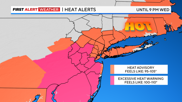
The First Alert Weather team has issued a Red Alert through Wednesday due to excessive heat and humidity, along with the continued risk of severe thunderstorms.
A heat advisory has been issued through 9 p.m. Wednesday for most of the area, and an excessive heat warning has also been issued through 8 p.m. Wednesday for central and southern New Jersey.
Severe thunderstorms cause damage across Tri-State Area
Torridly hot conditions defined Tuesday's weather, with soaring temperatures and even higher heat indices. That dangerous combination of high heat and humidity helped ignite another round of severe thunderstorms across the area Tuesday afternoon and evening, which has led to widespread damage, particularly in the Garden State.
Neighbors in Fords in Middlesex County said the storm was quick, and in a matter of minutes, it left downed power lines and trees scattered all over roadways and yards.
John Sheridan was working on his truck when the storm hit.
"It just started blowing harder and harder, so I stayed in the car. Branches, you know, debris started blowing past," he said.
In matter of minutes on Grissom Place, a tree came crashing down.
"The hood looks like it's crushed in, the mirror. Windshield smashed in," Sheridan said. "It's a little scary."
George McMahon's yard is full of downed trees.
"I heard cracking. I heard the trees cracking," he said.
The local fire department arrived on the scene and closed off the street to begin cleanup.
First Alert Weather maps
- Live Tri-State Area radar
- Live Long Island radar
- Live NYC northern suburbs radar
- Live Jersey Shore radar
- Tri-State temperatures
Tuesday night forecast
That severe threat will last through midnight, as quieter conditions move in during the overnight hours. Lows will be in the mid to upper 70s and it will feel quite sultry. It's very possible that the city won't drop below 80.
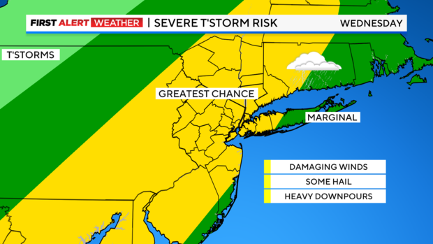
Soaring temperatures, thunderstorm chances return Wednesday
For Wednesday, just like on Tuesday, a mostly sunny start to the day will help temperatures soar into the low and mid 90s, while heat indices could reach as high as 110 in some areas.
A chance of thunderstorms returns for the afternoon and evening hours. It looks to be more even more widespread than Tuesday's storms. The storms will be capable of producing damaging winds, hail, and torrential downpours that can lead to flash flooding.
When will NYC's heat wave end?
Relief from the heat will come in the form of a cold front that will clear the region by Thursday afternoon. Behind that front lies a much more refreshing airmass.
Excessive heat explained
- What is a heat wave? Heat advisory?
- What to know about air quality in NYC
- Heat stroke symptoms in people and pets
- Find the best pools and beaches in NYC
- Summer heat safety guide
Stick with the First Alert Weather team for the latest forecast and weather alerts.