Thunderstorms move through Tri-State Area. NYC heat advisory extended for another day.
A skinny but tough line of storms passed through New York City around 6:30 p.m. Friday.
A Flood Advisory was issued but dropped. There was some localized flooding, but no major damage reports have surfaced just yet, except for reports of downed trees and wires in western Monmouth County.
Interactive Weather Radar
Right now, the line is significantly weaker. It will continue to move across Long Island, bringing gusty winds and quick downpours.
Behind the storms, much quieter conditions exist. It's very quiet right now in western New Jersey, and the models are not indicating another wave of storms.
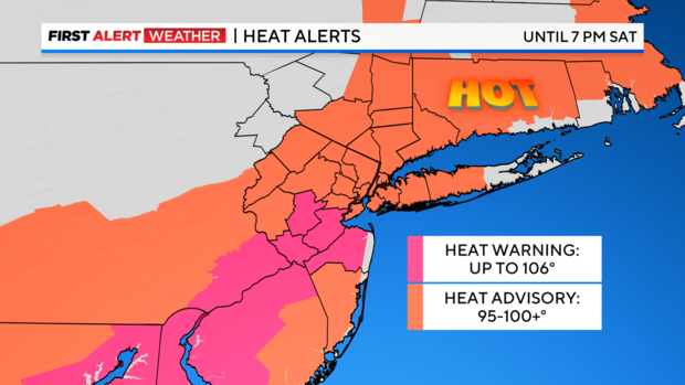
We hit 92 in New York City on Friday afternoon, and 95 in Newark, extending their heat wave to day number four. If we hit 90 in New York City on Saturday, we would have our fourth heat wave of the season. We will be very close.
There will be another Red Alert Saturday afternoon to encompass the extended Heat Advisory and the marginal risk for late day storms. We are anticipating a quiet morning, however.
First Alert Weather maps
- Live Tri-State Area radar
- Live Long Island radar
- Live NYC northern suburbs radar
- Live Jersey Shore radar
- Tri-State temperatures
Stick with the First Alert Weather team for the latest forecast and weather alerts.
