Francine makes landfall in Louisiana as Category 2 hurricane before weakening to tropical storm
Francine has weakened to a tropical storm. Get the latest coverage here.
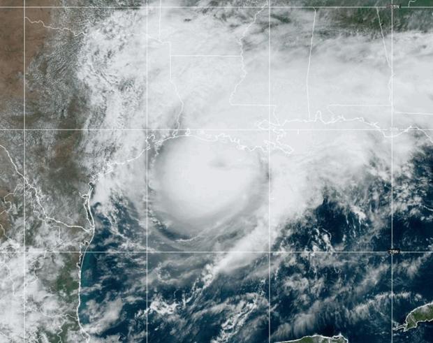
Francine made landfall early Wednesday evening in Louisiana at a Category 2 hurricane Wednesday afternoon before quickly weakening to a tropical storm.
Francine, which developed in the Gulf of Mexico on Monday, made landfall in southern Louisiana, the National Hurricane Center said with maximum sustained winds near 100 mph.
However, after making landfall, the storm quickly lost strength, weakening to tropical storm by late Wednesday night, when it registered maximum sustained winds of 70 mph.
Francine made landfall in Terrebonne Parish, about 30 miles south-southwest of Morgan City, the hurricane center said.
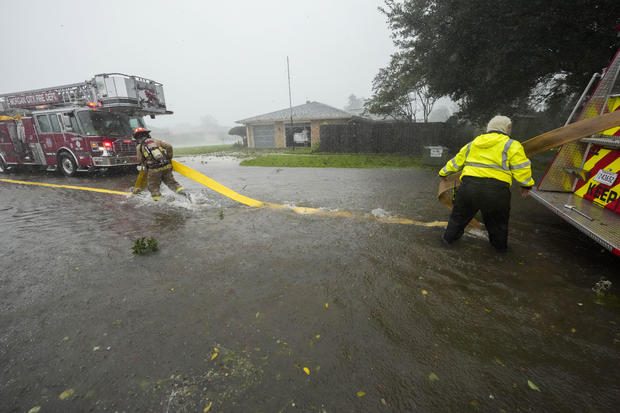
Despite weakening, it was still bringing powerful winds and heavy rains to Louisiana. The hurricane center warned southern Louisiana residents that "now is the time to stay inside and away from windows," and "have multiple ways to receive warnings and updates."
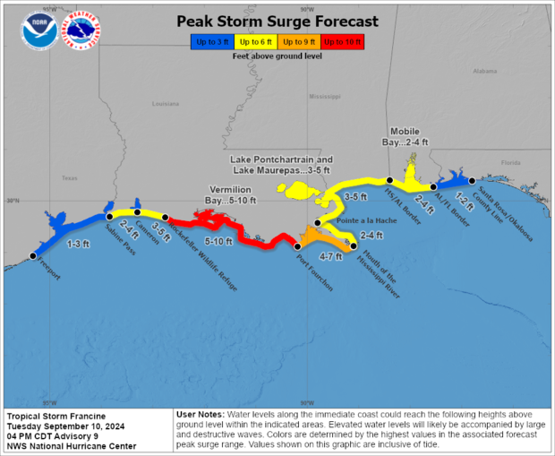
The hurricane center said that "life-threatening storm surge and hurricane conditions" were spreading onto the Louisiana coast Wednesday afternoon, with dangerous storm surge potentially hitting the Mississippi coastline as well.
Terrebonne Parish President Jason Bergeron told CBS News Wednesday that the levies were holding, but the water is rising.
"The ground is saturated with water, and as the levy system is closed that water has a harder time getting out, except for some areas that have some pumps," Bergeron said.
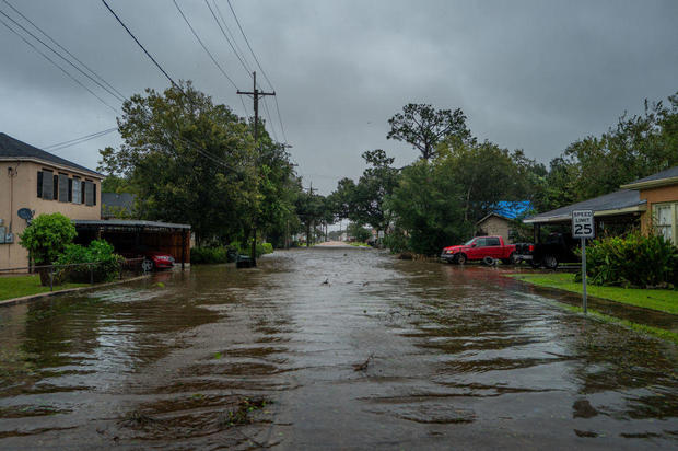
New Orleans could get up to 10 inches of rain, putting the city's water pump and drainage system to the test.
"Stay inside, hunker down," New Orleans Mayor LaToya Cantrell said. "Now is the time, between now as well as moving into midnight."
Prior to making landfall, Louisiana Gov. Jeff Landry, who earlier declared a state of emergency and requested disaster assistance from the U.S. government, cautioned residents against underestimating the hurricane based on its category.
"Just because it's a Category 1, or possibly Category 2, doesn't mean it's going to be a thunder bumper," Landry said at a news conference ahead of Francine's expected landfall Wednesday afternoon, where he urged people to stay indoors and follow any other instructions from local leadership, adding, "We have been through a lot here in Louisiana."
Francine was forecast to cross over southeastern Louisiana before moving northward over Mississippi Thursday.
The storm "is expected to bring storm total rainfall of 4 to 8 inches, with local amounts to 12 inches across much of Louisiana and Mississippi through Friday morning," the hurricane center said. There is potential for "considerable" flash and urban flooding. Southeastern Louisiana, including metropolitan New Orleans and Baton Rouge, are most vulnerable. So is southwestern Mississippi, including the entirety of its coastal region.
"The time to evacuate has now passed. It's time to go to ground and hunker down," Landry said a few hours before Francine's expected arrival. "We are no longer in the 'prepare for a hurricane.' We're in the 'respond to a hurricane.'"
Officials in Louisiana said four roadways were closed Wednesday afternoon in counties in the path of the hurricane, "due to rising water or closed floodgates."
Landry and other state officials have been coordinating with the Federal Emergency Management Agency for three days to develop their response, which includes at least 2,300 members of the Louisiana National Guard who had already been mobilized as the hurricane approached. There are also hundreds of boats, high-water vehicles and aircraft ready to assist with potential search and rescue operations as needed, officials said.
President Biden approved the emergency declaration for Louisiana that allows FEMA to coordinate disaster relief and supplement the state's response to the hurricane, the agency announced Wednesday.
Earlier, Louisiana Gov. Jeff Landry declared a state of emergency Monday evening, around the same time Mississippi Gov. Tate Reeves issued an emergency declaration for his state as well.
"This State of Emergency will allow parishes statewide to have the resources to help protect the life, safety, and welfare of the citizens of Louisiana," Landry said on social media. "Throughout this process, we will remain in constant contact with local officals and first responders and will assist them in every step of the way."
In Morgan City, many business owners and residents were boarding up and evacuating Tuesday, with lines at gas station getting longer throughout the day, and some even running out of fuel.
As an essential worker in a hospital maternity ward, Carole Duplantis of Houma, Louisiana, can't evacuate.
"We deliver babies even through the hurricanes," Duplantis said.
She told CBS News she was using sandbags to protect her home, which is still being renovated after it was damaged by Ida in 2021, which struck as a Category 4 hurricane.
"No, I am not recovered yet," Duplantis said of Ida.
Cars and trucks were lined up for blocks in downtown New Orleans Tuesday waiting to get sandbags from the parking lot of a local YMCA as people prepared to try to prevent flooding of their homes, The Associated Press reports.
Millions of people along the Gulf Coast were under hurricane warnings as the storm approached.
"We don't take this storm lightly because of the movement towards the East, which is closer to us," Randy Smith, sheriff of St. Tammany Parish north of New Orleans, said in a news conference Tuesday. "We're prepared for any emergencies that arise."
Storm surge warnings were in effect for areas from the Vermilion and Cameron Parish area in Louisiana to the Mississippi/Alabama Border, Vermilion Bay, Lake Maurepas and Lake Pontchartrain, and a coastal flood warning was in effect Wednesday for the length of the Alabama coast, including Mobile Bay.
A coastal flood warning means "moderate to major coastal flooding is occurring or imminent," the National Weather Service writes, noting that this degree of flooding "will cause serious risk to life and property."
"We all know that the current projected path of Francine looks like it's headed toward Louisiana," Texas Gov. Greg Abbott said in a news conference Tuesday afternoon in the southeastern Texas city of Beaumont, which is in a region that could be impacted by Francine. "We also know, however, that storms, even in the recent past, sometimes can deviate from what the prediction is. So for one, we're concerned about the possibility of the storm altering its course (and) moving more towards Texas, in which case the area that would be most likely challenged would be where we are right now, in Jefferson County, over in Orange County and surrounding areas."
He added that even if Francine stayed on its latest trajectory, Jefferson and Orange counties would still see "enormous challenges."
The Miami-based hurricane center explains that a hurricane warning means hurricane conditions are expected somewhere within the warning area, and it's typically issued hours before the earliest arrival of tropical-storm-force winds that would hinder weather preparations. A hurricane watch means hurricane conditions are possible within the watch area, and a storm surge warning means there's a danger of life-threatening inundation, from rising water moving inland from the coastline, during the next 36 hours in the indicated locations.
Francine's development followed an unusually calm August and early September in the Atlantic hurricane season. Francine is the Atlantic season's sixth named storm.
Experts had predicted one of the busiest Atlantic seasons ever and, The Associated Press notes, Colorado State University researchers said last week they still expect an above-normal season overall.