Hurricane Joaquin Intensifies; Parts Of Tri-State Area In Possible Path
NEW YORK (CBSNewYork/AP) -- The Tri-State is keeping a close eye on Hurricane Joaquin as it strengthens.
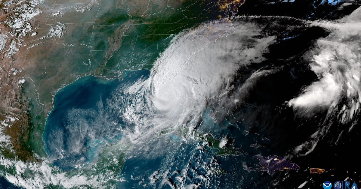
As CBS2's Lonnie Quinn reported, Joaquin was upgraded from a Category 1 hurricane to a Category 2, and finally to a Category 3 over the course of the afternoon and evening hours. Winds were up to 115 mph as of 11 p.m.
The storm is expected to bump up to Category 4 with wind speeds of at least 130 mph. The storm will likely weaken to a Category 2 hurricane as it moves north over relatively cooler water.
Nearly all models now suggest Joaquin will make landfall on Sunday, likely somewhere between the Chesapeake Bay and North Carolina. But those models still puts New York City and the rest of the Tri-State Area in a cone in which they will be affected.
Meanwhile, a coastal flood advisory is in effect for Thursday and Friday – completely independently of Joaquin. The advisory covers northern New Jersey, southeastern New York and southern Connecticut from Thursday through Tuesday.
If Joaquin makes landfall around the Outer Banks of North Carolina, a counterclockwise spin will push moisture up into the Tri-State Area. With so much rain already expected before the storm, coastal and even inland flooding are a threat, Quinn reported.
http://www.nhc.noaa.gov/storm_graphics/AT11/refresh/AL1115W5_NL+gif/114425W5_NL_sm.gif
Preparations were under way from the city to the Jersey Shore late Wednesday. In Hoboken, "no parking" signs were posted on flood-prone streets, and storm drains had been cleared of debris, CBS2's Tony Aiello reported.
Police barricades were also in place.
And farther south, as CBS2's Steve Langford reported, Belmar is a town that does not believe in taking any chances should a storm named Joaquin come crashing in.
"We know it's coming," Belmar Mayor Matt Doherty told WCBS 880's Marla Diamond. "So it's our obligation as a town to prepare for it, and then that's what we're doing far in advance, and we're going to be very aggressive about it."
Bulldozers have been set up to create sand berms on the beach, and Lake Como was being pumped Wednesday afternoon.
"By lowering this lake, we help mitigate against flooding into all the homes that surround it, so we have hundreds of families that are right now scared," Doherty told CBS2's Langford.
Doherty knows the people of his town remain in many respects haunted by the ghosts of Sandy.
"We've learned a lot of lessons from Sandy, and we have a lot of resources now we never had before," Doherty said.
Up the shore in Asbury Park, a preventive ditch was being dug on the beach, while in Long Branch, a lone bulldozer operator toils against the possibility of a destructive storm. Trash cans were being removed from the beach in Harvey Cedars.
And in Sea Bright, New Jersey, tiny Center Street will be hit especially hard. Resident Jake Higgins knows what he could be in for.
"I just bought the house," Higgins said. "Me and my brother bought it a year ago from an owner who got hit by Sandy."
Higgins knows what he's in for, and is glued these days to the weather forecast.
"Definitely listening to it every minute of the day," he said.
But just down the street, there was a certain calm before the storm.
"You know, there's not much you can do," said Asheley Krakowski of Sea Bright. "We just moved, whatever, out of the way."
In Harvey Cedars, objects that can float away or fly off in high winds were being removed from beaches, while in Atlantic City, rescue vehicles and boats were made ready.
In Neptune City, a storm Prepare-a-Thom had been planned for Wednesday night, but it was canceled due to more immediate weather concerns.
But back in New York City, an emergency preparation training session was held on the Upper East Side, where memories of flooding from Sandy remained vivid.
"I have backpacks ready, too, already," said Aubrey Mason of the Upper East Side. "Disaster can happen anytime."
City officials were preparing for the possible effects late Wednesday.
"We're actively watching it on an hourly basis," said New York City Emergency Management Commissioner Joe Esposito. "We think we have a big potential for this hurricane to have an effect on New York."
Upper East Side residents went home with emergency go bags to help them equip for whatever the next few days bring.
Meanwhile to the east, PSEG Long Island said it is performing system checks on critical equipment, making sure it is stocked up on essential inventory such as fuel, and will have personnel on hand to deal with any weather-related outages.
"We have activated our storm preparedness plans so we can respond quickly to the approaching weather," said John O'Connell, vice president of Transmission & Distribution at PSEG Long Island.
The utility will call in additional contractors and tree trim crews if necessary, spokesperson Elizabeth Flagler told 1010 WINS.
The area had already gotten a taste of things to come as heavy rain hit parts of the Tri-State area Tuesday night and Wednesday morning.
The overnight storms downed trees and caused ponding on some roads, slowing traffic during the morning commute.
LINKS: Traffic & Transit | Forecast | Track The Rain
In Alpine, New Jersey, a tree came down onto the Palisades Parkway near Exit 4, blocking a part of the southbound lanes during the morning commute.
Crews in Passaic also had to work to right a pole with live wires that was pitched precariously on Totowa Road.
Storms Leave Thousands Of Customers Without Power On Long Island
In New Hyde Park, Long Island, the combination of rain and wind took down a massive tree, sending a tangle of branches and electrical wires onto a parked car, CBS2's Elise Finch reported.
In total, fallen power lines put approximately 9,000 PSEG Long Island customers in the dark, WCBS 880 Long Island Bureau Chief Mike Xirinachs reported. Most of the outages were reported on the North Shore.
A high rip current risk remains in effect through Wednesday night along the entire New Jersey coast. Forecasters said southerly winds combined with swells of 5 to 7 feet are creating rough seas. Widespread minor tidal flooding is expected during high tide beginning Thursday and possibly lasting into the weekend.
There is some good news: The wet weather helped put a bit of a dent in the region's rainfall deficit.
Since Jan. 1, the area had just over 30 inches of rain and, including Wednesday morning's rainfall, the region still has a 7-inch deficit, Finch reported.
(TM and © Copyright 2015 CBS Radio Inc. and its relevant subsidiaries. CBS RADIO and EYE Logo TM and Copyright 2015 CBS Broadcasting Inc. Used under license. All Rights Reserved. This material may not be published, broadcast, rewritten, or redistributed. The Associated Press contributed to this report.)


