Heat wave brings another dangerously hot stretch to Tri-State Area. Here's how high temps could soar.
NEW YORK -- Extreme heat returned Sunday and it's going to get hotter over the next few days.
Alerts/Advisories
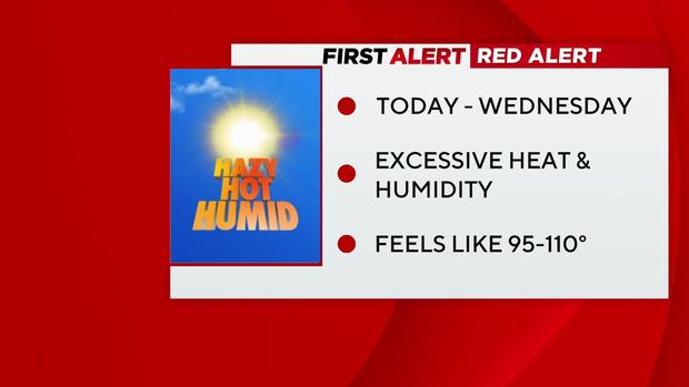
A Red Alert is in place from Monday through Wednesday due to excessive levels of heat and humidity, which may make it feel like 95-110 degrees.
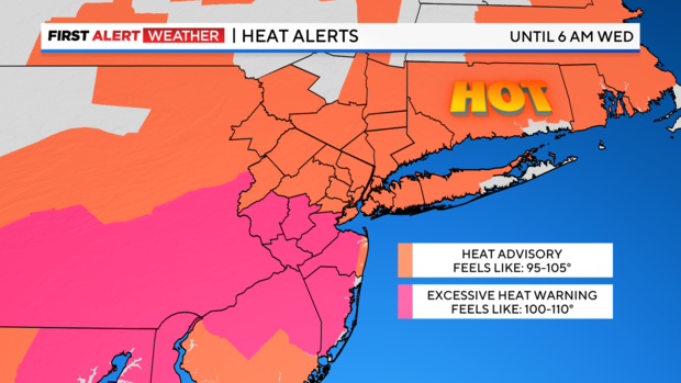
A Heat Advisory is in place for most of the area through Tuesday evening.
An Excessive Heat Warning in place for central and southern New Jersey through Wednesday morning.
An Air Quality Alert is in place through from 11 a.m. to 11 p.m. Monday for New York City, Long Island, the lower Hudson Valley, the Jersey Shore and southern Connecticut.
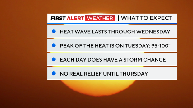
What to expect
The third heat wave of 2024 is now in full swing and will last through Wednesday. Lows Sunday night will won't be so low, mainly dropping into the mid and upper 70s. Patchy fog is possible once again, especially for areas that saw rain on Sunday, and along the coast.
For Monday, temperatures will rise even further, topping out in the mid to upper 90s, while heat indices may exceed 100 in many areas. A chance of thunderstorms will return for the afternoon and evening hours, with our northwestern suburbs seeing the greatest chance. While the severe threat is minimal, an isolated severe storm is possible.
This current heat wave is likely to be our most intense one yet this year. Peak heating is expected on Tuesday, when many locations in New Jersey may reach the century mark. With high humidity in place, heat indices will be through the roof, reaching as high as 110. The forecasted high of 97 in Central Park would be the highest temp since 2021. It is also likely that our average number of 90-degree days per year will be reached once the heat wave ends. The average is 15 and we are already at 12 in mid-July.
Relief from the heat will come in the form of a cold front that will arrive later on Wednesday. The front may spark some strong to severe thunderstorms, but then behind it, a much more refreshing airmass moves in.
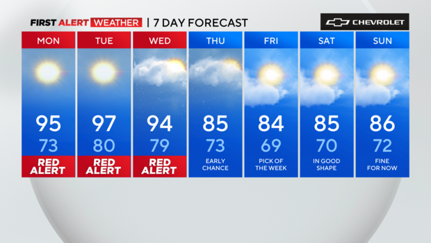
The week ahead
Monday: Warm and muggy in the morning morning with a shower chance to the east. Afternoon is hazy, hot and humid with a chance of thunderstorms, especially north and west of New York City. Highs temps will be in the mid 90s, but it will feel like 100-105.
Tonight, a shower or storm is possible, mainly north and west of the city. It will be warm with lows near 80, with 70s and 60s more likely across the suburbs.
Tuesday: Stifling heat and humidity with isolated thunderstorms in the afternoon. Near-record highs in the upper 90s, but feeling more like 100-105.
Wednesday: Scattered thunderstorms in the afternoon and evening. Some storms may be severe. Oppressive levels of humidity. Highs in the low to mid 90s, but feeling like 100-105.
Thursday: Showers and thunderstorms in the morning. Highs in the low to mid 80s.
Friday: Mostly sunny with less humid. Highs in the 80s.